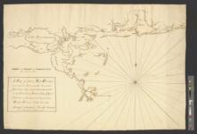
A map of part of West Florida done under the direction of the honourable John Stuart esqr: & by him humbly inscribed to his excellency Thomas Gage esquire general and commander in chief of all his majesty's forces in North-America / survey'd & drawn by Bernard Romans beteen the month of June 1772 & January 1773.
About this Item
Record Details
- Title
- A map of part of West Florida done under the direction of the honourable John Stuart esqr: & by him humbly inscribed to his excellency Thomas Gage esquire general and commander in chief of all his majesty's forces in North-America / survey'd & drawn by Bernard Romans beteen the month of June 1772 & January 1773.
- Date
- [1773]
- Notes
- Finished, pen and ink chart showing in detail the coastline from the Mississippi Delta to Pensacola.
- This map and the large map of West Florida (Brun 663) were taken to General Gage by Romans, and both were prepared under the supervision of John Stuart.
- Stuart mentions this particular map in his letter to Gage from Charleston of April 22, 1773, Gage Papers.
- Photostat copy of manuscript letter of explanation filed with map.
- Names and Subjects
- Gage, Thomas,--1721-1787.
- Manuscript maps.
- Maps shelf.
- Thomas Gage Papers.
- Brun Guide.
- Gulf States--Manuscript maps.
- West Florida--Manuscript maps.
- Louisiana--Manuscript maps.
- Mississippi--Manuscript maps.
- Alabama--Manuscript maps.
- Florida--Manuscript maps.
- Stuart, John,--1718-1779.
- Collection Title
- Thomas Gage papers
- Collection Creator
- Gage, Thomas, 1721-1787
- ID
- 883
- Barcode
- B2500733
- Physical Description
- 1 ms. map ; 54.5 x 76.1 cm.
- Map Scale
- Scale 1:300,000.
- Sponsor
- Digitized through a gift from Barry Lawrence Ruderman Antique Maps
- Repository
- William L. Clements Library
- Date Added/Updated
- 2019-07-18 19:49:54
Technical Details
- Collection
- William L. Clements Library Image Bank
- Image Size
- 13384 x 9080
- File Size
- 5 MB
- Record
- 883
- Link to this Item
-
https://quod.lib.umich.edu/w/wcl1ic/x-883/wcl000977
Rights and Permissions
The University of Michigan Library provides access to these materials for educational and research purposes. These materials may be under copyright. If you decide to use any of these materials, you are responsible for making your own legal assessment and securing any necessary permission.
Related Links
- More Item Details
- Catalog Record
IIIF
- Manifest
-
https://quod.lib.umich.edu/cgi/i/image/api/manifest/wcl1ic:883
Cite this Item
View the Help Guide for more information.
- Full citation
-
"A map of part of West Florida done under the direction of the honourable John Stuart esqr: & by him humbly inscribed to his excellency Thomas Gage esquire general and commander in chief of all his majesty's forces in North-America / survey'd & drawn by Bernard Romans beteen the month of June 1772 & January 1773.". https://quod.lib.umich.edu/w/wcl1ic/x-883/wcl000977. In the digital collection William L. Clements Library Image Bank. William L. Clements Library, University of Michigan Library Digital Collections. June 20, 2025.