Select all items
add
Add items to portfolio
ID
6414
Title
[Survey for a proposed canal from Westminster to near Marlborough].
Date Added/Updated
2018-11-06 12:50:22
Add item to portfolio
ID
6460
Title
A plot of nine towns of Jackson County and three of Calhoun with some of the leading roads : Roads marked by too lines and dotted.
Date Added/Updated
2018-11-06 12:49:36
Add item to portfolio
ID
6320
Title
[Plan of properties on Spring Garden Street, Philadelphia].
Date Added/Updated
2018-11-06 12:49:11
Add item to portfolio
ID
6374
Title
[Topographic map exercise] / Auguste Blondeau, 1810, fait à l'Ecole militaire de St. Cyr.
Date Added/Updated
2018-11-06 12:48:44
Add item to portfolio
ID
6524
Title
[Albert Island, Ontario].
Date Added/Updated
2018-11-06 12:47:59
Add item to portfolio
ID
6536
Title
Cartes pour servir a l'histoire de la Nouvelle-France jusqu'en 1763 : Dressées principalement d'après des materieux inédits conserves dans les archives du ministère de la marine / par L. Dussieux, 1851.
Date Added/Updated
2018-11-06 12:47:20
Add item to portfolio
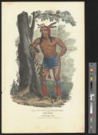
ID
6834
Title
Waa-Bin-De-Ba or the White Headed Eagle : A Chippeway Chief / Painted by J.O. Lewis.
Date Added/Updated
2018-11-06 12:46:41
Add item to portfolio
ID
6452
Title
[Part of modern Westmoreland County].
Date Added/Updated
2018-11-06 12:45:59
Add item to portfolio
ID
6483
Title
[Alabama, 1839].
Date Added/Updated
2018-11-06 12:45:23
Add item to portfolio
ID
6459
Title
Plan of Detroit by John Mullett : Engraved & published by J.O. Lewis, 1830.
Date Added/Updated
2018-11-06 12:44:55
Add item to portfolio
ID
6587
Title
Map of that portion of the battle-field of Chickamauga where Genl Thomas opened the battle Sept. 19th 1863 : Also map of country from Mission Mills to Alexander's Bridge / by D. McCook.
Date Added/Updated
2018-11-06 12:44:31
Add item to portfolio
ID
6471
Title
Whitehaven Harbour, 1836.
Date Added/Updated
2018-11-06 12:43:57
Add item to portfolio
ID
6830
Title
At-Te-Conse or the Young Rein Deer : A Chippeway Chief / Painted by J.O. Lewis.
Date Added/Updated
2018-11-06 12:43:13
Add item to portfolio
ID
6788
Title
Caa-Taa-Ke Mung-Ga or the Speckle'd Loon : A Miami Chief / Painted at the treaty of Prarie du Chien 1825 by J.O. Lewis.
Date Added/Updated
2018-11-06 12:42:31
Add item to portfolio
ID
6687
Title
San Francisco. 1856.
Date Added/Updated
2018-11-06 12:41:53
Add item to portfolio
ID
6679
Title
Westinghouse Companies' map of St. Louis and the 1904 World's Fair Grounds.
Date Added/Updated
2018-11-06 12:41:20
Add item to portfolio
ID
6597
Title
[Kauai].
Date Added/Updated
2018-11-06 12:41:00
Add item to portfolio
ID
6806
Title
Chat-O-Nis-See : Pottowattomie Chief / Painted at the treaty of Fort Wayne by J.O. Lewis 1827.
Date Added/Updated
2018-11-06 12:40:18
Add item to portfolio
ID
6305
Title
Nehemiah Ramsdell Groton.
Date Added/Updated
2018-11-06 12:39:52
Add item to portfolio
ID
6505
Title
Map of the eastern portion of Pennsylvania exhibiting the superior advantages of Columbia as a site for the national foundry.
Date Added/Updated
2018-11-06 12:39:26
Add item to portfolio
ID
6732
Title
A View of the Great Cohoes Falls on the Mohawk River : The Fall about Seventy feet the River near a Quarter of a Mile.
Date Added/Updated
2018-11-06 12:39:10
Add item to portfolio
ID
6449
Title
[Isaac Sebring's map includes part of Spruce, Fox, Eagle, and Columbia streets in the city of Albany].
Date Added/Updated
2018-11-06 12:38:25
Add item to portfolio
ID
6647
Title
[Sketches, maps, and notes of the area of the Spanish River and Vermillion River, Sudbury District, Ontario, on the north shore of Lake Huron opposite Great Manitoulin Island, 1889-1890].
Date Added/Updated
2018-11-06 12:37:57
Add item to portfolio
ID
6297
Title
[A plot of Wm Young's land including Delaware paper mill].
Date Added/Updated
2018-11-06 12:37:31
Add item to portfolio
ID
6483
Title
[Alabama, 1839].
Date Added/Updated
2018-11-06 12:36:55
Add item to portfolio
ID
6787
Title
Kaa-Nun-Der-Waaguinse-Zoo or the Berry Picker : A famous Chippewa Chief / Painted at the Treaty of Praria du Chien 1825 by J.O. Lewis.
Date Added/Updated
2018-11-06 12:36:18
Add item to portfolio
ID
6470
Title
[Sketch of compass traverse in Boston Harbor].
Date Added/Updated
2018-11-06 12:35:33
Add item to portfolio
ID
6324
Title
Map of Watsons farm at Bushington Bucks County Pa.
Date Added/Updated
2018-11-06 12:34:57
Add item to portfolio
ID
6624
Title
North and South longitudinal Section of Gravel banks.
Date Added/Updated
2018-11-06 12:34:23
Add item to portfolio
ID
6414
Title
[Survey for a proposed canal from Westminster to near Marlborough].
Date Added/Updated
2018-11-06 12:33:52
Add item to portfolio
ID
6577
Title
Map of the country occcupied by the Federal and Confederate armies on the 18th & 31st July 1861 / by Warder & Catlett, surveyors & publishers.
Date Added/Updated
2018-11-06 12:33:07
Add item to portfolio
ID
6398
Title
Rough chart of the Sault St. Mary, N. lat. 46⁰ 39'.
Date Added/Updated
2018-11-06 12:32:20
Add item to portfolio
ID
6766
Title
Cha-Co-To : A Pottawatomie Chief / Taken at the Treaty of Massinnewa, Indiana by J.O. Lewis 1827.
Date Added/Updated
2018-11-06 12:31:28
Add item to portfolio
ID
6601
Title
Survey of the President, Porcupine, and Redfield Petroleum Co.'s lands, containing in all 8,400 acres, situate in President and Pinegrove townships, Venango County, Pennsylvania / T & J Slator, city surveyors, 39 Nassau St N.Y.
Date Added/Updated
2018-11-06 12:30:53
Add item to portfolio
ID
6520
Title
[Middle East] / A. King.
Date Added/Updated
2018-11-06 12:29:21
Add item to portfolio
ID
6801
Title
Me-No-Quet : A distinguish'd Pottowattomie Chief / Painted at the treaty of Fort Wayne 1827 by J.O. Lewis.
Date Added/Updated
2018-11-06 12:28:35
Add item to portfolio
ID
6713
Title
Lakewood, Lake Chautauqua : On Line of the Atlantic and Great Western Railroad. / Painted by T. C. Lindsay ; Engraved by W. Wellstood.
Date Added/Updated
2018-11-06 12:27:27
Add item to portfolio
ID
6531
Title
Map of the city of Buffalo.
Date Added/Updated
2018-11-06 12:26:58
Add item to portfolio
ID
6829
Title
O-Wan-Ich-Koh or the Little Elk : A Winnebago Chief / Painted at the treaty of Prarie du Chien by J.O. Lewis.
Date Added/Updated
2018-11-06 12:26:17
Add item to portfolio
ID
6763
Title
Waa-Na-Taa or the Foremost in Battle : Chief of the Sioux Tribe / Painted by J.O. Lewis at the Treaty of Prarie du chien 1825.
Date Added/Updated
2018-11-06 12:25:39
Add item to portfolio
ID
6446
Title
Boston and Albany Rail Road : Profile from Grouts Summit in Spencer to Connecticut River, December 1828 / Jas. F. Baldwin, engr.
Date Added/Updated
2018-11-06 12:24:59
Add item to portfolio
ID
6559
Title
Apostle Islands and harbor of Bayfield and its surroundings.
Date Added/Updated
2018-11-06 12:24:15
Add item to portfolio
ID
6822
Title
O-Hya-Wa-Nim-Ce-Kee or the Yellow Thunder : A Chippeway Chief / Painted by J.O. Lewis at the treaty of Fond du Lac 1826.
Date Added/Updated
2018-11-06 12:23:33
Add item to portfolio
ID
6466
Title
The British islands in the West Indies.
Date Added/Updated
2018-11-06 12:22:30
Add item to portfolio
ID
6722
Title
View of the Farm where the Murder of the Deering Family was Committed by the fiend Antoine Probst on April 7th 1866.
Date Added/Updated
2018-11-06 12:22:00
Add item to portfolio
ID
6435
Title
Ohio.
Date Added/Updated
2018-11-06 12:21:35
Add item to portfolio
ID
6575
Title
Sketch of the seat of war in Alexandria & Fairfax Cos. / by V.P. Corbett, Washington City, May 31st 1861.
Date Added/Updated
2018-11-06 12:20:40
Add item to portfolio
ID
6323
Title
[Part of modern Burlington County].
Date Added/Updated
2018-11-06 12:20:12
Add item to portfolio
ID
6288
Title
North America with the West India islands.
Date Added/Updated
2018-11-06 12:19:57
Add item to portfolio
ID
6833
Title
Wa-Em-Boesh-Kaa : A Chippeway Chief / Painted at the treaty of Fond du Lac by J.O. Lewis 1826.
Date Added/Updated
2018-11-06 12:19:21
Add item to portfolio