Search Results

Options

Filters

601 to 650 of 9189 results

sort Sort by Date Added/Updated None Relevance Title Creator Date ID Date Added/Updated
ID
561
Title
A map of the sea coast of Georgia & the inland parts thereof extending to the westward of that part of Savannah called Broad River including the several inlets, rivers, islands, sounds, creeks, rivulets, towns, roads, forts & most remarcable places therein : Performed at the request of his exclly. James Wright esqr. captn. genl. & governor in chief of the said province the 20th day of August 1763 & in the third year of the reign of his majesty King George III / by Henry Yonge, JGW De Brahm surs. genl.
Date Added/Updated
2019-07-18 19:18:03
ID
8594
Title
[A floor plan showing the locations of officers' quarters after a move]
Date Added/Updated
2019-07-18 19:17:39
ID
8402
Title
Plan of Fort Fanning, for 10 guns, and 300 men / Am: D'Aubant, c. engr., March 1st, 1779.
Date Added/Updated
2019-07-18 19:17:10
ID
8515
Title
[A small map of the Pacific Northwest, highlighting the locations of Vancouver Island, Victoria, Port Angeles, Seattle, the Puget Sound, and the Pacific Ocean]
Date Added/Updated
2019-07-18 19:16:45
ID
8205
Title
[Island of Dominica].
Date Added/Updated
2019-07-18 19:16:32
ID
8363
Title
A chart of Tibee Inlet in Georgia / A: B: July 30th 1776.
Date Added/Updated
2019-07-18 19:16:15
ID
8603
Title
[Edward Van Winkle's horse, Prince, standing at the bottom of a cut before attempting to run up the side]
Date Added/Updated
2019-07-18 19:15:45
ID
8317
Title
[Part of the modern counties of Oconee, Pickens, Anderson, and Greenville].
Date Added/Updated
2019-07-18 19:15:23
ID
8223
Title
Plan of a fort designed to be erected upon the harbour of St. Iohn's in Newfoundland mounting 112 cannon, and containing barracks, casemates, and store houses for 1000 men and their provisions of all spiecies [sic] for twelve months : Projected according to the orders of the Honble. Board of His Majesty's Ordnance dated the 3rd April 1765 / by Capt. Hugh Debbieg chief engineer of Newfoundland.
Date Added/Updated
2019-07-18 19:14:40
ID
8611
Title
[Three capital letter 'F's in a circle]
Date Added/Updated
2019-07-18 19:14:01
ID
8384
Title
Sketch of part of the road from Freehold to Midde Town shewing the skirmish between the rear of the British army under the command of his excellency Genl. Sir Henry Clinton and the advanced corps of the rebel army June 28th 1778.
Date Added/Updated
2019-07-18 19:13:28
ID
8562
Title
[A diagram showing how a fleet of 18 ships, each with 8 guns, would match up against a fleet of 12 ships, each with 12 guns]
Date Added/Updated
2019-07-18 19:13:00
ID
8543
Title
[A coat of arms featuring a banner with the Latin phrase 'Corona Mea Christus' below the head of a horse and a shield with a cross and three cirlces within three diamonds]
Date Added/Updated
2019-07-18 19:12:43
ID
8347
Title
A map of the environs of Boston.
Date Added/Updated
2019-07-18 19:12:23
ID
8509
Title
[Riffles with leveled cleats catching falling gold]
Date Added/Updated
2019-07-18 19:12:04
ID
8646
Title
[A diagram illustrating how Edward Van Winkle transformed a German shell into a picture frame for his desk]
Date Added/Updated
2019-07-18 19:11:41
ID
8251
Title
City of St. Augustine and environs.
Date Added/Updated
2019-07-18 19:11:00
ID
8212
Title
Plan no. 6 shewing the profils cut thro' the different works by the yellow lines seen on plan no. 3.
Date Added/Updated
2019-07-18 19:10:31
ID
8645
Title
[A diagram illustrating the inside of a gun shell]
Date Added/Updated
2019-07-18 19:10:05
ID
8521
Title
[Scribbles on the side of a letter, possibly a failed attempt at drawing a Vienna coffee pot with a glass lid]
Date Added/Updated
2019-07-18 19:09:48
ID
8550
Title
[Rover, a carrack ship, sailing in choppy waters]
Date Added/Updated
2019-07-18 19:09:22
ID
8415
Title
A sketch of part of the island of Ste Lucie.
Date Added/Updated
2019-07-18 19:08:48
ID
8304
Title
[Map of East Florida from St. Augustine to Tampa Bay].
Date Added/Updated
2019-07-18 19:08:03
ID
8458
Title
[Three enormous mountains towering over three palm trees and a thatched hut on a sandy beach on the coast of Soufrière]
Date Added/Updated
2019-07-18 19:07:39
ID
8329
Title
[A plan of the entervale [sic] and hundred acre lotts in the township of Piermont].
Date Added/Updated
2019-07-18 19:07:16
ID
8225
Title
Plan of the roads between Boston and Albany : Survey'd by order of the governor in pursuance of a resolution of the General Court of the Massachusetts Bay / by Frans. Miller. A copy by W. Brasier.
Date Added/Updated
2019-07-18 19:06:16
ID
8372
Title
[Philadelphia].
Date Added/Updated
2019-07-18 19:05:16
ID
8585
Title
[A welcome sign to an Indian village]
Date Added/Updated
2019-07-18 19:04:47
ID
8549
Title
[A small ship with two masts sailing in the water]
Date Added/Updated
2019-07-18 19:04:32
ID
8211
Title
Plan (no. 5) shewing the half bastion C with its foundations and the rampart towards the river side, as far as the loop-hole wall beginning at E in plan (no. 3) with it's casemates and profils cut by the yellow lines thro' the work.
Date Added/Updated
2019-07-18 19:04:16
ID
8500
Title
[A trench reaching three feet below the Goodrich's cellar; and a drain pipe in a trench, sitting below layers of stone, burlap, hay, and soil]
Date Added/Updated
2019-07-18 19:03:57
ID
8471
Title
[A plumbing diagram illustrating the desired system of piping for the Goodrich home]
Date Added/Updated
2019-07-18 19:03:27
ID
8619
Title
[A machine gun, fired by a German spy impersonating an American captain, with a range of fire dangerously close to a group of American soldiers]
Date Added/Updated
2019-07-18 19:02:58
ID
8216
Title
Chart of the Straits of Magellan.
Date Added/Updated
2019-07-18 19:02:28
ID
8376
Title
Part of the city of New York, 27th Augt: 1778 [and] part of Long Island.
Date Added/Updated
2019-07-18 19:01:53
ID
8412
Title
[A sketch of the disposition of the force at New York for the defence of the port].
Date Added/Updated
2019-07-18 19:01:09
ID
8397
Title
Plan of the fort of Annapolis Nova Scotia in its present state 1779.
Date Added/Updated
2019-07-18 18:59:57
ID
8311
Title
Plan of Niagara.
Date Added/Updated
2019-07-18 18:59:26
ID
8496
Title
[A large copper canister from the Maria Theresa, to be used as an umbrella stand once polished]
Date Added/Updated
2019-07-18 18:59:03
ID
8464
Title
[The USS Constellation's reaction to a monstrous wave, shown in three steps: (1) the ship rolling towards the wave, (2) the ship being thrown over the wave, and (3) the ship lurching towards the wind]
Date Added/Updated
2019-07-18 18:58:47
ID
8531
Title
[Printed stationery for the Office of the Postmaster General, featuring the seal of the former United States Post Office Department: a postal carrier riding on horseback, the horse galloping above a patch of grass]
Date Added/Updated
2019-07-18 18:58:22
ID
8292
Title
[Part of modern Westchester County].
Date Added/Updated
2019-07-18 18:58:07
ID
8548
Title
[A coat of arms eagle with a star on its chest, opening its wings, standing on a striped bar above both a shield with two birds, and a banner reading 'Ad Diem Tendo']
Date Added/Updated
2019-07-18 18:57:50
ID
8260
Title
The harbour of Halifax.
Date Added/Updated
2019-07-18 18:57:11
ID
8465
Title
[The top half of an evening dress purchased in Paris, featuring a wide lapel and puffy sleeves extending to one's elbow; a close up view of the puffy sleeve on a dress; and the ruching trim at the bottom of a dress]
Date Added/Updated
2019-07-18 18:56:41
ID
8385
Title
[Part of modern Monmouth County, 1778].
Date Added/Updated
2019-07-18 18:56:22
ID
8237
Title
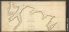
A plan of the sea coast from Gage Point to Cumberland Cape including Dartmouth and Granby Bays with the coal mines in that extent taken from the large survey of the island of Cape Britain survey'd agreable to the orders and instructions of the right honble. the Lords Commissioners of Trade and Plantations / by Samuel Holland esqr surveyor general for the northern district of North America &c.
Date Added/Updated
2019-07-18 18:55:38
ID
8633
Title
[A diagram illustrating the gifts Edward Van Winkle received for St. Nicholas Eve]
Date Added/Updated
2019-07-18 18:54:59
ID
8233
Title
A plan of New Orleans / drawn by Ph: Pittman lieut. 15th Regt. engineer at Mobile.
Date Added/Updated
2019-07-18 18:54:35
ID
8226
Title
A plan of the Magdelain, Brion, Bird and Entry islands reduced from the large survey made agreable to the orders and instructions of the right honourable, the Lords Commissioners for Trade and Plantations / by Samuel Holland esqr. surveyor general of the northern district of America.
Date Added/Updated
2019-07-18 18:54:01
Do you have questions about this content? Need to report a problem? Please contact us.