Plane trigonometry with practical applications, by Leonard E. Dickson.
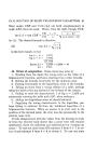
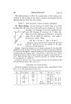
Ch. VI] NAVIGATION: DEAD RECKONING 71 50. The Mercator chart. A clear understanding of the leading method of making a map of the earth's surface is of great importance not only in navigation but also in geography and other earth sciences. The student will not fail to appreciate the practical nature of this topic. The earth's surface is mapped on the interior of a rectangle in such a way that the meridians are represented by parallel straight lines perpendicular to the straight line representing the equator, while the parallels of latitude are represented by straight lines parallel to the line representing the equator. Since the earth's meridians converge at the poles and yet have been plotted as parallel lines, there has been an opening out of these meridians, i.e., a stretching of east and west lengths. But we desire that any small figure on the map shall be of the same shape as the corresponding figure on the earth. Hence there must be simultaneously a stretching of north and south lengths. For a very short such vertical length in latitude L, the stretching factor is sec L, when the earth is regarded as a sphere. For, by Art. 48, diff. long. = dep. X see L. On a Mercator chart we agreed that the east and west length called departure should be stretched until it becomes equal to the corresponding diff. long. mapped unstretched on the line representing the equator. Hence dep. has been stretched in the ratio sec L, and we agreed to use the same stretching factor for small vertical lines. This argument is valid only for a very short arc, say one minute of arc. Given a longer arc extending from the equator vertically to lat. 5~ N, we divide it into 300 arcs each equal to a minute and hence obtain the stretched arc containing sec 1' + sec 2' +... + sec 300' minutes. It is too laborious to compute such sums without the aid of integral calculus, which leads to a formula convenient for computation.1 1 For latitude L the number of nautical miles in the stretched latitude is log tan (45~+ 'L) - r(e2 sin L+ Ie4 sin' L +...).4343 where r is the equatorial radius and e is the eccentricity of the ellipse whose rotation produces the earth's surface.
-
Scan 1

Page #1
-
Scan 2

Page #2 - Title Page
-
Scan 3

Page #3
-
Scan 4

Page III
-
Scan 5
Page IV
-
Scan 6

Page V
-
Scan 7

Page VI
-
Scan 8

Page VII - Table of Contents
-
Scan 9

Page VIII - Table of Contents
-
Scan 10

Page IX - Table of Contents
-
Scan 11

Page X - Table of Contents
-
Scan 12

Page XI - Table of Contents
-
Scan 13

Page #13
-
Scan 14

Page 1
-
Scan 15

Page 2
-
Scan 16

Page 3
-
Scan 17

Page 4
-
Scan 18

Page 5
-
Scan 19

Page 6
-
Scan 20

Page 7
-
Scan 21

Page 8
-
Scan 22

Page 9
-
Scan 23

Page 10
-
Scan 24

Page 11
-
Scan 25

Page 12
-
Scan 26

Page 13
-
Scan 27

Page 14
-
Scan 28

Page 15
-
Scan 29

Page 16
-
Scan 30

Page 17
-
Scan 31

Page 18
-
Scan 32

Page 19
-
Scan 33

Page 20
-
Scan 34

Page 21
-
Scan 35

Page 22
-
Scan 36

Page 23
-
Scan 37

Page 24
-
Scan 38

Page 25
-
Scan 39

Page 26
-
Scan 40

Page 27
-
Scan 41

Page 28
-
Scan 42

Page 29
-
Scan 43

Page 30
-
Scan 44

Page 31
-
Scan 45

Page 32
-
Scan 46

Page 33
-
Scan 47

Page 34
-
Scan 48

Page 35
-
Scan 49

Page 36
-
Scan 50

Page 37
-
Scan 51

Page 38
-
Scan 52

Page 39
-
Scan 53

Page 40
-
Scan 54

Page 41
-
Scan 55

Page 42
-
Scan 56

Page 43
-
Scan 57

Page 44
-
Scan 58

Page 45
-
Scan 59
Page 46
-
Scan 60

Page 47
-
Scan 61

Page 48
-
Scan 62

Page 49
-
Scan 63

Page 50
-
Scan 64
Page 51
-
Scan 65

Page 52
-
Scan 66

Page 53
-
Scan 67

Page 54
-
Scan 68

Page 55
-
Scan 69

Page 56
-
Scan 70

Page 57
-
Scan 71

Page 58
-
Scan 72

Page 59
-
Scan 73

Page 60
-
Scan 74
Page 61
-
Scan 75
Page 62
-
Scan 76

Page 63
-
Scan 77

Page 64
-
Scan 78

Page 65
-
Scan 79

Page 66
-
Scan 80

Page 67
-
Scan 81

Page 68
-
Scan 82

Page 69
-
Scan 83

Page 70
-
Scan 84

Page 71
-
Scan 85

Page 72
-
Scan 86

Page 73
-
Scan 87

Page 74
-
Scan 88

Page 75
-
Scan 89

Page 76
-
Scan 90

Page 77
-
Scan 91

Page 78
-
Scan 92

Page 79
-
Scan 93

Page 80
-
Scan 94

Page 81
-
Scan 95

Page 82
-
Scan 96

Page 83
-
Scan 97

Page 84
-
Scan 98

Page 85
-
Scan 99

Page 86
-
Scan 100

Page 87
-
Scan 101

Page 88
-
Scan 102

Page 89
-
Scan 103

Page 90
-
Scan 104

Page 91
-
Scan 105

Page 92
-
Scan 106

Page 93
-
Scan 107

Page 94
-
Scan 108

Page 95
-
Scan 109

Page 96
-
Scan 110

Page 97
-
Scan 111

Page 98
-
Scan 112

Page 99
-
Scan 113

Page 100
-
Scan 114

Page 101
-
Scan 115

Page 102
-
Scan 116

Page 103
-
Scan 117

Page 104
-
Scan 118

Page 105
-
Scan 119

Page 106
-
Scan 120

Page 107
-
Scan 121

Page 108
-
Scan 122

Page 109
-
Scan 123

Page 110
-
Scan 124

Page 111
-
Scan 125

Page 112
-
Scan 126

Page 113
-
Scan 127

Page 114
-
Scan 128

Page 115
-
Scan 129

Page 116
-
Scan 130

Page 117
-
Scan 131

Page 118
-
Scan 132

Page 119
-
Scan 133

Page 120
-
Scan 134

Page 121
-
Scan 135

Page 122
-
Scan 136

Page 123
-
Scan 137

Page 124
-
Scan 138

Page 125
-
Scan 139

Page 126
-
Scan 140

Page 127
-
Scan 141

Page 128
-
Scan 142

Page 129
-
Scan 143

Page 130
-
Scan 144

Page 131
-
Scan 145

Page 132
-
Scan 146

Page 133
-
Scan 147

Page 134
-
Scan 148

Page 135
-
Scan 149

Page 136
-
Scan 150

Page 137
-
Scan 151

Page 138
-
Scan 152

Page 139
-
Scan 153

Page 140
-
Scan 154

Page 141
-
Scan 155

Page 142
-
Scan 156

Page 143
-
Scan 157

Page 144
-
Scan 158

Page 145
-
Scan 159

Page 146
-
Scan 160

Page 147
-
Scan 161

Page 148
-
Scan 162

Page 149
-
Scan 163

Page 150
-
Scan 164

Page 151
-
Scan 165

Page 152
-
Scan 166

Page 153
-
Scan 167

Page 154
-
Scan 168

Page 155
-
Scan 169

Page 156
-
Scan 170

Page 157
-
Scan 171

Page 158
-
Scan 172

Page 159
-
Scan 173

Page 160
-
Scan 174

Page 161
-
Scan 175

Page 162
-
Scan 176

Page 163
-
Scan 177

Page 164
-
Scan 178
Page 165
-
Scan 179

Page 166
-
Scan 180

Page 167
-
Scan 181

Page 168
-
Scan 182

Page 169
-
Scan 183

Page 170
-
Scan 184

Page 171 - Comprehensive Index
-
Scan 185

Page 172 - Comprehensive Index
-
Scan 186

Page 173
-
Scan 187

Page 174
-
Scan 188

Page 175
-
Scan 189

Page 176
-
Scan 190

Page 1 - List of Tables
-
Scan 191

Page 2
-
Scan 192

Page 3
-
Scan 193

Page 4
-
Scan 194

Page 5
-
Scan 195

Page 6
-
Scan 196

Page 7
-
Scan 197

Page 8
-
Scan 198

Page 9
-
Scan 199

Page 10
-
Scan 200

Page 11
-
Scan 201

Page 12
-
Scan 202

Page 13
-
Scan 203

Page 14
-
Scan 204

Page 15
-
Scan 205

Page 16
-
Scan 206

Page 17
-
Scan 207

Page 18
-
Scan 208
Page 19
-
Scan 209

Page 20
-
Scan 210

Page 21
-
Scan 211

Page 22
-
Scan 212

Page 23
-
Scan 213

Page 24
-
Scan 214

Page 25
-
Scan 215

Page 26
-
Scan 216

Page 27
-
Scan 217

Page 28
-
Scan 218

Page 29
-
Scan 219

Page 30
-
Scan 220

Page 31
-
Scan 221
Page 32
-
Scan 222

Page 33
-
Scan 223

Page 34
-
Scan 224

Page 35
-
Scan 225

Page #225
About this Item
- Title
- Plane trigonometry with practical applications, by Leonard E. Dickson.
- Author
- Dickson, Leonard E. (Leonard Eugene), 1874-
- Canvas
- Page 71
- Publication
- Chicago,: B. H. Sanborn & co.
- [c1922]
- Subject terms
- Plane trigonometry.
Technical Details
- Link to this Item
-
https://name.umdl.umich.edu/abn8205.0001.001
- Link to this scan
-
https://quod.lib.umich.edu/u/umhistmath/abn8205.0001.001/84
Rights and Permissions
The University of Michigan Library provides access to these materials for educational and research purposes. These materials are in the public domain in the United States. If you have questions about the collection, please contact Historical Mathematics Digital Collection Help at [email protected]. If you have concerns about the inclusion of an item in this collection, please contact Library Information Technology at [email protected].
DPLA Rights Statement: No Copyright - United States
Related Links
IIIF
- Manifest
-
https://quod.lib.umich.edu/cgi/t/text/api/manifest/umhistmath:abn8205.0001.001
Cite this Item
- Full citation
-
"Plane trigonometry with practical applications, by Leonard E. Dickson." In the digital collection University of Michigan Historical Math Collection. https://name.umdl.umich.edu/abn8205.0001.001. University of Michigan Library Digital Collections. Accessed June 17, 2025.