Ways of Looking: Studying the Architecture of Hanoi’s Ngoc Ha Neighborhood via Drone Photography
Skip other details (including permanent urls, DOI, citation information)
: This work is licensed under a Creative Commons Attribution-NonCommercial-NoDerivatives 3.0 License. Please contact mpub-help@umich.edu to use this work in a way not covered by the license.
For more information, read Michigan Publishing's access and usage policy.
“Seen from the air, the city is first of all that which will be unveiled by aerial photography.”[1]
Looking at photographs of a city taken from the remarkable perspective of sixty meters over land is undeniably appealing. Observing an urban landscape from above is fascinating for its patterns and harmony, moments of dissonance, or the surprise of a unique feature. New details seem to emerge with each viewing.
Initially a technological innovation developed and exploited solely by the military, unmanned aerial vehicles, commonly referred to as drones, have become available since around 2010 for civil, commercial, and recreational use to capture imagery from above. But the transition to the utilization of drones in the civil sector continues to be fraught with issues not limited to privacy, surveillance, ethics, and safety.[2]
For many, the concept of aerial photography still means mapping and documentation, and the idea of drone photography evokes thoughts of military aircraft and hostile surveillance. Yet just as aerial photography evolved from military technology, the ability to use these stimulating images to communicate about the built environment as seen from the air has also evolved from its original purpose and use.
Although the long-term consequences of the drone’s capacity to collect data are being considered and the regulations framing their use continue to be drafted and revised,[3] some architects and planners (among others) are actively demonstrating the valuable features of this technology as a tool for photographing cities from above.[4] When analyzing space, one of the key perspectives that architects use is the bird’s-eye view. The ability to capture images from above using drone technology, rather than conventional drawing or mapping, not only saves time but can also then be adapted into other digital modeling formats.
Historically, aerial photography has been particularly helpful for architects, surveyors, and urban planners, who have been making use of the overview perspective since it gained momentum in the 1920s, when decommissioned military planes were repurposed and became a tool for capturing images from the bird’s-eye view to use for study, recording, documenting, and exciting the imagination.
Until recently, the cost of hiring small aircraft and high-tech photographic equipment limited the number of practitioners and the types of projects. But when remote-controlled recreational drones, mounted with cameras, became available to consumers, this newly obtainable technology opened up fresh possibilities for research and exploration.
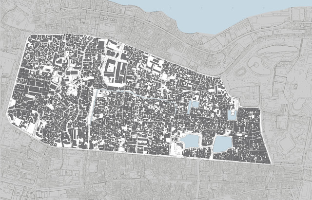
The rapidly developing city of Hanoi is a fascinating source of study models for architects, geographers, and urban-development researchers. The architect Philippe Lê uses the compact, relatively affordable, and autonomous technology of a remote-controlled aerial vehicle (drone), mounted with a small digital camera,[5] to capture images he uses to study an archetypal neighborhood. Lê says his purpose is to understand the complexity of the urban fabric: “As it was created spontaneously, the usual municipal plans or official urban documents do not show the reality with all its richness — therefore an aerial survey of the real existing conditions is necessary.”[6] (Fig. 2) Newly available equipment is well suited for his purpose of researching — and documenting — urban building models he has identified in the Ngoc Ha neighborhood of central Hanoi in order to reveal the intricacy and beauty of this dense matrix. (Fig. 3)
Lê explains his decision to view the area from above: “The ideal vantage point to understand the complexity of a city,” he says, “is from the air. It allows a revealing of structures, ways, and construction that, for many, are not accessible from the ground or are closed to any public access. It shows all the richness, and layers of complexity, that a simple walk through would not be able to embrace. Especially when the city is informally generated without any precise plan or urban design.”[7]
His process involves taking high-resolution aerial shots in a densely built area and then merging all the images as one large, very-high-resolution projection of the city block. The whole neighborhood is then mapped by directly going, on the ground, into each street, passage, and path using this high-resolution image as a background reference. Once the complete street network is mapped and compared to plans obtained from the municipality, all houses and constructions are added — based, once again, on the aerial survey. All of this information is integrated into a geographic information system (GIS) database so that more information/metadata for each feature can be added either by himself or others interested in contributing to this project.
“Ngoc Ha is clearly identifiable by four main roads separating it from the rest of the urban fabric,” Philippe Lê says, “which makes it . . . an ideal case study. It is also a very mixed area with poor, rich, farmers, industries . . . living and working together creating a social diversity that could be an example for future cities.”[8]
Philippe Lê grew up in Paris and graduated with honors from École d’architecture Paris-Villemin. He practiced architecture in Paris for fifteen years before moving to Hanoi, in 2011, to participate in the architectural development of that city. Drawn to the seemingly chaotic assemblage of buildings in the alleys surrounding his Hanoi residence, his explorations led him to focus on the appeal of the unique features contained within this densely built, multigenerational, single-family, mixed-use urban neighborhood accessible by narrow (pedestrian, bicycle, motorbike) alleyways.
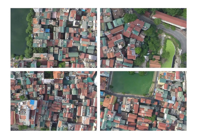
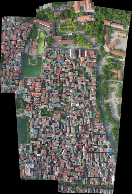
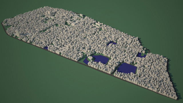
Not satisfied with what he could see at street level or from the occasionally accessed terrace, and with no up-to-date surveyor’s maps, he determined that flying over with a camera on a drone would reveal some of the mystery. Indeed, the view from above confirmed the complexity of typologies that come from an example of informal housing solutions undertaken in an environment of rapid transformation. From a set of images captured (Fig. 4), approximately six hundred were selected, assembled, and stitched together to form a high-resolution vertical survey (Fig. 5). Other, non-vertical views helped to clarify the volumetry and building height and together form a final 3D model integrating the vertical (plan) and volumetric information (Fig. 6).
“Capturing the view of the urban fabric from above helps to understand the volume of the city,” says Lê. “It gives a third dimension to the place and makes the complexity of the superposition of functions and roles more understandable. It also reveals the beauty of the city from this viewpoint and adds a touch of the spectacular that is usually not accessible.”[9] (Fig. 7)
Analyzing the features of this model may inspire considerations for future built environments that respect qualities of life enjoyed by a population and direct attention to aspects that would require improvement: safety (access by emergency and sanitation vehicles; fire-hazard reduction; efficiency (in access, circulation, and maintenance); and longevity (in quality of construction), for example.
“Visualizing density is not merely an ocular undertaking, but also an intellectual understanding of how density is generated (formally, socially, and economically) and why.”[10]
To understand how this neighborhood was formed requires a brief look at Hanoi’s urban development and Ngoc Ha’s position within it. Following a westward path from the city center toward the former village is like taking a guided tour through Hanoi’s history — and the expansion of the city — by linking the landmark sites, all of which draw both national and foreign visitors.
Originally an agricultural village, primarily growing flowers and medicinal plants to supply traders in the city center, most of the area has been subsumed by the urban fabric, as can be seen if one walks through the Ngoc Ha district today. For the uninitiated, traces of the former floricultural village are now difficult to find. The once east–west flowing namesake Pearl River (Ngoc Ha), which connected the village to the market, remains only in name; it was, like other numerous waterways in Hanoi, covered up by development in the early twentieth century. The gate framing the lane to the Ngoc Ha neighborhood is easy to overlook for the thick tangle of overhanging electrical wires leading off the nearby transformer. More eye-catching is the recently restored and expanded dinh (community house). Indeed, the modest marker of the gate is not very old, as longtime residents will laughingly confide, but it gives an air of historical value to the labyrinth of lanes behind it.
Characterized by its step-by-step transformation from village to residential neighborhood to urban quarter, the practice of appropriating space to expand living spaces was in Hanoi always a fact, reaching back to the Chinese colonial period and through the French colonial period, although it became more vigorously undertaken by both the state, and residents, with the Collectivist Era and the mid-century rural exodus. Appropriation of unbuilt areas to expand — or transform — living spaces was practiced by both the state and citizens. Community spaces, pagodas, and community houses were likewise requisitioned for families during the housing crisis of 1960–74, during which the population of Hanoi doubled. When the state recognized that it could not build sufficient quantities of housing for the influx of people through planned development, it rolled out the policy “the state and the people build together,” supplying electricity and sewage services to individual initiatives formerly considered to be unlawful self-build.[11] In 1981, the central municipality designated Ngoc Ha village as an urban district within the Ba Dinh ward (phường) of Hanoi managed by community associations.[12]
Densification in Ngoc Ha occurred mostly after 1990, when residents, of various income levels and resources, built on and between existent structures and within a framework that the scholar Stephanie Geertman describes as nonconfrontational tactics for informal housing development. Prevailing ambiguity in building laws and land ownership enabled a space for negotiation, once the solidarity of neighbors was secured, with neighborhood representatives, who in turn could appeal to the municipality on behalf of the citizen. The state provided further support through the ability to legally register an informally developed residence built pre-2004.[13]
Lifestyles, social networks, and roles were brought along in these transitions from rural to urban, which include self-building practices.[14] The behavioral scientist Thomas Talhelm has proposed that the interdependence of labor-intensive rice farmers has supplied those populations with a cultural trait whereby smooth relations with neighbors is key to community living.[15] Ngoc Ha neighborhood is a model of informally led coordination resulting in densification rather than market-led development infill (Fig. 8). This type of urban densification is common in central Hanoi, although it may seem incomprehensible to individualistic-oriented societies.
“Photographed images don’t seem to be statements about the world so much as pieces of it, miniatures that anyone can make or acquire.”[16]
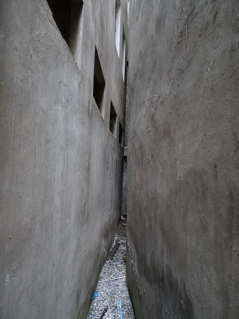
The drone-based camera is a meaningful tool in the acquisition of these “miniatures.” At this level of research, the objective is for gathering volumetric data. Regulations on high-altitude air photography by defense ministries, which may have created conflicts or brought up issues of surveillance (either with the military or with residents), were avoided as much as possible by maintaining a deliberately noninvasive (high but not too high) distance. Although it could be possible for the relatively small drone to pass through narrow passageways at building level, the dangers of this maneuver, beyond issues of privacy, were quickly identified: entanglement with haphazardly strung electrical wires, jutting balcony gardens, and other hanging accoutrements ubiquitous in most Hanoi neighborhoods (Fig. 9). The elements required to facilitate assembling and modeling the images for study were necessarily structures that could not be seen from ground level. To better understand the volumes of this “world” (Ngoc Ha), it was necessary to look from as many angles as possible and to “acquire” the pieces that compose it.
Philippe Lê’s images capture the physicality and materiality of architecture, using an intricate assemblage of interlocking, closely knit visual interconnections, and overlapping of components, which further echo the reality existing within this neighborhood. His fly-over images of buildings, homes, gardens, and other spaces are non-invasive yet present the friction and dynamic of aesthetics and personalities sharing urban space where the notion of public and private have not yet become as fixed or static as in some other cultures.[17]
His bird’s-eye view captures an ensemble image of this neighborhood that could inspire other researchers to explore in-depth issues related to urban culture and society. Indeed, although his drone-captured, high-resolution images were not initially intended as historical or documentary photography beyond his own area of research, Philippe Lê is often contacted by other researchers and publishers for permission to use them in documentaries and publications about Hanoi.[18]
The purpose of this essay is to focus on the use of drone photography as a tool for architects studying features of a specific urban land area. The example of Ngoc Ha neighborhood demonstrates the legibility of the encroachment of an urban fabric and its transition from rural to urban. The images captured by Philippe Lê’s low-flying drones serve as valuable illustrations for himself and other researchers who share the objective of describing the richness of the models found here and use the technology as a basis for making visible the way that modern city development integrates the complexity of informal construction. Continued advocacy for using small drones responsibly is necessary so that the innovative purposes for which small drones can be used are recognized by the public and policymakers. And studies like Philippe Lê’s contribute to a clearer understanding of what makes drone technology exciting and efficient for communicating about urban form and space.
Monique Gross is an American/French independent writer, architectural photographer and translator who has lived and worked in Paris and Hanoi. Currently she is engaged in research about the modern architectural development of Abu Dhabi.
Roseau, Nathalie. “The City Seen from the Aeroplane, Distorted Reflections and Urban Futures,” in Seeing from Above: The Aerial View in Visual Culture. Mark Dorrian and Frédéric Pousin, eds. London: I.B.Tauris, 2013, p. 212.

Boucher, Philip. “Domesticating the Drone: The Demilitarisation of Unmanned Aircraft for Civil Markets,” in Science and Engineering Ethics 21 (2015), 1393–1412. DOI 10.1007/s1194860146960363

Busta, Hallie. “Can I (Legally) Use a Drone?” in Architect, Journal of the American Institute of Architects, 21 May 2015. http://www.architectmagazine.com/technology/can-i-legally-use-a-drone_o. Accessed 18 September, 2016.

Guillot, Craig. “Drone’s Eye View: The Ups and Downs of Using this New Technology,” in Journal of the American Planning Association October 2015, pp. 31–33.

Lê used a quad-rotor, remote-controlled Dji Phantom 2 (diagonal measurement of 350 m and weight of 1000 g (http://www.dji.com/phantom-2) fitted with a GoPro3 camera. This recreational drone has a communication distance of 1,000 meters and a relatively short flight time of 25 minutes. These factors, along with an advantageous altitude, made it such that Le was always controlling the drone from a rooftop where he could keep his eye on it.

Michael A. Larice in his review of Visualizing Density, by Julie Campoli and Alex S. MacLean. Cambridge, MA: Lincoln Institute of Land Policy, 2007, p. 101.

Fanchette, Sylvie, ed. Ha Noi, a Metropolis in the Making: The Breakdown in Urban Integration of Villages. IRD Editions, 2016.

Geertman, Stephanie, and Boram Kim. “Hanoi: A Study of Informally Developed Housing and Its Role in the Political Arena of a Post-Reform Socialist City,” in Informal Urbanisation. Routledge, forthcoming.

Cerise, E., et al. “The Expansion of the City through Integration of Urban Villages.” Ha Noi, a Metropolis in the Making: The Breakdown in Urban Integration of Villages. Sylvie Fanchette, ed. IRD Editions, 2016.

Talhelm, Thomas, et al. “Large-Scale Psychological Differences Within China Explained by Rice Versus Wheat Agriculture” Science, vol. 344, issue 6184 2014, 603–608. DOI: 10.1126/science.1246850. http://science.sciencemag.org/content/344/6184/603.abstract

Sontag, Susan. On Photography. New York: Farrar, Straus and Giroux, 1973, p. 2.

For insight into factors historically guiding concepts of public and private space in Hanoi, see Logan, William S. Hanoi: Biography of a City. Sydney, Canberra: University of New South Wales Press Ltd, 2000.

Images from his collection appear in, for example, the trilingual photobook Ha Noi Capital City, edited by Dr. Michael Waibel, a German researcher and senior lecturer on urban development in Southeast Asia at the University of Hamburg; articles by the researcher on urban development in Vietnam Stephanie Geertman; Ha Noi, a Metropolis in the Making: The Breakdown in Urban Integration of Villages, edited Sylvie Fanchette, a French scholar of urbanization; and the documentary The Vanishing Village, by Dr. John G. Kleine, the Dutch researcher on the history of Vietnam and senior adviser to EU Asia. For inquiries about using Lê's images, contact ple@ple-architecture.eu or Noi Pictures: http://www.noipictures.com/


