Report of the governor general of the Philippine Islands. [1908]
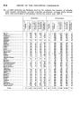
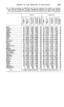
546 REPORT OF THE PHILIPPINE COMMISSION. soundings and tidal observations. This work was completed on the 25th, and on the following day she sailed for Mercedes, where she arrived on the 27th; the next day coaled ship and located three new buoys recently placed in the mouth of the Daet River. On the 29th she proceeded to Capalonga and erected an automatic tide gauge in the estuary of that river and on the following day sailed for Atimonan, where the triangulation was taken up to connect the main scheme, which was brought across the divide from the west side of Luzon, with the triangulation of Lamon Bay and again with the triangulation of Calaguas Islands. Almost continuous cloudy and rainy weather interfered with the use of heliotropes, which were required on all the lines, and a great deal of steaming was demanded of the ship to keep all parties moving, but the connection was completed before the end of June and we now have a continuous scheme of triangulation from the north coast of Luzon to the southern extremity of Samar. The tidal observations show a gratifying improvement in quality since a regular tidal observer has been employed. Heretofore it had been the custom to detail one of the seamen of the vessel for that purpose, and the results were far from satisfactory. STEAMER " MARINDUQUE." Was in Manila repairing and outfitting from July 1 to 9, and on the 10th Sailed for the east coast of Luzon, where she arrived on the 14th, and took up General surveys of Lamon Bay and vicinity in continuation of the work of the previous year. The triangulation was taken up in the vicinity of Alabat and Atimonan and carried around the southern end of Lamon Bay and out Calauag Bay to Pangao Point. The topography was completed around the shore of Luzon from Atimonan to 1)agdap, also along the shore of Alabat Island from Muel around the south end of the island and up the eastern shore to Gerado Point, where it connected with the work of the preceding year. She also made a survey of Balesin Island. The hydrography included the south end of Lamon Bay, Calauag Bay, and was extended out to Dagdap Point, Balesin and Cabaleto islands. The season was closed on October 13 and the vessel sailed for Manila, where she arrived on the 15th and was engaged repairing and outfitting until the 22nd, when she sailed for Palompon, Leyte, where she arrived on the 24th, and on the following day resumed the general surveys between Cebu and Leyte and extended it northward from the previous work in that vicinity. The triangulation was started from the line " Bulalaqui" to "Malcamko" and carried around the northern extremity of Cebu Island and into the northern entrance of Tanon Strait, ending on the line " Escalante" to " Putad" and also around the north end of Leyte Island and through Biliran Strait into Carigara Bay. The topography was completed along the east coast of Cebu from Bantulin to Campatoc Point, along the west coast of Leyte from Villaba around Rabin Point, through Biliran Strait into Carigara Bay, and also around the south and west shore of Biliran Island from Matuntun Point to Tincansan Island. The hydrography included the area between Cebu and Leyte, from Bantulin and Duljugan points on the south to the northwest end of Biliran Island and through Biliran Strait into Carigara Bay. Field work was closed in this vicinity on April 2, and the vessel arrived in Manila on the 4th, where she remained for repairs, outfitting and compiling their records and reports until May 18, when she sailed for the eastern coast of Luzon, arriving at Atimonan on the 22d. Field work was immediately commenced, but stormy weather prevailed during the remainder of the month, and the completion of one topographic sheet and some signal building was all that could be accomplished. The month of June, however, was much more favorable for field work and the triangulation between Polillo and Luzon, four topographic sheets having been completed. Numerous difficulties were encountered in advancing the triangulation. At some of the stations four or five days' clearing was required. Four scaffold signals had to be erected and this consumed considerable time, the heights of these scaffolds being 30, 40, and 150 feet, approximately. Whenever possible a large tree 4 or 5 feet in diameter at the base was selected as a center, these trees being often over 150 feet high and very straight, with few branches. They were sawed off as high up as possible and the theodolite mounted on top. Around the tree, and entirely free from it, a quadrilateral scaffold was built for the observer to walk on, so as not to jar the instrument. The triangle clos
-
Scan 1

Page #1
-
Scan 2

Page #2
-
Scan 3

Page #3
-
Scan 4

Page #4
-
Scan 5

Page I
-
Scan 6

Page II
-
Scan 7

Page III - Table of Contents
-
Scan 8

Page IV - Table of Contents
-
Scan 9

Page V - Table of Contents
-
Scan 10

Page VI - Table of Contents
-
Scan 11

Page VII - Table of Contents
-
Scan 12
Page VIII - Table of Contents
-
Scan 13

Page 1
-
Scan 14

Page 2
-
Scan 15

Page 3
-
Scan 16

Page 4
-
Scan 17

Page 5
-
Scan 18
Page 6
-
Scan 19

Page 7
-
Scan 20

Page 8
-
Scan 21

Page 9
-
Scan 22

Page 10
-
Scan 23

Page 11
-
Scan 24

Page 12
-
Scan 25

Page 13
-
Scan 26

Page 14
-
Scan 27

Page 15
-
Scan 28

Page 16
-
Scan 29

Page 17
-
Scan 30

Page 18
-
Scan 31

Page 19
-
Scan 32

Page 20
-
Scan 33

Page 21
-
Scan 34

Page 22
-
Scan 35

Page 23
-
Scan 36

Page 24
-
Scan 37

Page 25
-
Scan 38

Page 26
-
Scan 39

Page 27
-
Scan 40

Page 28
-
Scan 41

Page 29
-
Scan 42

Page 30
-
Scan 43

Page 31
-
Scan 44

Page 32
-
Scan 45

Page 33
-
Scan 46

Page 34
-
Scan 47

Page 35
-
Scan 48

Page 36
-
Scan 49

Page 37
-
Scan 50

Page 38
-
Scan 51

Page 39
-
Scan 52

Page 40
-
Scan 53

Page 41
-
Scan 54

Page 42
-
Scan 55

Page 43
-
Scan 56

Page 44
-
Scan 57

Page 45
-
Scan 58

Page 46
-
Scan 59

Page 47
-
Scan 60

Page 48
-
Scan 61

Page 49
-
Scan 62

Page 50
-
Scan 63

Page 51
-
Scan 64

Page 52
-
Scan 65

Page 53
-
Scan 66

Page 54
-
Scan 67

Page 55
-
Scan 68

Page 56
-
Scan 69

Page 57
-
Scan 70

Page 58
-
Scan 71

Page 59
-
Scan 72

Page 60
-
Scan 73

Page 61
-
Scan 74

Page 62
-
Scan 75

Page 63
-
Scan 76

Page 64
-
Scan 77

Page 65
-
Scan 78

Page 66
-
Scan 79

Page 67
-
Scan 80

Page 68
-
Scan 81

Page 69
-
Scan 82

Page 70
-
Scan 83

Page 71
-
Scan 84

Page 72
-
Scan 85

Page 73
-
Scan 86

Page 74
-
Scan 87

Page 75
-
Scan 88

Page 76
-
Scan 89

Page 77
-
Scan 90

Page 78
-
Scan 91

Page 79
-
Scan 92

Page 80
-
Scan 93

Page 81
-
Scan 94

Page 82
-
Scan 95

Page 83
-
Scan 96

Page 84
-
Scan 97

Page 85
-
Scan 98

Page 86
-
Scan 99

Page 87
-
Scan 100

Page 88
-
Scan 101

Page 89
-
Scan 102

Page 90
-
Scan 103

Page 91
-
Scan 104

Page 92
-
Scan 105

Page 93
-
Scan 106

Page 94
-
Scan 107

Page 95
-
Scan 108

Page 96
-
Scan 109

Page 97
-
Scan 110

Page 98
-
Scan 111

Page 99
-
Scan 112
Page 100
-
Scan 113

Page 101
-
Scan 114

Page 102
-
Scan 115

Page 103
-
Scan 116

Page 104
-
Scan 117

Page 105
-
Scan 118
Page 106
-
Scan 119
Page 107
-
Scan 120

Page 108
-
Scan 121

Page 109
-
Scan 122

Page 110
-
Scan 123

Page 111
-
Scan 124

Page 112
-
Scan 125

Page 113
-
Scan 126

Page 114
-
Scan 127

Page 115
-
Scan 128

Page 116
-
Scan 129

Page 117
-
Scan 130

Page 118
-
Scan 131

Page 119
-
Scan 132

Page 120
-
Scan 133

Page 121
-
Scan 134

Page 122
-
Scan 135

Page 123
-
Scan 136

Page 124
-
Scan 137

Page 125
-
Scan 138

Page 126
-
Scan 139

Page 127
-
Scan 140

Page 128
-
Scan 141

Page #141
-
Scan 142

Page #142
-
Scan 143

Page #143
-
Scan 144

Page #144
-
Scan 145

Page #145
-
Scan 146

Page #146
-
Scan 147

Page #147
-
Scan 148

Page #148
-
Scan 149

Page #149
-
Scan 150

Page #150
-
Scan 151

Page #151
-
Scan 152

Page #152
-
Scan 153

Page 129
-
Scan 154

Page 130
-
Scan 155

Page 131
-
Scan 156

Page 132
-
Scan 157

Page 133
-
Scan 158
Page 134
-
Scan 159

Page 135
-
Scan 160

Page 136
-
Scan 161

Page 137
-
Scan 162

Page 138
-
Scan 163

Page 139
-
Scan 164

Page 140
-
Scan 165

Page 141
-
Scan 166

Page 142
-
Scan 167

Page 143
-
Scan 168

Page 144
-
Scan 169

Page 145
-
Scan 170

Page 146
-
Scan 171

Page 147
-
Scan 172

Page 148
-
Scan 173

Page 149
-
Scan 174

Page 150
-
Scan 175

Page 151
-
Scan 176

Page 152
-
Scan 177

Page 153
-
Scan 178

Page 154
-
Scan 179

Page 155
-
Scan 180

Page 156
-
Scan 181

Page 157
-
Scan 182

Page 158
-
Scan 183
Page 159
-
Scan 184

Page 160
-
Scan 185

Page 161
-
Scan 186

Page 162
-
Scan 187
Page 163
-
Scan 188

Page 164
-
Scan 189

Page 165
-
Scan 190

Page 166
-
Scan 191

Page 167
-
Scan 192

Page 168
-
Scan 193

Page 169
-
Scan 194

Page 170
-
Scan 195

Page 171
-
Scan 196

Page 172
-
Scan 197

Page 173
-
Scan 198

Page 174
-
Scan 199

Page 175
-
Scan 200

Page 176
-
Scan 201

Page 177
-
Scan 202

Page 178
-
Scan 203

Page 179
-
Scan 204

Page 180
-
Scan 205

Page 181
-
Scan 206

Page 182
-
Scan 207

Page 183
-
Scan 208

Page 184
-
Scan 209
Page 185
-
Scan 210

Page 186
-
Scan 211

Page 187
-
Scan 212

Page 188
-
Scan 213

Page 189
-
Scan 214

Page 190
-
Scan 215

Page 191
-
Scan 216

Page 192
-
Scan 217

Page 193
-
Scan 218

Page 194
-
Scan 219

Page 195
-
Scan 220

Page 196
-
Scan 221

Page 197
-
Scan 222

Page 198
-
Scan 223

Page 199
-
Scan 224

Page 200
-
Scan 225

Page 201
-
Scan 226

Page 202
-
Scan 227

Page 203
-
Scan 228

Page 204
-
Scan 229

Page 205
-
Scan 230

Page 206
-
Scan 231

Page 207
-
Scan 232

Page 208
-
Scan 233

Page 209
-
Scan 234

Page 210
-
Scan 235

Page 211
-
Scan 236

Page 212
-
Scan 237
Page 213
-
Scan 238

Page 214
-
Scan 239

Page 215
-
Scan 240

Page 216
-
Scan 241

Page 217
-
Scan 242

Page 218
-
Scan 243

Page 219
-
Scan 244

Page 220
-
Scan 245

Page 221
-
Scan 246

Page 222
-
Scan 247
Page 223
-
Scan 248

Page 224
-
Scan 249

Page 225
-
Scan 250

Page 226
-
Scan 251

Page 227
-
Scan 252

Page 228
-
Scan 253

Page 229
-
Scan 254

Page 230
-
Scan 255

Page 231
-
Scan 256
Page 232
-
Scan 257

Page 233
-
Scan 258
Page 234
-
Scan 259

Page 235
-
Scan 260

Page 236
-
Scan 261

Page 237
-
Scan 262

Page 238
-
Scan 263

Page 239
-
Scan 264

Page 240
-
Scan 265

Page 241
-
Scan 266

Page 242
-
Scan 267

Page 243
-
Scan 268

Page 244
-
Scan 269

Page 245
-
Scan 270

Page 246
-
Scan 271

Page 247
-
Scan 272

Page 248
-
Scan 273

Page 249
-
Scan 274

Page 250
-
Scan 275

Page 251
-
Scan 276
Page 252
-
Scan 277

Page 253
-
Scan 278

Page 254
-
Scan 279

Page 255
-
Scan 280

Page 256
-
Scan 281

Page 257
-
Scan 282

Page 258
-
Scan 283

Page 259
-
Scan 284

Page 260
-
Scan 285

Page 261
-
Scan 286

Page 262
-
Scan 287

Page 263
-
Scan 288

Page 264
-
Scan 289

Page 265
-
Scan 290

Page 266
-
Scan 291

Page 267
-
Scan 292

Page 268
-
Scan 293

Page 269
-
Scan 294

Page 270
-
Scan 295

Page 271
-
Scan 296

Page 272
-
Scan 297

Page 273
-
Scan 298

Page 274
-
Scan 299

Page 275
-
Scan 300

Page 276
-
Scan 301

Page 277
-
Scan 302

Page 278
-
Scan 303

Page 279
-
Scan 304

Page 280
-
Scan 305

Page 281
-
Scan 306

Page 282
-
Scan 307

Page 283
-
Scan 308

Page 284
-
Scan 309

Page 285
-
Scan 310

Page 286
-
Scan 311

Page 287
-
Scan 312

Page 288
-
Scan 313

Page 289
-
Scan 314

Page 290
-
Scan 315

Page 291
-
Scan 316
Page 292
-
Scan 317

Page 293
-
Scan 318

Page 294
-
Scan 319

Page 295
-
Scan 320

Page 296
-
Scan 321

Page 297
-
Scan 322
Page 298
-
Scan 323

Page 299
-
Scan 324

Page 300
-
Scan 325

Page 301
-
Scan 326

Page 302
-
Scan 327

Page 303
-
Scan 328

Page 304
-
Scan 329

Page 305
-
Scan 330

Page 306
-
Scan 331

Page 307
-
Scan 332

Page 308
-
Scan 333

Page 309
-
Scan 334

Page 310
-
Scan 335

Page 311
-
Scan 336

Page 312
-
Scan 337

Page 313
-
Scan 338

Page 314
-
Scan 339

Page 315
-
Scan 340

Page 316
-
Scan 341

Page 317
-
Scan 342

Page 318
-
Scan 343

Page 319
-
Scan 344

Page 320
-
Scan 345

Page 321
-
Scan 346

Page 322
-
Scan 347
Page 323
-
Scan 348

Page 324
-
Scan 349

Page 325
-
Scan 350

Page 326
-
Scan 351

Page 327
-
Scan 352

Page 328
-
Scan 353

Page 329
-
Scan 354

Page 330
-
Scan 355

Page 331
-
Scan 356

Page 332
-
Scan 357

Page 333
-
Scan 358

Page 334
-
Scan 359

Page 335
-
Scan 360

Page 336
-
Scan 361

Page 337
-
Scan 362

Page 338
-
Scan 363

Page 339
-
Scan 364

Page 340
-
Scan 365

Page 341
-
Scan 366

Page 342
-
Scan 367

Page 343
-
Scan 368

Page 344
-
Scan 369

Page 345
-
Scan 370

Page 346
-
Scan 371
Page 347
-
Scan 372

Page 348
-
Scan 373

Page 349
-
Scan 374

Page 350
-
Scan 375

Page 351
-
Scan 376

Page 352
-
Scan 377

Page 353
-
Scan 378

Page 354
-
Scan 379

Page 355
-
Scan 380

Page 356
-
Scan 381

Page 357
-
Scan 382

Page 358
-
Scan 383

Page 359
-
Scan 384

Page 360
-
Scan 385

Page 361
-
Scan 386

Page 362
-
Scan 387

Page 363
-
Scan 388

Page 364
-
Scan 389

Page 365
-
Scan 390

Page 366
-
Scan 391

Page 367
-
Scan 392

Page 368
-
Scan 393

Page 369
-
Scan 394

Page 370
-
Scan 395

Page 371
-
Scan 396

Page 372
-
Scan 397

Page 373
-
Scan 398

Page 374
-
Scan 399

Page 375
-
Scan 400

Page 376
-
Scan 401

Page 377
-
Scan 402

Page 378
-
Scan 403

Page 379
-
Scan 404

Page 380
-
Scan 405

Page 381
-
Scan 406

Page 382
-
Scan 407

Page 383
-
Scan 408

Page 384
-
Scan 409
Page 385
-
Scan 410

Page 386
-
Scan 411

Page 387
-
Scan 412

Page 388
-
Scan 413

Page 389
-
Scan 414

Page 390
-
Scan 415

Page 391
-
Scan 416

Page 392
-
Scan 417

Page 393
-
Scan 418

Page 394
-
Scan 419

Page 395
-
Scan 420

Page 396
-
Scan 421

Page 397
-
Scan 422

Page 398
-
Scan 423

Page 399
-
Scan 424

Page 400
-
Scan 425

Page 401
-
Scan 426

Page 402
-
Scan 427

Page 403
-
Scan 428

Page 404
-
Scan 429

Page 405
-
Scan 430

Page 406
-
Scan 431
Page 407
-
Scan 432

Page 408
-
Scan 433

Page 409
-
Scan 434

Page 410
-
Scan 435

Page 411
-
Scan 436

Page 412
-
Scan 437

Page 413
-
Scan 438

Page 414
-
Scan 439

Page 415
-
Scan 440

Page 416
-
Scan 441

Page 417
-
Scan 442

Page 418
-
Scan 443

Page 419
-
Scan 444

Page 420
-
Scan 445

Page 421
-
Scan 446

Page 422
-
Scan 447

Page 423
-
Scan 448

Page 424
-
Scan 449

Page 425
-
Scan 450

Page 426
-
Scan 451

Page 427
-
Scan 452

Page 428
-
Scan 453

Page 429
-
Scan 454

Page 430
-
Scan 455

Page 431
-
Scan 456

Page 432
-
Scan 457

Page 433
-
Scan 458

Page 434
-
Scan 459

Page 435
-
Scan 460

Page 436
-
Scan 461

Page 437
-
Scan 462

Page 438
-
Scan 463

Page 439
-
Scan 464

Page 440
-
Scan 465

Page 441
-
Scan 466

Page 442
-
Scan 467

Page 443
-
Scan 468

Page 444
-
Scan 469

Page 445
-
Scan 470

Page 446
-
Scan 471

Page 447
-
Scan 472

Page 448
-
Scan 473

Page 449
-
Scan 474

Page 450
-
Scan 475

Page 451
-
Scan 476

Page 452
-
Scan 477

Page 453
-
Scan 478

Page 454
-
Scan 479

Page 455
-
Scan 480

Page 456
-
Scan 481

Page 457
-
Scan 482

Page 458
-
Scan 483

Page 459
-
Scan 484

Page 460
-
Scan 485

Page 461
-
Scan 486

Page 462
-
Scan 487

Page 463
-
Scan 488

Page 464
-
Scan 489

Page 465
-
Scan 490

Page 466
-
Scan 491

Page 467
-
Scan 492

Page 468
-
Scan 493

Page 469
-
Scan 494

Page 470
-
Scan 495

Page 471
-
Scan 496

Page 472
-
Scan 497

Page 473
-
Scan 498

Page 474
-
Scan 499

Page 475
-
Scan 500

Page 476
-
Scan 501

Page 477
-
Scan 502

Page 478
-
Scan 503
Page 479
-
Scan 504

Page 480
-
Scan 505

Page #505
-
Scan 506

Page #506
-
Scan 507

Page #507
-
Scan 508

Page #508
-
Scan 509

Page 481
-
Scan 510

Page 482
-
Scan 511

Page 483
-
Scan 512

Page 484
-
Scan 513

Page 485
-
Scan 514

Page 486
-
Scan 515

Page 487
-
Scan 516

Page 488
-
Scan 517

Page 489
-
Scan 518

Page 490
-
Scan 519

Page 491
-
Scan 520

Page 492
-
Scan 521

Page 493
-
Scan 522

Page 494
-
Scan 523

Page 495
-
Scan 524

Page 496
-
Scan 525

Page 497
-
Scan 526

Page 498
-
Scan 527

Page 499
-
Scan 528

Page 500
-
Scan 529

Page 501
-
Scan 530

Page 502
-
Scan 531

Page 503
-
Scan 532

Page 504
-
Scan 533

Page 505
-
Scan 534

Page 506
-
Scan 535

Page 507
-
Scan 536

Page 508
-
Scan 537

Page 509
-
Scan 538

Page 510
-
Scan 539

Page 511
-
Scan 540

Page 512
-
Scan 541

Page 513
-
Scan 542

Page 514
-
Scan 543

Page 515
-
Scan 544

Page 516
-
Scan 545

Page 517
-
Scan 546

Page 518
-
Scan 547

Page 519
-
Scan 548

Page 520
-
Scan 549

Page 521
-
Scan 550

Page 522
-
Scan 551

Page 523
-
Scan 552

Page 524
-
Scan 553

Page 525
-
Scan 554

Page 526
-
Scan 555

Page 527
-
Scan 556

Page 528
-
Scan 557

Page 529
-
Scan 558

Page 530
-
Scan 559

Page 531
-
Scan 560

Page 532
-
Scan 561

Page 533
-
Scan 562

Page 534
-
Scan 563

Page 535
-
Scan 564

Page 536
-
Scan 565

Page 537
-
Scan 566

Page 538
-
Scan 567
Page 539
-
Scan 568

Page 540
-
Scan 569

Page 541
-
Scan 570

Page 542
-
Scan 571

Page 543
-
Scan 572

Page 544
-
Scan 573
Page 545
-
Scan 574

Page 546
-
Scan 575

Page 547
-
Scan 576

Page 548
-
Scan 577

Page 549
-
Scan 578

Page 550
-
Scan 579

Page 551
-
Scan 580

Page 552
-
Scan 581

Page 553
-
Scan 582

Page 554
-
Scan 583

Page 555
-
Scan 584

Page 556
-
Scan 585

Page 557
-
Scan 586

Page 558
-
Scan 587

Page 559
-
Scan 588

Page 560
-
Scan 589

Page 561
-
Scan 590

Page 562
-
Scan 591

Page 563
-
Scan 592

Page 564
-
Scan 593

Page 565
-
Scan 594

Page 566
-
Scan 595

Page 567
-
Scan 596

Page 568
-
Scan 597

Page 569
-
Scan 598

Page 570
-
Scan 599

Page 571
-
Scan 600

Page 572
-
Scan 601

Page 573
-
Scan 602

Page 574
-
Scan 603

Page 575
-
Scan 604

Page 576
-
Scan 605

Page 577
-
Scan 606

Page 578
-
Scan 607

Page 579
-
Scan 608

Page 580
-
Scan 609

Page 581
-
Scan 610

Page 582
-
Scan 611

Page 583
-
Scan 612

Page 584
-
Scan 613

Page 585
-
Scan 614

Page 586
-
Scan 615

Page 587
-
Scan 616

Page 588
-
Scan 617

Page 589
-
Scan 618

Page 590
-
Scan 619

Page 591
-
Scan 620

Page 592
-
Scan 621

Page 593
-
Scan 622

Page 594
-
Scan 623

Page 595
-
Scan 624

Page 596
-
Scan 625

Page 597
-
Scan 626

Page 598
-
Scan 627

Page 599
-
Scan 628

Page 600
-
Scan 629

Page 601
-
Scan 630

Page 602
-
Scan 631

Page 603
-
Scan 632

Page 604
-
Scan 633

Page 605
-
Scan 634

Page 606
-
Scan 635

Page 607
-
Scan 636

Page 608
-
Scan 637

Page 609
-
Scan 638

Page 610
-
Scan 639

Page 611
-
Scan 640

Page 612
-
Scan 641

Page 613
-
Scan 642

Page 614
-
Scan 643

Page 615
-
Scan 644

Page 616
-
Scan 645

Page 617
-
Scan 646

Page 618
-
Scan 647
Page 619
-
Scan 648

Page 620
-
Scan 649

Page 621
-
Scan 650

Page 622
-
Scan 651

Page 623
-
Scan 652

Page 624
-
Scan 653

Page 625
-
Scan 654

Page 626
-
Scan 655
Page 627
-
Scan 656

Page 628
-
Scan 657

Page 629
-
Scan 658

Page 630
-
Scan 659

Page 631
-
Scan 660

Page 632
-
Scan 661

Page 633
-
Scan 662

Page 634
-
Scan 663

Page 635
-
Scan 664

Page 636
-
Scan 665

Page 637
-
Scan 666

Page 638
-
Scan 667

Page 639
-
Scan 668

Page 640
-
Scan 669

Page 641
-
Scan 670

Page 642
-
Scan 671

Page 643
-
Scan 672

Page 644
-
Scan 673

Page 645
-
Scan 674

Page 646
-
Scan 675

Page 647
-
Scan 676

Page 648
-
Scan 677

Page 649
-
Scan 678

Page 650
-
Scan 679

Page 651
-
Scan 680

Page 652
-
Scan 681

Page 653
-
Scan 682

Page 654
-
Scan 683

Page 655
-
Scan 684

Page 656
-
Scan 685

Page 657
-
Scan 686

Page 658
-
Scan 687

Page 659
-
Scan 688

Page 660
-
Scan 689

Page 661
-
Scan 690

Page 662
-
Scan 691

Page 663
-
Scan 692

Page 664
-
Scan 693

Page 665
-
Scan 694

Page 666
-
Scan 695

Page 667
-
Scan 696

Page 668
-
Scan 697

Page 669
-
Scan 698

Page 670
-
Scan 699

Page 671
-
Scan 700

Page 672
-
Scan 701

Page 673
-
Scan 702

Page 674
-
Scan 703

Page 675
-
Scan 704

Page 676
-
Scan 705

Page 677
-
Scan 706

Page 678
-
Scan 707
Page 679
-
Scan 708

Page 680
-
Scan 709

Page 681
-
Scan 710

Page 682
-
Scan 711

Page 683
-
Scan 712

Page 684
-
Scan 713

Page 685
-
Scan 714

Page 686
-
Scan 715

Page 687
-
Scan 716

Page 688
-
Scan 717

Page 689
-
Scan 718

Page 690
-
Scan 719

Page 691
-
Scan 720

Page 692
-
Scan 721

Page 693
-
Scan 722

Page 694
-
Scan 723

Page 695
-
Scan 724

Page 696
-
Scan 725

Page 697
-
Scan 726

Page 698
-
Scan 727

Page 699
-
Scan 728

Page 700
-
Scan 729

Page 701
-
Scan 730

Page 702
-
Scan 731

Page 703
-
Scan 732

Page 704
-
Scan 733

Page 705
-
Scan 734

Page 706
-
Scan 735

Page 707
-
Scan 736

Page 708
-
Scan 737

Page 709
-
Scan 738

Page 710
-
Scan 739

Page 711
-
Scan 740

Page 712
-
Scan 741

Page 713
-
Scan 742

Page 714
-
Scan 743

Page 715
-
Scan 744

Page 716
-
Scan 745

Page 717
-
Scan 746

Page 718
-
Scan 747

Page 719
-
Scan 748

Page 720
-
Scan 749

Page 721
-
Scan 750

Page 722
-
Scan 751

Page 723
-
Scan 752

Page 724
-
Scan 753

Page 725
-
Scan 754

Page 726
-
Scan 755

Page 727
-
Scan 756

Page 728
-
Scan 757

Page 729
-
Scan 758

Page 730
-
Scan 759

Page 731
-
Scan 760

Page 732
-
Scan 761

Page 733
-
Scan 762

Page 734
-
Scan 763

Page 735
-
Scan 764

Page 736
-
Scan 765

Page 737
-
Scan 766

Page 738
-
Scan 767

Page 739
-
Scan 768

Page 740
-
Scan 769

Page 741
-
Scan 770

Page 742
-
Scan 771

Page 743
-
Scan 772

Page 744
-
Scan 773

Page 745
-
Scan 774

Page 746
-
Scan 775

Page 747
-
Scan 776

Page 748
-
Scan 777

Page 749
-
Scan 778

Page 750
-
Scan 779

Page 751
-
Scan 780

Page 752
-
Scan 781

Page 753
-
Scan 782

Page 754
-
Scan 783

Page 755
-
Scan 784

Page 756
-
Scan 785

Page 757
-
Scan 786

Page 758
-
Scan 787

Page 759
-
Scan 788

Page 760
-
Scan 789

Page 761
-
Scan 790

Page 762
-
Scan 791

Page 763
-
Scan 792

Page 764
-
Scan 793

Page 765
-
Scan 794

Page 766
-
Scan 795

Page 767
-
Scan 796

Page 768
-
Scan 797

Page 769
-
Scan 798

Page 770
-
Scan 799

Page 771
-
Scan 800

Page 772
-
Scan 801

Page 773
-
Scan 802

Page 774
-
Scan 803

Page 775
-
Scan 804

Page 776
-
Scan 805

Page 777
-
Scan 806

Page 778
-
Scan 807

Page 779
-
Scan 808

Page 780
-
Scan 809

Page 781
-
Scan 810

Page 782
-
Scan 811

Page 783
-
Scan 812

Page 784
-
Scan 813

Page 785
-
Scan 814

Page 786
-
Scan 815

Page 787
-
Scan 816

Page 788
-
Scan 817

Page 789
-
Scan 818

Page 790
-
Scan 819

Page 791
-
Scan 820

Page 792
-
Scan 821

Page 793
-
Scan 822

Page 794
-
Scan 823

Page 795
-
Scan 824

Page 796
-
Scan 825

Page 797
-
Scan 826

Page 798
-
Scan 827

Page 799
-
Scan 828

Page 800
-
Scan 829

Page 801
-
Scan 830

Page 802
-
Scan 831

Page 803
-
Scan 832

Page 804
-
Scan 833

Page 805
-
Scan 834

Page 806
-
Scan 835
Page 807
-
Scan 836

Page 808
-
Scan 837

Page 809
-
Scan 838

Page 810
-
Scan 839

Page 811
-
Scan 840

Page 812
-
Scan 841

Page 813
-
Scan 842

Page 814
-
Scan 843

Page 815
-
Scan 844

Page 816
-
Scan 845

Page 817
-
Scan 846

Page 818
-
Scan 847

Page 819
-
Scan 848
Page 820
-
Scan 849

Page 821
-
Scan 850

Page 822
-
Scan 851

Page 823
-
Scan 852

Page 824
-
Scan 853

Page 825
-
Scan 854

Page 826
-
Scan 855

Page 827
-
Scan 856

Page 828
-
Scan 857

Page 829
-
Scan 858

Page 830
-
Scan 859

Page 831
-
Scan 860

Page 832
-
Scan 861

Page 833
-
Scan 862

Page 834
-
Scan 863

Page 835
-
Scan 864

Page 836
-
Scan 865

Page 837
-
Scan 866

Page 838
-
Scan 867

Page 839
-
Scan 868

Page 840
-
Scan 869

Page 841
-
Scan 870

Page 842
-
Scan 871

Page 843
-
Scan 872

Page 844
-
Scan 873

Page 845
-
Scan 874

Page 846
-
Scan 875

Page 847
-
Scan 876

Page 848
-
Scan 877

Page 849
-
Scan 878

Page 850
-
Scan 879

Page 851
-
Scan 880

Page 852
-
Scan 881

Page 853
-
Scan 882
Page 854
-
Scan 883
Page 855
-
Scan 884

Page 856
-
Scan 885

Page 857
-
Scan 886

Page 858
-
Scan 887

Page 859
-
Scan 888

Page 860
-
Scan 889

Page 861
-
Scan 890

Page 862
-
Scan 891

Page 863
-
Scan 892

Page 864
-
Scan 893

Page 865
-
Scan 894

Page 866
-
Scan 895

Page 867
-
Scan 896

Page 868
-
Scan 897
Page 869
-
Scan 898

Page 870
-
Scan 899

Page 871
-
Scan 900

Page 872
-
Scan 901

Page 873
-
Scan 902

Page 874
-
Scan 903

Page 875
-
Scan 904

Page 876
-
Scan 905

Page 877
-
Scan 906

Page 878
-
Scan 907

Page 879
-
Scan 908

Page 880
-
Scan 909

Page 881
-
Scan 910

Page 882
-
Scan 911

Page 883
-
Scan 912

Page 884
-
Scan 913

Page 885
-
Scan 914

Page 886
-
Scan 915

Page 887
-
Scan 916

Page 888
-
Scan 917

Page 889
-
Scan 918

Page 890
-
Scan 919

Page 891
-
Scan 920

Page 892
-
Scan 921

Page 893
-
Scan 922

Page 894
-
Scan 923

Page 895 - Comprehensive Index
-
Scan 924

Page 896 - Comprehensive Index
-
Scan 925

Page 897 - Comprehensive Index
-
Scan 926

Page 898 - Comprehensive Index
-
Scan 927

Page 899 - Comprehensive Index
-
Scan 928

Page 900 - Comprehensive Index
-
Scan 929

Page 901 - Comprehensive Index
-
Scan 930

Page 902 - Comprehensive Index
-
Scan 931

Page 903 - Comprehensive Index
-
Scan 932

Page 904 - Comprehensive Index
-
Scan 933

Page 905 - Comprehensive Index
-
Scan 934

Page 906 - Comprehensive Index
-
Scan 935

Page 907 - Comprehensive Index
-
Scan 936

Page 908 - Comprehensive Index
-
Scan 937

Page 909 - Comprehensive Index
-
Scan 938

Page 910 - Comprehensive Index
-
Scan 939

Page 911 - Comprehensive Index
-
Scan 940

Page 912 - Comprehensive Index
-
Scan 941

Page 913 - Comprehensive Index
-
Scan 942

Page 914 - Comprehensive Index
-
Scan 943

Page 915 - Comprehensive Index
-
Scan 944

Page 916 - Comprehensive Index
-
Scan 945

Page 917 - Comprehensive Index
-
Scan 946

Page 918 - Comprehensive Index
-
Scan 947

Page 919 - Comprehensive Index
-
Scan 948

Page 920 - Comprehensive Index
-
Scan 949

Page 921 - Comprehensive Index
-
Scan 950
Page 922 - Comprehensive Index
-
Scan 951

Page 923 - Comprehensive Index
-
Scan 952

Page 924 - Comprehensive Index
-
Scan 953

Page 925 - Comprehensive Index
-
Scan 954

Page 926 - Comprehensive Index
-
Scan 955

Page 927 - Comprehensive Index
-
Scan 956

Page 928 - Comprehensive Index
-
Scan 957

Page 929 - Comprehensive Index
-
Scan 958
Page 930 - Comprehensive Index
-
Scan 959

Page 931 - Comprehensive Index
-
Scan 960

Page 932 - Comprehensive Index
-
Scan 961

Page 933 - Comprehensive Index
-
Scan 962

Page 934 - Comprehensive Index
-
Scan 963

Page 935 - Comprehensive Index
-
Scan 964

Page 936 - Comprehensive Index
-
Scan 965

Page #965
-
Scan 966

Page #966
-
Scan 967

Page #967
-
Scan 968

Page #968
About this Item
- Title
- Report of the governor general of the Philippine Islands. [1908]
- Author
- Philippines. Governor.
- Canvas
- Page 546
- Publication
- Washington, D.C.
- Subject terms
- Philippines -- Politics and government
Technical Details
- Link to this Item
-
https://name.umdl.umich.edu/acx1716.1908.002
- Link to this scan
-
https://quod.lib.umich.edu/p/philamer/acx1716.1908.002/574
Rights and Permissions
The University of Michigan Library provides access to these materials for educational and research purposes. These materials may be under copyright. If you decide to use any of these materials, you are responsible for making your own legal assessment and securing any necessary permission.
Related Links
IIIF
- Manifest
-
https://quod.lib.umich.edu/cgi/t/text/api/manifest/philamer:acx1716.1908.002
Cite this Item
- Full citation
-
"Report of the governor general of the Philippine Islands. [1908]." In the digital collection The United States and its Territories, 1870 - 1925: The Age of Imperialism. https://name.umdl.umich.edu/acx1716.1908.002. University of Michigan Library Digital Collections. Accessed June 25, 2025.