Reports of explorations and surveys, to ascertain the most practicable and economical route for a railroad from the Mississippi River to the Pacific Ocean: Vol. 2, Pt. 4
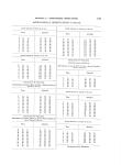
INDEX. Thoirne's wells.......................n......... 30 Timber Between 32d and 34th parallels................- 5 32d parallel, near Guadalutpe mountains........ 7, 8 Valley of the Pecos.................... ----— 8,29 Valley of Red river.......................... 9, 24, 25 Valley of the Brazos.**....* —........9, 26-27, 40, 88 Country drained by tributaries of Red river.... 10 Between Arkansas and Rio Grande valley...... 10 33d parallel................................ 22 Colorado valley............................. 22,27,28 East face of Guadalupe mountains -....-........ 11,44 West face of Guadalupe mountains............. 11 Trinity River valley.... —..... —.. —...... 26 Llano Estacado... -..... —---------------------......28,41-42 Between Red river and base of Llano Estacado. 40-41 Between Pecos river and Rio Grande.......... 42-45 (See Wood.) Tonkawa Indians................................ 17 Trinity river and valley.................... 26 Tephrosia...................................... 162 Teucrium..................................... 169 Thelesperma................................... 167 Tiquilia............................. 171 Tornio......................................... 163 Townsendia.................................... 166 Tradescantia................................... 176 Tragia......................................... 174 Tripsacu a..................................... 176 Scirpus........................................ Screw-bean*-........e.......o*._...u...._....*.T eScrew-tree..................................... Scrophulariace,e................................ Scutellaria..................................... Selenia........................................ Senecio......... Sieydium.................................... Silene...e.-.*.........*.*.*.*............ Simsia......................................... Sisymbrium.................................... Sisyrinchium................................... Smilaceve....................................... Smilax........................................ Solanacese..................................... Solanum....................................... Solidago....................................... Sophora....................................... Sphaeralcea.................................... Stegnocarpus................................... Stenandriuml..................... Stellingia........* **......................n.... S t r e p t a n t h u s --—.......e —--------------------- Strombocarpa —.....-................ —-------- Stylosanthes.,................................... Sueda......................................... T abl es Cost, length, &c., of road.................... Ascents and descents............. Upper Cross Timbers...............-...... 926, Utah Indians-................................... Umbellifer-...................................., Ungnadia....-......................... Urticacee3..................................... Analyses of soils........................... 95, 96, 97 Analyses of mineral waters..................- 97 Camping places on line of survey.............. 98-99 Meteorological observation s.................. 100-103 Latitude, longitude, and magnetic declinations.. 104 Altitude of stations above sea-level............ 105-107 Observations for determining profile from E1 Paso to Preston........................... 108-110 Observations for determining profile from Emi grant Crossing of the Pecos to Big Springs of Colorado................ V........... 1 Observations for determining profile through San Augustine Pass of the Organ mountains. ----—... 111 Astronomical observations................... 112-156 Tanks Alamos.................................... Cornudos, or Thorne's wells..................ae Hueco..................................... (See Springs.) Taplin, Captain C. L. Charge of geological collection............... Detail of....-.-. —------------------------- Instructions to for examining the Llano Estacado Report.................................... Terminus (eastern) of the road................... Texas Grant of land by............................ Settlement of........n....-.e.............e. Waco Indians.................................. 17 Water Between 32d and 34th parallels........ —------------- 5 Between valley of Rio Grande and Red river.. 6 Between valley of Rio Grande and Pecos river. 6, 42-45 Between Arkansas and Rio Grande valley...... 10 Along the route -.........11-12, 21, 98-99 In Llano Estacado............... 11,21,28-29,35-38 Route from La Vaca bay to Dona Ana.........23 Valley of Delaware creek.................... 23,29-30 Jornada del Muerto.. ——.. —---—.... —----------—. 24 Between Red river and Llano Estacado........ 40-41 I I 184 P age. 176 163 163 1.68 169 160,177 167 164 160 166 159 176 176 176 172 172 166 163 161 169,178 168, 177 174 159 163 163 173 Page. 30 i I T. 45 46 U. Nat-Liral history collection.................... 94 40, 90 17 1 165 162 175 V. Valerianacece.................................... Verbena....................................... Verbenace.T.................................... Veronica...................................... Vesicaria...................................... Vicia.......................................... Vitacem....................................... Vitia........................................... 166 169 169 168 159,160 162 162 162 W. 11, 30 31, 30 7,11, 30 3 52 60 73 49 . 50 48
-
Scan 1

Page R001 - Title Page
-
Scan 2

Page R002
-
Scan 3

Page R003
-
Scan 4

Page R004
-
Scan 5

Page R005
-
Scan 6

Page R006
-
Scan 7

Page 1
-
Scan 8

Page 2
-
Scan 9

Page 3
-
Scan 10

Page 4
-
Scan 11

Page 5
-
Scan 12

Page 6
-
Scan 13

Page 7
-
Scan 14

Page 8
-
Scan 15

Page 9
-
Scan 16

Page 10
-
Scan 17

Page 11
-
Scan 18

Page 12
-
Scan 19
Page 13
-
Scan 20

Page 14
-
Scan 21

Page 15
-
Scan 22

Page 16
-
Scan 23

Page 17
-
Scan 24

Page 18
-
Scan 25

Page 19
-
Scan 26

Page 20
-
Scan 27

Page 21
-
Scan 28

Page 22
-
Scan 29

Page 23
-
Scan 30

Page 24
-
Scan 31

Page 25
-
Scan 32

Page 26
-
Scan 33

Page 27
-
Scan 34

Page 28
-
Scan 35

Page 29
-
Scan 36

Page 30
-
Scan 37

Page 31
-
Scan 38
Page 32
-
Scan 39

Page 33
-
Scan 40

Page 34
-
Scan 41

Page 35
-
Scan 42

Page 36
-
Scan 43

Page 37
-
Scan 44

Page 38
-
Scan 45

Page 39
-
Scan 46

Page 40
-
Scan 47

Page 41
-
Scan 48

Page 42
-
Scan 49

Page 43
-
Scan 50

Page 44
-
Scan 51

Page 45
-
Scan 52

Page 46
-
Scan 53

Page 47
-
Scan 54

Page 48
-
Scan 55

Page 49
-
Scan 56

Page 50
-
Scan 57

Page 51
-
Scan 58

Page 52
-
Scan 59

Page 53
-
Scan 60

Page 54
-
Scan 61

Page 55
-
Scan 62

Page 56
-
Scan 63
Page 57
-
Scan 64

Page 58
-
Scan 65

Page 59
-
Scan 66

Page 60
-
Scan 67

Page 61
-
Scan 68

Page 62
-
Scan 69

Page 63
-
Scan 70

Page 64
-
Scan 71

Page 65
-
Scan 72

Page 66
-
Scan 73

Page 67
-
Scan 74

Page 68
-
Scan 75

Page 69
-
Scan 76

Page 70
-
Scan 77

Page 71
-
Scan 78

Page 72
-
Scan 79

Page 73
-
Scan 80

Page 74
-
Scan 81

Page 75
-
Scan 82

Page 76
-
Scan 83

Page 77
-
Scan 84

Page 78
-
Scan 85

Page 79
-
Scan 86

Page 80
-
Scan 87

Page 81
-
Scan 88

Page 82
-
Scan 89

Page 83
-
Scan 90

Page 84
-
Scan 91

Page 85
-
Scan 92

Page 86
-
Scan 93

Page 87
-
Scan 94

Page 88
-
Scan 95

Page 89
-
Scan 96

Page 90
-
Scan 97

Page 91
-
Scan 98

Page 92
-
Scan 99

Page 93
-
Scan 100

Page 94
-
Scan 101

Page 95
-
Scan 102

Page 96
-
Scan 103

Page 97
-
Scan 104

Page 98
-
Scan 105

Page 99
-
Scan 106

Page 100
-
Scan 107

Page 101
-
Scan 108

Page 102
-
Scan 109

Page 103
-
Scan 110

Page 104
-
Scan 111

Page 105
-
Scan 112

Page 106
-
Scan 113

Page 107
-
Scan 114

Page 108
-
Scan 115

Page 109
-
Scan 116

Page 110
-
Scan 117

Page 111
-
Scan 118

Page 112
-
Scan 119

Page 113
-
Scan 120

Page 114
-
Scan 121

Page 115
-
Scan 122

Page 116
-
Scan 123

Page 117
-
Scan 124

Page 118
-
Scan 125

Page 119
-
Scan 126

Page 120
-
Scan 127

Page 121
-
Scan 128

Page 122
-
Scan 129
Page 123
-
Scan 130

Page 124
-
Scan 131

Page 125
-
Scan 132

Page 126
-
Scan 133

Page 127
-
Scan 134

Page 128
-
Scan 135

Page 129
-
Scan 136
Page 130
-
Scan 137

Page 131
-
Scan 138

Page 132
-
Scan 139

Page 133
-
Scan 140

Page 134
-
Scan 141

Page 135
-
Scan 142

Page 136
-
Scan 143

Page 137
-
Scan 144

Page 138
-
Scan 145

Page 139
-
Scan 146

Page 140
-
Scan 147

Page 141
-
Scan 148

Page 142
-
Scan 149

Page 143
-
Scan 150

Page 144
-
Scan 151

Page 145
-
Scan 152

Page 146
-
Scan 153

Page 147
-
Scan 154

Page 148
-
Scan 155

Page 149
-
Scan 156

Page 150
-
Scan 157

Page 151
-
Scan 158

Page 152
-
Scan 159

Page 153
-
Scan 160

Page 154
-
Scan 161

Page 155
-
Scan 162

Page 156
-
Scan 163

Page 157
-
Scan 164

Page 158
-
Scan 165

Page 159
-
Scan 166

Page 160
-
Scan 167

Page R001
-
Scan 168

Page R01A
-
Scan 169

Page 161
-
Scan 170

Page 162
-
Scan 171

Page 163
-
Scan 172

Page 164
-
Scan 173

Page 165
-
Scan 174

Page 166
-
Scan 175

Page R002
-
Scan 176

Page R02A
-
Scan 177

Page R003 - Table of Contents
-
Scan 178

Page R03A - Table of Contents
-
Scan 179

Page 167 - Table of Contents
-
Scan 180

Page 168 - Table of Contents
-
Scan 181

Page R004 - Table of Contents
-
Scan 182

Page R04A
-
Scan 183

Page R005
-
Scan 184

Page R05A
-
Scan 185

Page R006
-
Scan 186

Page R06A
-
Scan 187

Page R007
-
Scan 188

Page R07A
-
Scan 189

Page 169
-
Scan 190

Page 170
-
Scan 191

Page R008
-
Scan 192

Page R08A
-
Scan 193

Page R009
-
Scan 194

Page R09A
-
Scan 195
Page 171
-
Scan 196

Page 172
-
Scan 197

Page R010
-
Scan 198

Page R10A
-
Scan 199

Page 173
-
Scan 200

Page 174
-
Scan 201

Page 175
-
Scan 202

Page 176
-
Scan 203

Page 177
-
Scan 204

Page 178
-
Scan 205

Page 179 - Comprehensive Index
-
Scan 206

Page 180 - Comprehensive Index
-
Scan 207

Page 181 - Comprehensive Index
-
Scan 208

Page 182 - Comprehensive Index
-
Scan 209

Page 183 - Comprehensive Index
-
Scan 210

Page 184 - Comprehensive Index
-
Scan 211

Page 185 - Comprehensive Index
-
Scan 212

Page 186
-
Scan 213

Page 187
-
Scan 214

Page 188
About this Item
- Title
- Reports of explorations and surveys, to ascertain the most practicable and economical route for a railroad from the Mississippi River to the Pacific Ocean: Vol. 2, Pt. 4
- Author
- United States. War Dept.
- Canvas
- Page 184 - Comprehensive Index
- Publication
- Washington,: A. O. P. Nicholson, printer [etc.]
- 1855
- Subject terms
- Pacific railroads -- Explorations and surveys.
- Natural history -- West (U.S.)
- Indians of North America -- West (U.S.)
- West (U.S.) -- Description and travel.
- United States -- Exploring expeditions.
Technical Details
- Collection
- Making of America Books
- Link to this Item
-
https://name.umdl.umich.edu/afk4383.0002.004
- Link to this scan
-
https://quod.lib.umich.edu/m/moa/afk4383.0002.004/210
Rights and Permissions
These pages may be freely searched and displayed. Permission must be received for subsequent distribution in print or electronically. Please go to http://www.umdl.umich.edu/ for more information.
Related Links
IIIF
- Manifest
-
https://quod.lib.umich.edu/cgi/t/text/api/manifest/moa:afk4383.0002.004
Cite this Item
- Full citation
-
"Reports of explorations and surveys, to ascertain the most practicable and economical route for a railroad from the Mississippi River to the Pacific Ocean: Vol. 2, Pt. 4." In the digital collection Making of America Books. https://name.umdl.umich.edu/afk4383.0002.004. University of Michigan Library Digital Collections. Accessed June 15, 2025.