Reports of explorations and surveys, to ascertain the most practicable and economical route for a railroad from the Mississippi River to the Pacific Ocean: Vol. 2, Pt. 4
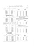
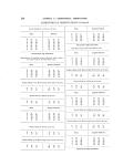
APPENDIX L.-ASTRONOMICAL OBSERVATIONS. ASTRONOMICAL OBSERVATIONS-Continued. Determnzination of longitude by lunar distances.-The Moon's west erny limb and Pollux, west. Altitude. Magnetic bearing. d. m. s. d. mn. s. 74 59 30 S. 49 00 00 E. Time. A. m. s. 7 00 31 7 O3 19 7 05 18 7 07 03 Variation of compass, E. 100 19' 12". Thermometer 66~ Fah. Double altitude of the Moon's upper limb, in the east. Time. Altitude. h. m. s. d. m. s. 7 08 49 69 20 55 DETERMINATION OF LONGITUDE nBY LUNAR DISTANCES. Approximate latitude to be used in first computation of time, 33~ 45'. Determination of time, May 10, 1854.-Double altitudes of Pol lux, in the west. Time. Altitudes. Chronometer slow o mean time. h. m. M. d s.h. m.s. 6 38 24 94 44 25 1 3 15.4 6 39 33 94 1705 1 3 12.3 6 40 22 93 56 55 1 3 12.4 6 41 18 93 34 15 1 3 16.5 6 42 13 93 10 05 1 3 14.5 6 43 05 92 48 25 1 3 13.5 6 43 57 92 27 45 ] 3 12.0 6 44 55 92 03 05 1 3 13.8 6 45 40 91 44 15 1 3 13.0 6 46 33 91 22 55 Double altitudes of Areturus, in the east. Time. Altitudes. Chronometer slow of mean time. h. m. s. d.. s. h. m. s. 6 48 23 94 32 45 1 3 14. 3 6 49 22 94 57 05 1 3 13.8 6 50 27 95 25 55 1 3 16.4 6 51 13 95 4305 1 3 14.6 6 51 57 96 01 05 1 3 13.8 6 52 53 96 24 35 1 3 14.6 6 53 47 96 47 35 1 3 16.4 6 54 34 97 0605 1 3 14. 4 6 55 17 97 24 25 1 3 15.6 6 56 13 97 4705 1 3 14.6 Time. Altitude. h. m. s. d. M. s. 7 11 30 81 08 15 h. M59. 7 13 7 15 7 16 7 18 7 18 59 98 15 OS 6 29 OS Time. Altitude. h. m. s. d. Mn. s. 7 23 38 73 27 35 Thermometer 56~ Fahrenheit. I 154 Double altitude of qpica Vi?-,,,inis, in the cast. Tiine. A. M. S. 7 21 03 Deduced longitude. h. M..3. Angular distaneeig. d. m. s. 98 06 15 98 07 35 8 ('8 3 I'j 98 09 25 6 29 07 ON ELM FORK OF TRINITY RIVER. Double altitude of Pollux, in the we-st. Time. Angular.distances. Ded,uced loi3gitude. h. M. S. c7,. 98 98 98 98 S. 17 00 55 59 M. I I l 14 15 S. 45 55 05 05 6 29 08 .Double altitude of Pollux, in the west. Time. Altitude. h. M. S. d. M. S. 7 22 07 76 46 55 Double altitude of the JI-oon's upper linib, in the east.
-
Scan 1

Page R001 - Title Page
-
Scan 2

Page R002
-
Scan 3

Page R003
-
Scan 4

Page R004
-
Scan 5

Page R005
-
Scan 6

Page R006
-
Scan 7

Page 1
-
Scan 8

Page 2
-
Scan 9

Page 3
-
Scan 10

Page 4
-
Scan 11

Page 5
-
Scan 12

Page 6
-
Scan 13

Page 7
-
Scan 14

Page 8
-
Scan 15

Page 9
-
Scan 16

Page 10
-
Scan 17

Page 11
-
Scan 18

Page 12
-
Scan 19
Page 13
-
Scan 20

Page 14
-
Scan 21

Page 15
-
Scan 22

Page 16
-
Scan 23

Page 17
-
Scan 24

Page 18
-
Scan 25

Page 19
-
Scan 26

Page 20
-
Scan 27

Page 21
-
Scan 28

Page 22
-
Scan 29

Page 23
-
Scan 30

Page 24
-
Scan 31

Page 25
-
Scan 32

Page 26
-
Scan 33

Page 27
-
Scan 34

Page 28
-
Scan 35

Page 29
-
Scan 36

Page 30
-
Scan 37

Page 31
-
Scan 38
Page 32
-
Scan 39

Page 33
-
Scan 40

Page 34
-
Scan 41

Page 35
-
Scan 42

Page 36
-
Scan 43

Page 37
-
Scan 44

Page 38
-
Scan 45

Page 39
-
Scan 46

Page 40
-
Scan 47

Page 41
-
Scan 48

Page 42
-
Scan 49

Page 43
-
Scan 50

Page 44
-
Scan 51

Page 45
-
Scan 52

Page 46
-
Scan 53

Page 47
-
Scan 54

Page 48
-
Scan 55

Page 49
-
Scan 56

Page 50
-
Scan 57

Page 51
-
Scan 58

Page 52
-
Scan 59

Page 53
-
Scan 60

Page 54
-
Scan 61

Page 55
-
Scan 62

Page 56
-
Scan 63
Page 57
-
Scan 64

Page 58
-
Scan 65

Page 59
-
Scan 66

Page 60
-
Scan 67

Page 61
-
Scan 68

Page 62
-
Scan 69

Page 63
-
Scan 70

Page 64
-
Scan 71

Page 65
-
Scan 72

Page 66
-
Scan 73

Page 67
-
Scan 74

Page 68
-
Scan 75

Page 69
-
Scan 76

Page 70
-
Scan 77

Page 71
-
Scan 78

Page 72
-
Scan 79

Page 73
-
Scan 80

Page 74
-
Scan 81

Page 75
-
Scan 82

Page 76
-
Scan 83

Page 77
-
Scan 84

Page 78
-
Scan 85

Page 79
-
Scan 86

Page 80
-
Scan 87

Page 81
-
Scan 88

Page 82
-
Scan 89

Page 83
-
Scan 90

Page 84
-
Scan 91

Page 85
-
Scan 92

Page 86
-
Scan 93

Page 87
-
Scan 94

Page 88
-
Scan 95

Page 89
-
Scan 96

Page 90
-
Scan 97

Page 91
-
Scan 98

Page 92
-
Scan 99

Page 93
-
Scan 100

Page 94
-
Scan 101

Page 95
-
Scan 102

Page 96
-
Scan 103

Page 97
-
Scan 104

Page 98
-
Scan 105

Page 99
-
Scan 106

Page 100
-
Scan 107

Page 101
-
Scan 108

Page 102
-
Scan 109

Page 103
-
Scan 110

Page 104
-
Scan 111

Page 105
-
Scan 112

Page 106
-
Scan 113

Page 107
-
Scan 114

Page 108
-
Scan 115

Page 109
-
Scan 116

Page 110
-
Scan 117

Page 111
-
Scan 118

Page 112
-
Scan 119

Page 113
-
Scan 120

Page 114
-
Scan 121

Page 115
-
Scan 122

Page 116
-
Scan 123

Page 117
-
Scan 124

Page 118
-
Scan 125

Page 119
-
Scan 126

Page 120
-
Scan 127

Page 121
-
Scan 128

Page 122
-
Scan 129
Page 123
-
Scan 130

Page 124
-
Scan 131

Page 125
-
Scan 132

Page 126
-
Scan 133

Page 127
-
Scan 134

Page 128
-
Scan 135

Page 129
-
Scan 136
Page 130
-
Scan 137

Page 131
-
Scan 138

Page 132
-
Scan 139

Page 133
-
Scan 140

Page 134
-
Scan 141

Page 135
-
Scan 142

Page 136
-
Scan 143

Page 137
-
Scan 144

Page 138
-
Scan 145

Page 139
-
Scan 146

Page 140
-
Scan 147

Page 141
-
Scan 148

Page 142
-
Scan 149

Page 143
-
Scan 150

Page 144
-
Scan 151

Page 145
-
Scan 152

Page 146
-
Scan 153

Page 147
-
Scan 154

Page 148
-
Scan 155

Page 149
-
Scan 156

Page 150
-
Scan 157

Page 151
-
Scan 158

Page 152
-
Scan 159

Page 153
-
Scan 160

Page 154
-
Scan 161

Page 155
-
Scan 162

Page 156
-
Scan 163

Page 157
-
Scan 164

Page 158
-
Scan 165

Page 159
-
Scan 166

Page 160
-
Scan 167

Page R001
-
Scan 168

Page R01A
-
Scan 169

Page 161
-
Scan 170

Page 162
-
Scan 171

Page 163
-
Scan 172

Page 164
-
Scan 173

Page 165
-
Scan 174

Page 166
-
Scan 175

Page R002
-
Scan 176

Page R02A
-
Scan 177

Page R003 - Table of Contents
-
Scan 178

Page R03A - Table of Contents
-
Scan 179

Page 167 - Table of Contents
-
Scan 180

Page 168 - Table of Contents
-
Scan 181

Page R004 - Table of Contents
-
Scan 182

Page R04A
-
Scan 183

Page R005
-
Scan 184

Page R05A
-
Scan 185

Page R006
-
Scan 186

Page R06A
-
Scan 187

Page R007
-
Scan 188

Page R07A
-
Scan 189

Page 169
-
Scan 190

Page 170
-
Scan 191

Page R008
-
Scan 192

Page R08A
-
Scan 193

Page R009
-
Scan 194

Page R09A
-
Scan 195
Page 171
-
Scan 196

Page 172
-
Scan 197

Page R010
-
Scan 198

Page R10A
-
Scan 199

Page 173
-
Scan 200

Page 174
-
Scan 201

Page 175
-
Scan 202

Page 176
-
Scan 203

Page 177
-
Scan 204

Page 178
-
Scan 205

Page 179 - Comprehensive Index
-
Scan 206

Page 180 - Comprehensive Index
-
Scan 207

Page 181 - Comprehensive Index
-
Scan 208

Page 182 - Comprehensive Index
-
Scan 209

Page 183 - Comprehensive Index
-
Scan 210

Page 184 - Comprehensive Index
-
Scan 211

Page 185 - Comprehensive Index
-
Scan 212

Page 186
-
Scan 213

Page 187
-
Scan 214

Page 188
About this Item
- Title
- Reports of explorations and surveys, to ascertain the most practicable and economical route for a railroad from the Mississippi River to the Pacific Ocean: Vol. 2, Pt. 4
- Author
- United States. War Dept.
- Canvas
- Page 154
- Publication
- Washington,: A. O. P. Nicholson, printer [etc.]
- 1855
- Subject terms
- Pacific railroads -- Explorations and surveys.
- Natural history -- West (U.S.)
- Indians of North America -- West (U.S.)
- West (U.S.) -- Description and travel.
- United States -- Exploring expeditions.
Technical Details
- Collection
- Making of America Books
- Link to this Item
-
https://name.umdl.umich.edu/afk4383.0002.004
- Link to this scan
-
https://quod.lib.umich.edu/m/moa/afk4383.0002.004/160
Rights and Permissions
These pages may be freely searched and displayed. Permission must be received for subsequent distribution in print or electronically. Please go to http://www.umdl.umich.edu/ for more information.
Related Links
IIIF
- Manifest
-
https://quod.lib.umich.edu/cgi/t/text/api/manifest/moa:afk4383.0002.004
Cite this Item
- Full citation
-
"Reports of explorations and surveys, to ascertain the most practicable and economical route for a railroad from the Mississippi River to the Pacific Ocean: Vol. 2, Pt. 4." In the digital collection Making of America Books. https://name.umdl.umich.edu/afk4383.0002.004. University of Michigan Library Digital Collections. Accessed June 20, 2025.