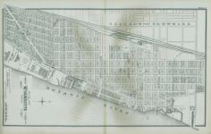
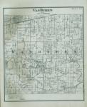
Detailed official atlas of Wayne County, Michigan : containing general maps of Wayne County and city of Detroit, general township maps...and detail plats of the city of Wyandotte and all interior villages...also sundry details showing all subdivisions outside the incorporated villages and an alphabetically arranged index for reference to locating subdivisions / compiled and drawn from authentic records and private surveys by W. C. Sauer.
..-!~~~~~A 7' -ý -4T. *;g~y '* r -.
-
Scan 1

Page #1
-
Scan 2

Page #2 - Front Matter
-
Scan 3

Page #3 - Front Matter
-
Scan 4

Page #4 - Front Matter
-
Scan 5

Page #5 - Title Page
-
Scan 6

Page #6
-
Scan 7

Page #7 - Comprehensive Index
-
Scan 8

Page 1
-
Scan 9

Page 2
-
Scan 10

Page 3
-
Scan 11

Page 4
-
Scan 12

Page 5
-
Scan 13

Page 6
-
Scan 14

Page 7
-
Scan 15

Page 8
-
Scan 16

Page 9
-
Scan 17

Page 10
-
Scan 18
Page 11
-
Scan 19

Page 12
-
Scan 20

Page 13
-
Scan 21

Page 14
-
Scan 22

Page 15
-
Scan 23

Page 16
-
Scan 24

Page 17
-
Scan 25

Page 18
-
Scan 26

Page 19
-
Scan 27

Page 20
-
Scan 28

Page 21
-
Scan 29
Page 22
-
Scan 30

Page 23
-
Scan 31

Page 24
-
Scan 32

Page 25
-
Scan 33

Page 26
-
Scan 34

Page 27
-
Scan 35

Page 28
-
Scan 36

Page 29
-
Scan 37

Page 30
-
Scan 38

Page 31
-
Scan 39

Page 32
-
Scan 40

Page 33
-
Scan 41

Page 34
-
Scan 42

Page 35
-
Scan 43

Page 36
-
Scan 44

Page 37
-
Scan 45

Page 38
-
Scan 46

Page 39
-
Scan 47

Page 40
-
Scan 48

Page 41
-
Scan 49

Page 42
-
Scan 50

Page 43
-
Scan 51

Page 44
-
Scan 52

Page 45
-
Scan 53

Page 46
-
Scan 54

Page 47
-
Scan 55

Page 48
-
Scan 56

Page 49
-
Scan 57

Page 50
-
Scan 58

Page 51
-
Scan 59

Page 52
-
Scan 60

Page 53
-
Scan 61

Page 54
-
Scan 62

Page 55
-
Scan 63

Page 56
-
Scan 64

Page 57
-
Scan 65

Page 58
-
Scan 66

Page 59
-
Scan 67

Page 60
-
Scan 68

Page 61
-
Scan 69

Page 62
-
Scan 70

Page 63
-
Scan 71

Page 64
-
Scan 72

Page 65
About this Item
- Title
- Detailed official atlas of Wayne County, Michigan : containing general maps of Wayne County and city of Detroit, general township maps...and detail plats of the city of Wyandotte and all interior villages...also sundry details showing all subdivisions outside the incorporated villages and an alphabetically arranged index for reference to locating subdivisions / compiled and drawn from authentic records and private surveys by W. C. Sauer.
- Author
- Sauer, Wm. C.
- Canvas
- Page #1
- Publication
- [Detroit, Mich. :: W. C. Sauer,
- 1904]
- Subject terms
- Real property -- Maps. -- Michigan
- Landowners -- Maps. -- Michigan
- Wayne County (Mich.) -- Maps.
- Atlases.
Technical Details
- Collection
- Michigan County Histories and Atlases
- Link to this Item
-
https://name.umdl.umich.edu/3928153.0001.001
- Link to this scan
-
https://quod.lib.umich.edu/m/micounty/3928153.0001.001/1
Rights and Permissions
The University of Michigan Library provides access to these materials for educational and research purposes. These materials are believed to be in the public domain in the United States; however, if you decide to use any of these materials, you are responsible for making your own legal assessment and securing any necessary permission.
DPLA Rights Statement: No Copyright - United States
Related Links
IIIF
- Manifest
-
https://quod.lib.umich.edu/cgi/t/text/api/manifest/micounty:3928153.0001.001
Cite this Item
- Full citation
-
"Detailed official atlas of Wayne County, Michigan : containing general maps of Wayne County and city of Detroit, general township maps...and detail plats of the city of Wyandotte and all interior villages...also sundry details showing all subdivisions outside the incorporated villages and an alphabetically arranged index for reference to locating subdivisions / compiled and drawn from authentic records and private surveys by W. C. Sauer." In the digital collection Michigan County Histories and Atlases. https://name.umdl.umich.edu/3928153.0001.001. University of Michigan Library Digital Collections. Accessed May 3, 2025.