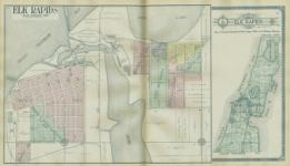
Standard atlas of Antrim County, Michigan : including a plat book of the villages, cities and townships of the county...patrons directory, reference business directory and departments devoted to general information / compiled and published by Geo. A. Ogle & Co.
SUPPLEMENT II. UNITED STATES LAND SURVEYS These lines are termed " Range Lines." They divide the land into strips or divisions six miles wide, extending North and South, parallel with the Meridian. Each division is called a Range. Ranges are numbered from one upward, comm, cing at the Meridian; and their numbers are indicated by Roman characters. For instance, the first division (or first six miles) west of the Meridian i0 Range I. West; the next is Range II. West; then comes Range III., IV., V., VI., VII., and so on, until the territory governed by another Principal Meridian is reached. In the same manner the Ranges East of the Meridian are numbered, the words East or West being always used to indicate the direction from the Principal Meridian. See Diagram 3. Commencing at the Base Line, at intervals of six miles, lines are run East and West parallel with the Base L —e. These are designated as Township Lines. They divide the land into strips or divisions six miles wide, extending East and West, parallel with the Base Line. This plan is followed both North and South of the Base Line until the territory goverhed by another Principal Meridian and Base Line is reached. These divisions or Townships are numbered from one upward, both North and South of the Base Line, and their numbers are indicated by figures. For instance: The first six mile division n-orth of the Base Line is Township 1 North; the next is Township 2 North; then comes Township 3, 4, 5, and 6, North, and so on. The same plan is followed South of the Base Line; the Townships being designated as Township 1 South, Townshii 2 South, and so on. The f' North " or "South " (the initials N. or S. being generally used) indicates the direction from the Base Line. See Diagram 3. These Township and Range Lines, crossing each other, as showns in Diagram. 3, form squares, whisch are called "Townships" or " Government Townships," which are six miles square, or as nearly that as it is possible to make them. These Townships are a very important feature in locating or describing a piece of laud. The location of a Government Township, however, is very readily found when the number of the Township and Range is given, by merely counting the number indicated from the Base Line and Principal Meridian. As an example of this, Township 8 North, Range 4, West or tile 5thl Principal Meridian, is at once located on the square marked * on Diagram 3, by counting eight tiers north of the Base Line and 4 tiers west of the Meridian. I)ILORBM[ 9 UOPZO~TIIPY d MaCTOI~2llr-~L r rr rrr n III n m rr v u 4 4 IP 4 X c I~ a I T rlTI I I I r I a DI I I I I I at I I L i h o 4 I I I I I I -~ I i I I J a L L I 1 I I I I I I I I~ L I I r I I i — ~ I r -r I. L 4 11 I I I I I I 1 I II o 4 a TOWNSHIPS OF LAND. OWNSHIPS are the largest sub) divisions of land run out by the I United States Surveyors. In the Governmental Surveys Township Lines are the first to be run, and a Township Corner is established every six miles and marked. This is called "Townshipping." After the Township Corners have been carefully located,the Section and Quarter Section Corners are established. Each Township is six miles square and contains 23,040 acres, or -36 square miles, as near as it is possible to make them. This, however, is frequently made impossible by; (1st) the presence of lakes and large streams; A2nd) by State boundaries not falling exactly on Township Lines; (3rd) by the convergence of Meridians or curvature of the earth's surface; and (4th) by inaccurate surveys. Each Township, unless it is one of the exceptional cases referred to, is divided into 36 squares, which are called Sections. These Sections are intended to be one mile, or 320 rods, square and contain 640 acres of land. Sections are numbered consecutively from 1 to 36, as shown on Diagram 4. Beginning with Section 1 in the Northeast Corner, they run West to 6, then East to 12, then West to 18, and so on, back and forth, until they end with Section 36 in the Southeast Corner. Diagram 4 shows a plat of a Township as it is divided and platted by the government surveyors. These Townships are called Government Townships or Congressional Townships, to distinguish them from Civil Townships o organized Townships, as frequently the lines of organized Townships do not conform to the Government Township lines. _ _ DL&GR WI i, d of c- 1111 aa 8o!a II1 la I.; I, -T.; L r i 6 4 62 R. LOZ R so R. A. R 08 R. I.9.2 R 22.6s R. I3 263. R. i 129.. R. I 1. - 1 SECTIONS OF LAND. --- -.1 32 - 555|5.332. 3 3 TAGRAM 5 illustrates how a section may be subdivided, although the.s — Diagram only gives a few of the in.. ____ many subdivisions into which a, - section may be divi-ed. All Sections (except fractional Sections) are supposed to be 320 rods, or one mile, square and therefore contain 640 acres-a number easily divisible. Sections are subdivided into fractional parts to suit the convenience of the owners of the land. A half-section contains 320 acres; a quarter-section contains 160 acres; half of a quarter contains 80 acres, and quarter of a quarter contains 40 acres, and so on. Each piece of land is described according to the portion of the section which it embraces-as the Northeast quarter of Section 10; or the Southeast quarter of the Southeast quarter of Section 10. Diagram 5 shows how many of these subdivisions are-platted, and also shows the plan of designating and describing them by initial letters as each parcel of land on the Diagram is marked with its description. As has already been stated, all Sections (except Fractional Sections which are explained elsewhere) are supposed to contain 640 acres, and even though mistakes have been made in surveying, as is frequently the case, making sections larger or smaller than 640 acres, the Government recognizes no variation, but sells or grants each regular section as containing 640 acres "more or less." The Government Surveyors are not required to subdivide sections by running lines within them, but they usually establish Quarter Posts on Section Lines on each side of a section at the noints marked A. B. C. and D. on Diagram 5. After establishing Township corners, Section __Lines are the next to be run, and section corners are established. When these are carefully DIAGRAM 5. located the Quarter Posts are located at points as nearly equidistant between Section Corners as i possible. These corners when established by Government Surveyors cannot be changed, even though it is conclusively slhown that mistakes have been made lwhich cause some sections or 9 N. E 1/* quarter sections to be either larger or smaller.. than others. The laws, however, of all the Q States provide certain rules for local surveyors < to follow in dividing Sections into smaller 160 A. parcels of land than has been outlined in the A C 10. Governmental surveys. For instance, in divide0 c ing a quarter section into two parcels, the disfully measured and the new post is located at a 80 A. point equidistant between them. This plan is. N. WofS. followed in running out "eighties," "'forties," of SE.iE. 4 E- "twenties," etc. In this way, if the Govern2 0A.1 of S. E.-/' ment division overruns or falls short, each S f portion gains or loses its proportion. This is.si. (20A.) 40 A. not the case, however, with Fractional Sections SUBDIVIDING A SECTION. along the North or West sides of a Township, or adjoining a lake or large stream. I 4 I F. B ABB I- - -W -A M d, - - - - - -l L: - t~ 12 FRACTIONAL PIECES OF LAND. ( ONGRESSIONAL Townships vary considerably as to size and boundaries. Mistakes made in surveying and the fact that Meridians converge as they run North cause every Township to vary 16 14 18 more or less from the 23,040 acres which a perfect Township would contain. See Diagran 4. In arranging a Township into Sections all the surplus or deficiency of land 1_ 1 is given to, or taken from, the North and West tiers of Sections. In other words, all l Sections in the Township are made fullt 640 acres-except those on the North and 22 23 1e ~ 24 Vest, which are given all the land that is It- lL * 4 left after forming the other 25 Sections. I - 5*fTTM Diagram 4 illustrates how the surplus or _ tt -deficiency is distributed and the Sections it.e olects. It will be seen that Sections 1, 2, 3, 4, 5, 6, 7, 18, 19, 30 and 31, are the " Fractional Sections," or the Sections which are affected if the Township overruns 27 26 26 8 or falls short. Inside of these Fractional Sections, all of the surplus or deficiency of land (over or under 640 acres) is carried to the "forties" or "eighties" that touch the L -' Township Line. These pieces of land are --- called "Fractional Forties" or "Fractional - Eighties," as the case may be. Diagrams 4 and 6 show the manner of marking the 34 acreage and outlining the boundaries of these "Fractions." Diagram 6 illustrates how the surplus or deficiency of land inside of these Sections is distributed and which "for ies"or "eighties" it affects. From this arrangement it willbe seen that in any Section that touches the North or West Township Lines, the Southeast Quarter may be full-160 acres-while another quarter of the same Section may be much larger or smalir. Frequently these fractional "forties" or "eighties" are lotted as shown in Diagram 6. They are always described as fractional tracts of land, as the "fractional S.W. * of Section 6,"etc. Of courser those portions of these Sections which are not affected by these variations are described in the usual manner-as Southeast j of Section 6. As a rule Townships are narrower at the North than at the South side. The Meridians of Longitude (which run North and South) cbnvergeas they run North and South from the Equator. They begin at the Equator with a definite width between them and graduallyconvergeuntiltheyall meet atthepoles. Now, as the Range liilesarerun North andSouth, it will at once be seen that the convergence of Meridians will caue^ every Congressional Township (North of the Equator) to be narrower at its North than at its South side, as stated. See Diagram 4. In addition to this fact, mistakes of measurement are constantly and almost unavoidably made in runningboth Township and Range lines, and if no new starting points were established the lines would DI AGRAM 6. become confused and unreliable, and 1 B' the size and shape of Townships 4. LOT 3. OT?. LOT 1. materially affected by the time the surveys had extended even a hundred ' l 8o l 83 ai 80.5 miles from the Base Line and Princi- 62 AC. ACRES. ACRES ACRES. pal iMeridian. In order to correct the surveys and variations caused 53 R. by the difference of latitude and LOT. straighten the lines, "Correction. Lines" (or Guide NMeridians and 20 C ~ A 80 ACRES.4 Standard Parallels) are established at ACRES. frequent intervals, usually as followss: North of the Base Line a Correction 58. I S R. Line is run East and West parallel LOT 6. 160 Rods with the Base Line, usually every A twentv-four miles. South of the |32 AC. C Base Line a Correction Line is usually 'E established every thirty miles. Both 64 BR. - ) 160 ACRES. East and West of the Principal LOT 7-. < Meridian "Correction Lines" are 0 usually established every 48 miles. | 37 AC. a0 All Correction Lines are located by careful measurement, and the suc- I 74 R 80 Rods 160 Rods. ceeding surveys are based upon PLAT OP A FRACTIONAL SECTIOIN. them. I * Entered According to Act of Congress, in the year 1909, by Geo. A. Ogle & Co., in the office of the Librarian of Congress at Washington, D. C. J
-
Scan 1

Page #1 - Front Matter
-
Scan 2

Page #2 - Front Matter
-
Scan 3

Page 1
-
Scan 4

Page 2
-
Scan 5

Page 3 - Title Page
-
Scan 6

Page 4
-
Scan 7

Page 5 - Table of Contents
-
Scan 8

Page 6 - List of Illustrations
-
Scan 9

Page 7
-
Scan 10

Page 8
-
Scan 11

Page 9
-
Scan 12

Page 10-11
-
Scan 13

Page 12
-
Scan 14

Page 13
-
Scan 15

Page 14-15
-
Scan 16

Page 16
-
Scan 17

Page 17
-
Scan 18

Page 18-19
-
Scan 19

Page 20
-
Scan 20

Page 21
-
Scan 21

Page 22-23
-
Scan 22

Page 24
-
Scan 23

Page 25
-
Scan 24

Page 26-27
-
Scan 25

Page 28
-
Scan 26

Page 29
-
Scan 27

Page 30
-
Scan 28

Page 31
-
Scan 29

Page 32-33
-
Scan 30

Page 34
-
Scan 31

Page 35
-
Scan 32

Page 36
-
Scan 33

Page 37
-
Scan 34

Page 38
-
Scan 35

Page 39
-
Scan 36

Page 40
-
Scan 37

Page 41
-
Scan 38

Page 42
-
Scan 39

Page 43
-
Scan 40

Page 44
-
Scan 41

Page 45
-
Scan 42

Page 46
-
Scan 43

Page 47
-
Scan 44

Page 48
-
Scan 45

Page 49
-
Scan 46

Page 50
-
Scan 47

Page 51
-
Scan 48

Page 52-53
-
Scan 49

Page 54
-
Scan 50

Page 55
-
Scan 51
Page 56-57
-
Scan 52

Page 58
-
Scan 53

Page 59
-
Scan 54

Page 60
-
Scan 55

Page 61
-
Scan 56

Page 62
-
Scan 57

Page 63
-
Scan 58

Page 64-65
-
Scan 59

Page 66
-
Scan 60

Page 67
-
Scan 61

Page 68-69
-
Scan 62

Page 70
-
Scan 63

Page 71
-
Scan 64

Page 72-73
-
Scan 65

Page 74
-
Scan 66

Page 75
-
Scan 67

Page 76-77
-
Scan 68

Page 78
-
Scan 69

Page 79
-
Scan 70

Page 80
-
Scan 71

Page 81
-
Scan 72

Page 82
-
Scan 73

Page 83
-
Scan 74

Page 84
-
Scan 75

Page 85
-
Scan 76

Page 86
-
Scan 77

Page 87
-
Scan 78

Page 88
-
Scan 79

Page 89
-
Scan 80

Page 90
-
Scan 81

Page I
-
Scan 82

Page II
-
Scan 83

Page III
-
Scan 84

Page IV
-
Scan 85

Page V
-
Scan 86

Page VI
-
Scan 87

Page VII
-
Scan 88

Page VIII
-
Scan 89

Page X
-
Scan 90

Page XI
-
Scan 91

Page XII
-
Scan 92

Page XIII
-
Scan 93

Page XIV
-
Scan 94

Page XV
-
Scan 95

Page XVI
-
Scan 96

Page XVII
-
Scan 97

Page XVIII
-
Scan 98
Page XIX
-
Scan 99

Page XX
-
Scan 100

Page XXI
-
Scan 101

Page XXII
-
Scan 102

Page #102
-
Scan 103

Page #103
-
Scan 104

Page #104
-
Scan 105

Page #105
-
Scan 106

Page #106
About this Item
- Title
- Standard atlas of Antrim County, Michigan : including a plat book of the villages, cities and townships of the county...patrons directory, reference business directory and departments devoted to general information / compiled and published by Geo. A. Ogle & Co.
- Author
- Geo. A. Ogle & Co.
- Canvas
- Page II
- Publication
- Chicago :: Geo. A. Ogle & Co.,
- 1910.
- Subject terms
- Real property -- Maps. -- Michigan
- Landowners -- Maps. -- Michigan
- Antrim County (Mich.) -- Maps.
- Atlases
Technical Details
- Collection
- Michigan County Histories and Atlases
- Link to this Item
-
https://name.umdl.umich.edu/2897685.0001.001
- Link to this scan
-
https://quod.lib.umich.edu/m/micounty/2897685.0001.001/82
Rights and Permissions
The University of Michigan Library provides access to these materials for educational and research purposes. These materials are believed to be in the public domain in the United States; however, if you decide to use any of these materials, you are responsible for making your own legal assessment and securing any necessary permission.
DPLA Rights Statement: No Copyright - United States
Related Links
IIIF
- Manifest
-
https://quod.lib.umich.edu/cgi/t/text/api/manifest/micounty:2897685.0001.001
Cite this Item
- Full citation
-
"Standard atlas of Antrim County, Michigan : including a plat book of the villages, cities and townships of the county...patrons directory, reference business directory and departments devoted to general information / compiled and published by Geo. A. Ogle & Co." In the digital collection Michigan County Histories and Atlases. https://name.umdl.umich.edu/2897685.0001.001. University of Michigan Library Digital Collections. Accessed June 12, 2025.