Standard atlas of Antrim County, Michigan : including a plat book of the villages, cities and townships of the county...patrons directory, reference business directory and departments devoted to general information / compiled and published by Geo. A. Ogle & Co.
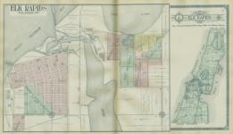
TABLE OF CONTENTS GENERfI L INDEX TITLE PAGE...................................... TABLE OF CONTENTS.............................. OUTLINE MAP OF ANTRIM COUNTY............... MAP OF THE STATE OF MICHIGAN.............. MAP OF THE UNITED STATES...................... MAP OF THE WORLD............................. PATRONS' REFERENCE DIRECTORY OF ANTRIM COUNTY.................................... ILLUSTRATIONS...................................... PAGE.........3....... a........ 7...68-69..... 72-73..... 76-77..S3 PAGE ANALYSIS OF THE SYSTEM OF UNITED STATES LAND SURVEYS............................Supplement 1-11 DIGEST OF THE SYSTEM OF CIVIL GOVERNMENT.... Supplement.................................... III-VI GENERAL INFORMATION REGARDING BANKING AND BUSINESS METHODS.................. Supplement VII-VII1 ANCIENT, MEDIEVAL AND MODERN HISTORY, CHRONOLOGICALLY ARRANGED...... Supplement X-XXII fANTRIM COUNTY INDEOX. PAGE ALBA, PLAT OF............................ 23 ALDEN, PLAT OF............................ 22-23 ALDEN PARK, PLAT OF..........................22 ANTRIM COUNTY, OUTLINE MAP OF...............7 ATWOOD, PLAT OF............................... 23 BANKS TOWNSHIP............................29 BELLAIRE, PLAT OF............................10-11 BIRCH POINT, PLAT OF..........................23 CENTRAL LAKE, PLAT OF........................18-19 CENTRAL LAKE TOWNSHIP......................... 35 CHANEY'S COVE, PLAT OF........................ 27 CHERRY GROVE, PLAT OF........................26 CHESTONIA TOWNSHIP.......................... 45 CUSTER TOWNSHIP............................61 DO-DI-AH-TA, PLAT OF........................... 27 EASTPORT, PLAT OF...............................15 ECHO TOWNSHIP................................. 37 ELK RAPIDS, PLAT OF.......................56-57 ELK RAPIDS TOWNSHIP.........................57 ELMIRA, PLAT OF................................ 32 ELLSWORTH, PLAT OF.................... 33 FOREST HOME TOWNSHIP............................49 FURNACEVILLE, PLAT OF....................... 15 HARBOR BEACH, PLAT OF..................... 26 HELENA TOWNSHIP................................ 59 PAGE INDIAN LANDING, PLAT OF....................33 JORDAN TOWNSHIP........................... 39 KEARNEY TOWNSHIP........................ 47 KEWADIN. PLAT OF.............................19 LYON RESORT. PLAT OF...........................11 MANCELONA, PLAT OF................... 14-15 MANCELONA TOWNSHIP...................... 64-65 MAY BLOOM BEACH, PLAT OF....................26 MILTON TOWNSHIP........................52-53 NEW HIGHLANDS. PLAT OF........................27 OLD ELLSWORTH, PLAT OF........................ 23 PRAY'S HARBOR, PLAT OF................26-27 REX TERRACE, PLAT OF..........................19 SIMONS, PLAT OF.............................. 11 SNOWFLAKE. PLAT OF.............................11 SPENCER CREEK, PLAT OF........................22 STAR TOWNSHIP................................ 43 TORCH LAKE, PLAT OF......................... 27 TORCH LAKE RESORTS, PLAT OF................ 26-27 TORCH LAKE TOWNSHIP........................ 32-33 WARNER TOWNSHIP..................................41 WA-SE-O TERRACE, PLAT OF.....................26 WASWAHGONINK, PLAT OF........................26 WETZELL, PLAT OF..........................32-33 WIG-WASH-MISH RESORT, PLAT OF................26
-
Scan 1

Page #1 - Front Matter
-
Scan 2

Page #2 - Front Matter
-
Scan 3

Page 1
-
Scan 4

Page 2
-
Scan 5

Page 3 - Title Page
-
Scan 6

Page 4
-
Scan 7

Page 5 - Table of Contents
-
Scan 8

Page 6 - List of Illustrations
-
Scan 9

Page 7
-
Scan 10

Page 8
-
Scan 11

Page 9
-
Scan 12

Page 10-11
-
Scan 13

Page 12
-
Scan 14

Page 13
-
Scan 15

Page 14-15
-
Scan 16

Page 16
-
Scan 17

Page 17
-
Scan 18

Page 18-19
-
Scan 19

Page 20
-
Scan 20

Page 21
-
Scan 21

Page 22-23
-
Scan 22

Page 24
-
Scan 23

Page 25
-
Scan 24

Page 26-27
-
Scan 25

Page 28
-
Scan 26

Page 29
-
Scan 27

Page 30
-
Scan 28

Page 31
-
Scan 29

Page 32-33
-
Scan 30

Page 34
-
Scan 31

Page 35
-
Scan 32

Page 36
-
Scan 33

Page 37
-
Scan 34

Page 38
-
Scan 35

Page 39
-
Scan 36

Page 40
-
Scan 37

Page 41
-
Scan 38

Page 42
-
Scan 39

Page 43
-
Scan 40

Page 44
-
Scan 41

Page 45
-
Scan 42

Page 46
-
Scan 43

Page 47
-
Scan 44

Page 48
-
Scan 45

Page 49
-
Scan 46

Page 50
-
Scan 47

Page 51
-
Scan 48

Page 52-53
-
Scan 49

Page 54
-
Scan 50

Page 55
-
Scan 51
Page 56-57
-
Scan 52

Page 58
-
Scan 53

Page 59
-
Scan 54

Page 60
-
Scan 55

Page 61
-
Scan 56

Page 62
-
Scan 57

Page 63
-
Scan 58

Page 64-65
-
Scan 59

Page 66
-
Scan 60

Page 67
-
Scan 61

Page 68-69
-
Scan 62

Page 70
-
Scan 63

Page 71
-
Scan 64

Page 72-73
-
Scan 65

Page 74
-
Scan 66

Page 75
-
Scan 67

Page 76-77
-
Scan 68

Page 78
-
Scan 69

Page 79
-
Scan 70

Page 80
-
Scan 71

Page 81
-
Scan 72

Page 82
-
Scan 73

Page 83
-
Scan 74

Page 84
-
Scan 75

Page 85
-
Scan 76

Page 86
-
Scan 77

Page 87
-
Scan 78

Page 88
-
Scan 79

Page 89
-
Scan 80

Page 90
-
Scan 81

Page I
-
Scan 82

Page II
-
Scan 83

Page III
-
Scan 84

Page IV
-
Scan 85

Page V
-
Scan 86

Page VI
-
Scan 87

Page VII
-
Scan 88

Page VIII
-
Scan 89

Page X
-
Scan 90

Page XI
-
Scan 91

Page XII
-
Scan 92

Page XIII
-
Scan 93

Page XIV
-
Scan 94

Page XV
-
Scan 95

Page XVI
-
Scan 96

Page XVII
-
Scan 97

Page XVIII
-
Scan 98
Page XIX
-
Scan 99

Page XX
-
Scan 100

Page XXI
-
Scan 101

Page XXII
-
Scan 102

Page #102
-
Scan 103

Page #103
-
Scan 104

Page #104
-
Scan 105

Page #105
-
Scan 106

Page #106
About this Item
- Title
- Standard atlas of Antrim County, Michigan : including a plat book of the villages, cities and townships of the county...patrons directory, reference business directory and departments devoted to general information / compiled and published by Geo. A. Ogle & Co.
- Author
- Geo. A. Ogle & Co.
- Canvas
- Page 5 - Table of Contents
- Publication
- Chicago :: Geo. A. Ogle & Co.,
- 1910.
- Subject terms
- Real property -- Maps. -- Michigan
- Landowners -- Maps. -- Michigan
- Antrim County (Mich.) -- Maps.
- Atlases
Technical Details
- Collection
- Michigan County Histories and Atlases
- Link to this Item
-
https://name.umdl.umich.edu/2897685.0001.001
- Link to this scan
-
https://quod.lib.umich.edu/m/micounty/2897685.0001.001/7
Rights and Permissions
The University of Michigan Library provides access to these materials for educational and research purposes. These materials are believed to be in the public domain in the United States; however, if you decide to use any of these materials, you are responsible for making your own legal assessment and securing any necessary permission.
DPLA Rights Statement: No Copyright - United States
Related Links
IIIF
- Manifest
-
https://quod.lib.umich.edu/cgi/t/text/api/manifest/micounty:2897685.0001.001
Cite this Item
- Full citation
-
"Standard atlas of Antrim County, Michigan : including a plat book of the villages, cities and townships of the county...patrons directory, reference business directory and departments devoted to general information / compiled and published by Geo. A. Ogle & Co." In the digital collection Michigan County Histories and Atlases. https://name.umdl.umich.edu/2897685.0001.001. University of Michigan Library Digital Collections. Accessed June 13, 2025.