Archaeological atlas of Michigan [by] Wilbert B. Hinsdale...
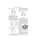
SAN I LAC-WAYNE streams are several miles long, the items are too vague to justify charting. The county contains village, mound, and burying ground sites, distributed in several townships, as the map indicates. It is regrettable that the data upon the archaeology of this part of the state were not sufficiently exact to render it possible to delineate more fully the situations described. SITES IDENTIFIED Villages --------- 9 Burying grounds ---- 6 Mounds -----------17 Circular inclosure --- 1 TOWNSHIPS A mile northeast of this site a low mound sixty feet in diameter yielded several skeletons of adults and children, pottery, firestones, and many kinds of implements. By the Saline River, near the village of Saline, there were salt springs and evidences of salt-making. A pot that held eight gallons, a very remarkable size, is reported to have been found at these "works." In the early pioneer times there could be seen a row of stepping-stones across the Huron River eighty rods below the outlet of Portage Lake, about on the line between Dexter and Webster townships, a mile south of the county boundary. The stones were so placed that one could cross the river dry-shod except during very high water. The location of Washtenaw sites, so far as determined, can readily be perceived on the map. Important trails traversed the county. At one time the Wyandots had a village at Ypsilanti. SITES IDENTIFIED Villages ----------- 8 Burying grounds 2 Mounds ------------5 TOWNSHIPS 1. 2. 3. 4. 5. 6. 7. 8. 9. 10. 11. Wisner Akron Columbia Elmwood Elkland Gilford Fair Grove Almer Ellington Novesta Denmark 13. 14. 15. 16. 17. 18. 19. 20. 21. 22. 23. Indianfield Wells Kingston Tuscola Vassar Fremont Dayton Koylton Arbela Millington Watertown 12. Juniata VAN BUREN COUNTY (Map 4) The lakes of Lawrence and Paw Paw townships were attractive to the Indians, probably on account of the fishing and excellent hunting grounds. Not less than fourteen mound sites have been located in Paw Paw Township. Many of the mounds were arranged in groups. There was also a group of seven mounds in the southeast corner of Decatur Township, Section 36, upon the east side of Swift's Lake. Just south of this group in the SE. 4 of the SE. y of the section, an ancient village stood, and across the lake to the west an old ossuary has been identified. Mr. Dana P. Smith, of Paw Paw, has given valuable assistance in tracing trails and locating sites in the southwestern counties of the state. Acknowledgment is also made to Mr. W. L. Marshall, Science Department, South Lake High School, St. Clair Shores, for field surveys of several townships. SITES IDENTIFIED Villages -----------14 Burying grounds 4 Mounds -----------37 Garden beds------- 3 TOWNSHIPS 1. 2. 3. 4. 5. 6. 7. 8. 9. 10. Lyndon Dexter Webster Northfield Salem Sylvan Lima Scio Ann Arbor Superior 11. 12. 13. 14. 15. 16. 17. 18. 19. 20. Sharon Freedom Lodi Pittsfield Ypsilanti Manchester Bridgewater Saline York Augusta WAYNE COUNTY (Map 6) Upon the Detroit River, within the present limits of Detroit, there was a cluster of not less than four Indian villages. Four other villages were situated below the mouth of River Rouge, upon or near the Detroit River shore. Several settlements lay across the river upon the Canadian side. Most of these sites upon both sides were occupied in historic times by Ottawa, Potawatomi, and Wyandots. A group of Wyandot villages was located upon a reservation of 4,996 acres in the eastern part of Huron Township. The Potawatomi Trail, which followed the Huron River from its mouth through Wayne and Washtenaw counties and on to the northwest, passed the reservation. 1. 2. 3. 4. 5. 6. 7. 8. 9. South Haven Geneva Columbia Bloomingdale Pine Grove Covert Bangor Arlington Waverly 10. 11. 12. 13. 14. 15. 16. 17. 18. Almena Hartford Lawrence Paw Paw Antwerp Keeler Hamilton Decatur Porter WASHTENAW COUNTY (Map 6) In the southwest quarter of Section 23, Ann Arbor Township, three mounds upon a high bank overlooked the Huron River. From one of these there were exhumed the entire skeleton of an adult male, two pieces of pottery of the Algonquian type, and numerous artifacts, some of which were of copper. The capacity of each pot was six quarts. One contained hundreds of shells which conchologists identified as coming from the Gulf of Mexico. The other vessel had in it the skeleton of a beaver. -, '-... ~i^^ , .---^' --v,^T,,",,',w. FIG. 21. The "Great Springwells Mound" which mouth of River Rouge stood at Del Rey, Judge Alpheus Felch located one of the villages of the diplomatic Wyandot chief, Walk-in-the-Water, "near the bank of the Detroit River a short distance below the present village of Trenton." Monguagon village was at about the southern limits of the -37 -
-
Scan 1

Page #1 - Front Matter
-
Scan 2

Page #2 - Front Matter
-
Scan 3

Page #3 - Title Page
-
Scan 4

Page #4
-
Scan 5
Page #5 - Table of Contents
-
Scan 6
Page #6 - List of Illustrations
-
Scan 7

Page #7 - Comprehensive Index
-
Scan 8

Page #8
-
Scan 9

Page 1
-
Scan 10

Page 2
-
Scan 11

Page 3
-
Scan 12

Page 4
-
Scan 13

Page 5
-
Scan 14

Page 6
-
Scan 15

Page 7
-
Scan 16

Page 8
-
Scan 17

Page 9
-
Scan 18

Page 10
-
Scan 19

Page 11
-
Scan 20

Page 12
-
Scan 21

Page 13
-
Scan 22

Page 14
-
Scan 23

Page 15
-
Scan 24

Page 16
-
Scan 25

Page 17
-
Scan 26

Page 18
-
Scan 27

Page 19
-
Scan 28

Page 20
-
Scan 29

Page 21
-
Scan 30

Page 22
-
Scan 31

Page 23
-
Scan 32

Page 24
-
Scan 33
Page 25
-
Scan 34

Page 26
-
Scan 35

Page 27
-
Scan 36

Page 28
-
Scan 37

Page 29
-
Scan 38

Page 30
-
Scan 39
Page 31
-
Scan 40

Page 32
-
Scan 41

Page 33
-
Scan 42

Page 34
-
Scan 43

Page 35
-
Scan 44

Page 36
-
Scan 45

Page 37
-
Scan 46

Page 38
-
Scan 47

Page #47
-
Scan 48

Page #48
-
Scan 49

Page #49
-
Scan 50

Page #50
-
Scan 51

Page #51
-
Scan 52

Page #52
-
Scan 53

Page #53
-
Scan 54

Page #54
-
Scan 55

Page #55
-
Scan 56

Page #56
-
Scan 57

Page #57
-
Scan 58

Page #58
-
Scan 59

Page #59
-
Scan 60

Page #60
-
Scan 61

Page #61
-
Scan 62

Page #62
-
Scan 63

Page #63
-
Scan 64

Page #64
-
Scan 65

Page #65
-
Scan 66

Page #66
-
Scan 67

Page #67
-
Scan 68

Page #68
-
Scan 69

Page #69
-
Scan 70

Page #70
-
Scan 71

Page #71
-
Scan 72

Page #72
-
Scan 73

Page #73
-
Scan 74

Page #74
-
Scan 75

Page #75
-
Scan 76

Page #76
-
Scan 77

Page #77
-
Scan 78

Page #78
-
Scan 79

Page #79
-
Scan 80

Page #80
-
Scan 81

Page #81
-
Scan 82

Page #82
-
Scan 83

Page #83
-
Scan 84

Page #84
-
Scan 85

Page #85
-
Scan 86

Page #86
-
Scan 87

Page #87
-
Scan 88

Page #88
-
Scan 89

Page #89
-
Scan 90

Page #90
-
Scan 91

Page #91
-
Scan 92

Page #92
-
Scan 93

Page #93
-
Scan 94

Page #94
About this Item
- Title
- Archaeological atlas of Michigan [by] Wilbert B. Hinsdale...
- Author
- Hinsdale, W. B. (Wilbert B.), 1851-1944.
- Canvas
- Page 37
- Publication
- Ann Arbor,: University of Michigan press,
- 1931.
- Subject terms
- Indians of North America -- Michigan
- Names, Geographical -- Michigan.
- Michigan -- Antiquities
- Michigan -- Description and travel
Technical Details
- Collection
- Digital General Collection
- Link to this Item
-
https://name.umdl.umich.edu/1265156.0001.001
- Link to this scan
-
https://quod.lib.umich.edu/g/genpub/1265156.0001.001/45
Rights and Permissions
Where applicable, subject to copyright. Other restrictions on distribution may apply. Please go to http://www.umdl.umich.edu/ for more information.
Related Links
IIIF
- Manifest
-
https://quod.lib.umich.edu/cgi/t/text/api/manifest/genpub:1265156.0001.001
Cite this Item
- Full citation
-
"Archaeological atlas of Michigan [by] Wilbert B. Hinsdale..." In the digital collection Digital General Collection. https://name.umdl.umich.edu/1265156.0001.001. University of Michigan Library Digital Collections. Accessed June 12, 2025.