Archaeological atlas of Michigan [by] Wilbert B. Hinsdale...
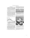
ARCHAEOLOGICAL FEATURES OF THE COUNTIES 14), taken from Mr. Bela Hubbard's Memorials of a Half-Century, shows an inclosure upon Section 3, Bruce Township, of nearly three acres, with three gateways, a mound upon the inside of each one, and a pool. In the immediate vicinity, upon both sides of the north branch of Clinton River, there were nineteen mounds in close proximity to each other, making in all twenty-two mounds, besides the "fort," upon one square mile. ~~____~_________~ ~Mr. Bela Hubbard also refers to mounds S built of stones, "nice"4 or,. ly piled up to a height / Kf of four feet," standZ J{0 0 ing alone. Skeletons;5) tha a ml400 Fe f o th | ACRC were found u n d e r l some which were more S4 than a mile from the / earthworks. The di/15 FECT ABOVC R/VCR ^// '. i *. I,,_rection and situation, k/!' -.. however, are so inw,. - E ]definite that they are 1 &-7 -, not charted. It is im-,, t%.,n;;.4 portant to call attenN'.,\i,,.- tion to stone-pile,:, 4,11,,ht,to mounds because they A ^^^were not reported $4' @1fo from elsewhere in the state....I. '1iV,,' -As the map indi"-; cates, there were other "4 inclosures, circular, and rectangular, _______________________ within four miles to FIG. 14. Diagram of ancient earthworks, the south and east of Macomb County. From Bela Hubbard, this site. According Memorials of a Half-Century to reports, the circular inclosure near the mouth of the Clinton contained three acres. There were two groups of mounds upon or very near the south line of the county, and mounds stood upon the west side of Bear Lake. SITES IDENTIFIED Villages ----------- 6 Burying grounds _ 5 Mounds ----------11 1. 2. 3. 4. 5. 6. 7. TOWNSHIPS Arcadia 8. Pleasanton 9. Springdale 10. Cleon 11. Onekama 12. Bear Lake 13. Maple Grove 14. Marilla Manistee Brown Dickson Filer Stronach Norman MARQUETTE COUNTY (Map 18) Within an area extending from the mouth of Chocolay River to Presque Isle Point, a distance of eight miles mostly within the limits of what is now the city of Marquette, there were six Indian villages and two burying grounds. Another village was located in Powell Township, at the mouth of Cliff River, near the end of a forty-mile trail from the village at the mouth of Chocolay River. If records of observations had been kept in early times, and if they were available, many other sites could be placed on the map. A trail led west from the village where Marquette now stands, along the north side of Lake Michigamme to L'Anse, at the head of Keweenaw Bay. This trail divided near Negaunee; the two paths ran parallel to unite again at Lake Michigamme. There was a canoe passage from Lake Michigamme down the river of the same name to the Menominee. A greater part of the information upon which this report and the map are based has been obtained from correspondence, in 1893, between the Hon. Peter White of Marquette and the Hon. L. D. Watkins of Manchester. Professor L. A. Chase of Marquette has also rendered valuable assistance. SITES IDENTIFIED Villages ---------- 7 Burying grounds _ 2 TOWNSHIPS 1. Powell 11. Richmond 2. Michigamme 12. Sands 3. Champion 13. Chocolay 4. Ishpeming 14. West Branch 5. Marquette 15. Skandia 6. Negaunee 16. Forsyth 7. Republic 17. Turin 8. Humboldt 18. Wells 9. Ely 19. Ewing SITES IDENTIFIED Villages ----------------- 8 Burying grounds ---------4 Mounds ---------------26 Circular inclosures -------8 Rectangular inclosure _ 1 TOWNSHIPS 1. 2. 3. 4. 5. 6. 7. 8. Bruce Armada Richmond Washington Ray Lenox Shelby Macomb 9. 10. 11. 12. 13. 14. 15. Chesterfield Sterling Clinton Harrison Warren Erin Lake 10. Tilden v MANISTEE COUNTY (Map 11) Four villages, two burial sites, and a mound are known to have been situated near the mouths of the Manistee and Little Manistee rivers, some of them within the present limits of the city of Manistee. As the map shows, there were other sites in different parts of the county. The trail from the mouth of the Manistee River to Otsego Lake is referred to in the comments upon Otsego County. There was a trail from the mouth of the Manistee to the outlet of Portage Lake. According to the most reliable data, the Mackinaw and St. Joseph trail, which is designated by broken lines, passed around the head of Portage Lake. MASON COUNTY (Map 11) The Big Sable, the Little Sable, and the Pere Marquette rivers, which cross Mason County from east to west and discharge into Lake Michigan, were canoe routes to and from numerous sites along their banks. The map locates thirteen villages and nine mounds upon or near the Pere Marquette and the Lake that bears the same name, the latter being merely a widening of the river at its outlet. Several sites are marked upon the borders of Lower Hamlin Lake, which is also an estuary-like part of Big Sable. There must have been trails paralleling the water courses for use when storm, flood, and ice made canoeing impossible. The dunes along the Lake Michigan shore had an influence upon the Indians who frequented them during the warmer weather and abandoned them for winter quarters farther back in the country and up the rivers to be away from lake tempests and drifting snow and sand. -28 -
-
Scan 1

Page #1 - Front Matter
-
Scan 2

Page #2 - Front Matter
-
Scan 3

Page #3 - Title Page
-
Scan 4

Page #4
-
Scan 5
Page #5 - Table of Contents
-
Scan 6
Page #6 - List of Illustrations
-
Scan 7

Page #7 - Comprehensive Index
-
Scan 8

Page #8
-
Scan 9

Page 1
-
Scan 10

Page 2
-
Scan 11

Page 3
-
Scan 12

Page 4
-
Scan 13

Page 5
-
Scan 14

Page 6
-
Scan 15

Page 7
-
Scan 16

Page 8
-
Scan 17

Page 9
-
Scan 18

Page 10
-
Scan 19

Page 11
-
Scan 20

Page 12
-
Scan 21

Page 13
-
Scan 22

Page 14
-
Scan 23

Page 15
-
Scan 24

Page 16
-
Scan 25

Page 17
-
Scan 26

Page 18
-
Scan 27

Page 19
-
Scan 28

Page 20
-
Scan 29

Page 21
-
Scan 30

Page 22
-
Scan 31

Page 23
-
Scan 32

Page 24
-
Scan 33
Page 25
-
Scan 34

Page 26
-
Scan 35

Page 27
-
Scan 36

Page 28
-
Scan 37

Page 29
-
Scan 38

Page 30
-
Scan 39
Page 31
-
Scan 40

Page 32
-
Scan 41

Page 33
-
Scan 42

Page 34
-
Scan 43

Page 35
-
Scan 44

Page 36
-
Scan 45

Page 37
-
Scan 46

Page 38
-
Scan 47

Page #47
-
Scan 48

Page #48
-
Scan 49

Page #49
-
Scan 50

Page #50
-
Scan 51

Page #51
-
Scan 52

Page #52
-
Scan 53

Page #53
-
Scan 54

Page #54
-
Scan 55

Page #55
-
Scan 56

Page #56
-
Scan 57

Page #57
-
Scan 58

Page #58
-
Scan 59

Page #59
-
Scan 60

Page #60
-
Scan 61

Page #61
-
Scan 62

Page #62
-
Scan 63

Page #63
-
Scan 64

Page #64
-
Scan 65

Page #65
-
Scan 66

Page #66
-
Scan 67

Page #67
-
Scan 68

Page #68
-
Scan 69

Page #69
-
Scan 70

Page #70
-
Scan 71

Page #71
-
Scan 72

Page #72
-
Scan 73

Page #73
-
Scan 74

Page #74
-
Scan 75

Page #75
-
Scan 76

Page #76
-
Scan 77

Page #77
-
Scan 78

Page #78
-
Scan 79

Page #79
-
Scan 80

Page #80
-
Scan 81

Page #81
-
Scan 82

Page #82
-
Scan 83

Page #83
-
Scan 84

Page #84
-
Scan 85

Page #85
-
Scan 86

Page #86
-
Scan 87

Page #87
-
Scan 88

Page #88
-
Scan 89

Page #89
-
Scan 90

Page #90
-
Scan 91

Page #91
-
Scan 92

Page #92
-
Scan 93

Page #93
-
Scan 94

Page #94
About this Item
- Title
- Archaeological atlas of Michigan [by] Wilbert B. Hinsdale...
- Author
- Hinsdale, W. B. (Wilbert B.), 1851-1944.
- Canvas
- Page 28
- Publication
- Ann Arbor,: University of Michigan press,
- 1931.
- Subject terms
- Indians of North America -- Michigan
- Names, Geographical -- Michigan.
- Michigan -- Antiquities
- Michigan -- Description and travel
Technical Details
- Collection
- Digital General Collection
- Link to this Item
-
https://name.umdl.umich.edu/1265156.0001.001
- Link to this scan
-
https://quod.lib.umich.edu/g/genpub/1265156.0001.001/36
Rights and Permissions
Where applicable, subject to copyright. Other restrictions on distribution may apply. Please go to http://www.umdl.umich.edu/ for more information.
Related Links
IIIF
- Manifest
-
https://quod.lib.umich.edu/cgi/t/text/api/manifest/genpub:1265156.0001.001
Cite this Item
- Full citation
-
"Archaeological atlas of Michigan [by] Wilbert B. Hinsdale..." In the digital collection Digital General Collection. https://name.umdl.umich.edu/1265156.0001.001. University of Michigan Library Digital Collections. Accessed June 12, 2025.