Archaeological atlas of Michigan [by] Wilbert B. Hinsdale...
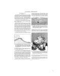
H URON-KALAMAZOO tip of Tawas Point, and two or three burying places have been located in the county. SITES IDENTIFIED Villages ---------- 4 Burying grounds 2 Mound ----------- 1 1. 2. 3. 4. 5. 6. TOWNSHIPS Plainfield 7. Tawas Oscoda 8. Baldwin Wilber 9. Burleigh Au Sable 10. Sherman Reno 11. Alabaster Grant JACKSON COUNTY (Map 5) A methodical survey does not indicate the existence of many earthworks. Village sites were numerous, and every township except Hanover and Pulaski was crossed by a trail. A complete record, which at this date is impossible, would presumably add many interesting features to the map. Acknowledgment is made to Mr. W. C. Fargo, of Jackson, and Mr. N. F. Wing, of Grass Lake, for valuable assistance in tracing the trails and locating sites in the county. SITES IDENTIFIED Villages -----------23 Burying grounds -- 4 Mounds -----------3 IRON COUNTY (Map 16) There is not much of archaeological interest to report from this large county, although the topography indicates it must have had seasonal attractions for fishers, hunters, and trappers. A trail from L'Anse, Baraga County, came south to the lake region of Iron County, past Chicagon Lake, and crossed Brule River into Wisconsin. A mile west of Swan Lake this trail was met by one coming south from the Indian village on Lake Michigamme, in Marquette County. There were a good many branches from these main trails. Parts of some of the old trails can still be seen and traced for considerable distances. Acknowledgment is made of valuable services rendered by Mr. H. F. Larson, county engineer, Crystal Falls, who assisted in preparing the map, in locating several sites, and in tracing the trails. SITES IDENTIFIED Villages -----------4 Burying grounds 4 TOWNSHIPS 1. Stambaugh 5. Crystal Falls 2. Iron River 6. Mansfield 3. Bates 7. Mastodon 4. Hematite ISABELLA COUNTY (Map 8) According to the records so far obtained, there were three mounds in a group upon the west border of Coldwater Township; in Vernon, two mounds; in Sherman, a village; in Denver, a village; in Union, a village and a burying ground; in Lincoln, a group of mounds the number of which is undetermined, and also a group of three, a group of two, and two isolated mounds, two villages, and two burying grounds. A trail ran from Shingquacaseking, two miles below Mount Pleasant, on the north side of the Chippewa River, to the junction of the Chippewa and the Tittabawassee rivers in Midland County. A trail which cannot be accurately located for its entire course passed diagonally across the county from Coe through Shepherd and Mt. Pleasant and left the county about six miles east of the northwest corner. SITES IDENTIFIED Villages -----------5 Burying grounds 3 Mounds --------- 13 1 TOWNSHIPS 1. Springport 11. ( 2. Tompkins 12. S 3. Rives 13. S 4. Henrietta 14. bs 5. Waterloo 15. F 6. Parma 16. F 7. Sandstone 17. I 8. Blackman 18. ( 9. Leoni 19. s 0. Grass Lake 4oncord;pring Arbor 5ummit STapoleon Dulaski lanover 4iberty rolumbia,orvell KALAMAZOO COUNTY (Map 4) A conspicuous and unique feature of Michigan's antiquities is the "garden bed" construction. The beds were symmetrical, low earth ridges, as described in the chapter upon "Garden Beds." One which was situated in the city of Kalamazoo, where the Park Club House now stands, was wheel-shaped, with "spokes" run Fr..Oulneso nin adn bed~oos O 0 0= Do i DU Lin Ni U U rzzz QOOO EzE36 _ __j L:-. n LEDFnn FIG. 8. Outlines of ancient garden beds 1. 2. 3. 4. 5. 6. 7. 8. TOWNSHIPS Coldwater 9. Gilmore, 10. Vernon 11. Wise 12. Sherman 13. Nottawa 14. Isabella 15. Denver 16. Broomfield Deerfield Union Chippewa Rolland Fremont Lincoln Coe ning out from an inner to an outer circular ridge. Others were " gridiron"-shaped, in regular straight-line designs with numerous ridges paralleling each other at a distance apart of about three feet. One or two of them were of quite complicated pattern, but very regular and formal (see Figure 8). More of these beds existed in Kalamazoo County than in all the rest of the state, although the largest, covering one hundred and twenty acres, was near Three Rivers, in St. Joseph County. -^
-
Scan 1

Page #1 - Front Matter
-
Scan 2

Page #2 - Front Matter
-
Scan 3

Page #3 - Title Page
-
Scan 4

Page #4
-
Scan 5
Page #5 - Table of Contents
-
Scan 6
Page #6 - List of Illustrations
-
Scan 7

Page #7 - Comprehensive Index
-
Scan 8

Page #8
-
Scan 9

Page 1
-
Scan 10

Page 2
-
Scan 11

Page 3
-
Scan 12

Page 4
-
Scan 13

Page 5
-
Scan 14

Page 6
-
Scan 15

Page 7
-
Scan 16

Page 8
-
Scan 17

Page 9
-
Scan 18

Page 10
-
Scan 19

Page 11
-
Scan 20

Page 12
-
Scan 21

Page 13
-
Scan 22

Page 14
-
Scan 23

Page 15
-
Scan 24

Page 16
-
Scan 25

Page 17
-
Scan 26

Page 18
-
Scan 27

Page 19
-
Scan 28

Page 20
-
Scan 29

Page 21
-
Scan 30

Page 22
-
Scan 31

Page 23
-
Scan 32

Page 24
-
Scan 33
Page 25
-
Scan 34

Page 26
-
Scan 35

Page 27
-
Scan 36

Page 28
-
Scan 37

Page 29
-
Scan 38

Page 30
-
Scan 39
Page 31
-
Scan 40

Page 32
-
Scan 41

Page 33
-
Scan 42

Page 34
-
Scan 43

Page 35
-
Scan 44

Page 36
-
Scan 45

Page 37
-
Scan 46

Page 38
-
Scan 47

Page #47
-
Scan 48

Page #48
-
Scan 49

Page #49
-
Scan 50

Page #50
-
Scan 51

Page #51
-
Scan 52

Page #52
-
Scan 53

Page #53
-
Scan 54

Page #54
-
Scan 55

Page #55
-
Scan 56

Page #56
-
Scan 57

Page #57
-
Scan 58

Page #58
-
Scan 59

Page #59
-
Scan 60

Page #60
-
Scan 61

Page #61
-
Scan 62

Page #62
-
Scan 63

Page #63
-
Scan 64

Page #64
-
Scan 65

Page #65
-
Scan 66

Page #66
-
Scan 67

Page #67
-
Scan 68

Page #68
-
Scan 69

Page #69
-
Scan 70

Page #70
-
Scan 71

Page #71
-
Scan 72

Page #72
-
Scan 73

Page #73
-
Scan 74

Page #74
-
Scan 75

Page #75
-
Scan 76

Page #76
-
Scan 77

Page #77
-
Scan 78

Page #78
-
Scan 79

Page #79
-
Scan 80

Page #80
-
Scan 81

Page #81
-
Scan 82

Page #82
-
Scan 83

Page #83
-
Scan 84

Page #84
-
Scan 85

Page #85
-
Scan 86

Page #86
-
Scan 87

Page #87
-
Scan 88

Page #88
-
Scan 89

Page #89
-
Scan 90

Page #90
-
Scan 91

Page #91
-
Scan 92

Page #92
-
Scan 93

Page #93
-
Scan 94

Page #94
About this Item
- Title
- Archaeological atlas of Michigan [by] Wilbert B. Hinsdale...
- Author
- Hinsdale, W. B. (Wilbert B.), 1851-1944.
- Canvas
- Page 23
- Publication
- Ann Arbor,: University of Michigan press,
- 1931.
- Subject terms
- Indians of North America -- Michigan
- Names, Geographical -- Michigan.
- Michigan -- Antiquities
- Michigan -- Description and travel
Technical Details
- Collection
- Digital General Collection
- Link to this Item
-
https://name.umdl.umich.edu/1265156.0001.001
- Link to this scan
-
https://quod.lib.umich.edu/g/genpub/1265156.0001.001/31
Rights and Permissions
Where applicable, subject to copyright. Other restrictions on distribution may apply. Please go to http://www.umdl.umich.edu/ for more information.
Related Links
IIIF
- Manifest
-
https://quod.lib.umich.edu/cgi/t/text/api/manifest/genpub:1265156.0001.001
Cite this Item
- Full citation
-
"Archaeological atlas of Michigan [by] Wilbert B. Hinsdale..." In the digital collection Digital General Collection. https://name.umdl.umich.edu/1265156.0001.001. University of Michigan Library Digital Collections. Accessed June 12, 2025.