Archaeological atlas of Michigan [by] Wilbert B. Hinsdale...
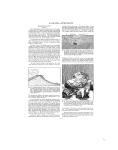
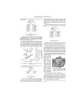
ARCHAEOLOGICAL FEATURES OF THE COUNTIES walk. Two or three miles west of Franklin Mine a farmer turned out with his plow, in two summers, over a ton of float copper. One mass collected by this gentleman weighs four hundred and eighty-four pounds; and upon one side its contour resembles the profile of a human face (Figure 7); it is now among the exhibits of the Museum of Mineralogy of the University. There is a tradition, which is probably more fiction than fact, that a bloody battle was fought between Iroquois and Chippewa at Battle Island near the Portage entry about the year 1730. See notes upon Keweenaw and Ontonagon counties. SITES IDENTIFIED Villages ----------------------- 2 Mines, pits (copper).--very numerous with the Grand River, near Michigan State College campus. Several Indian sites and cornfields are known to have been situated along this line. Two clusters of mounds are designated upon the map of this county, one in Leslie township, the other in Aurelius. Acknowledgment is made to Mr. E. C. Calkins, Department of Public Utilities, Lansing, for assistance in tracing the trails of this and adjoining counties. SITES IDENTIFIED Villages ------------7 Burying grounds -----4 Mounds ----------- 4 Circular inclosure __ 1 TOWNSHIPS 1. 2. 3. 4. 5. 6. 7. TOWNSHIPS Calumet 8. Hancock 9. Osceola 10. Schoolcraft 11. Quincy 12. Franklin 13. Stanton 14. Adams Torch Lake Chassell Elm River Portage Laird Duncan 1. 2. 3. 4. 5. 6. 7. 8. Lansing Meridian Williamston Locke Delhi Alaiedon Wheatfield Le Roy 9. 10. 11. 12. 13. 14. 15. 16. Aurelius Vevay Ingham White Oak Onondaga Leslie Bunker Hill Stockbridge HURON COUNTY (Map 10) Huron County has a straight-line boundary upon the south side, which is about forty-five miles long. Upon the shore line of eighty-five miles were numerous villages and camps, as is attested by the debris left by the dwellers. There is a village site every few miles along the shore of Saginaw Bay. A few small islands in the bay also have remains of villages and mounds. The remnants of mounds that have been mutilated by relic hunters are visible within a mile east of Port Austin and upon New River, near its mouth. A mound group was situated in the southeastern part of Sheridan Township, near the southern boundary of the county, but the section upon which it stood could not be ascertained. Mr. Harlan I. Smith, of Victoria Memorial Museum, Ottawa, Canada, who made a survey of the tThumb" district, reported in 1901 that a number of small mounds stood upon Katechay Island, Fair Haven Township. There is an old record of a circular inclosure where the courthouse at Bad Axe stands. Traces of workshops and camps,Are still to be found along the Lake Huron shore. A trail followed the shore from Oak Point, and a "ferry line" crossed the bay for Point Lookout with a stopping-place at Charity Island. SITES IDENTIFIED Villages -------------13 Burying grounds ----- 7 Mounds ------------- 7 Circular inclosure _. 1 TOWNSHIPS IONIA COUNTY (Map 8) The banks and valleys of the Grand, Maple, Lookingglass, and Flat rivers afforded subsistence and occupation for a numerous Indian population. At least five villages were located in Danby Township; one lay just across the north line in Portland. A group of several mounds was situated on the Lookingglass, a mile east of the village of Portland. There were three mounds in close proximity to each other upon the edge of the village of Muir. In Section 34, Lyons Township, three mounds stood close together. A half mile west of Muir is Arthurberg Hill. A line of embankments around the north and east sides of the hill inclosed several acres; the curved, steep banks of the Maple formed a barrier on the other sides. The walls of earth were originally double for a part, if not all, of the way. This eminence, overlooking the low ground across and to the south of the river for a mile or more, was a quite formidable defense. As mentioned in the notes upon St. Joseph County, "hill-top forts" were not common in Michigan. SITES IDENTIFIED. Villages -----------12 Burying grounds 4 Mounds -----------11 Earthwork --------1 TOWNSHIPS 1. Port Austin 15. Winsor 2. 3. 4. 5. 6. 7. 8. 9. 10. 11. 12. 13. 14. Caseville Lake Hume Dwight Huron Gore McKinley Chandler Meade Lincoln Bloomfield Rubicon Fair Haven 16. 17. 18. 19. 20. 21. 22. 23. 24. 25. 26. 27. Oliver Colf ax Verona Sigel Sand Beach Sebewaing Brookfield Grant Sheridan Bingham Paris Sherman 1. 2. 3. 4. 5. 6. 7. 8. Otisco Orleans Ronald North Plains Keene Easton lonia Lyons 9. 10. 11. 12. 13. 14. 15. 16. Boston Berlin Orange Portland Campbell Odessa Sebewa Danby INGHAM COUNTY (Map 5) The old Indian trail from the Detroit River to the mouth of the Grand crossed the northern part of Ingham County and followed the Cedar River the greater part of the way to its confluence IOSCO COUNTY (Map 12) The Lake Huron shore trail had a collateral that branched off at the mouth of the Au Sable River. On the map it abruptly terminates at Smith's Creek in southwestern Alcona County. No doubt it went much farther into the forests of the middle reaches of the Au Sable. Villages were situated at Tawas Point and upon the Au Sable, one of which was at the river's mouth. There was a mound at the -22--
-
Scan 1

Page #1 - Front Matter
-
Scan 2

Page #2 - Front Matter
-
Scan 3

Page #3 - Title Page
-
Scan 4

Page #4
-
Scan 5
Page #5 - Table of Contents
-
Scan 6
Page #6 - List of Illustrations
-
Scan 7

Page #7 - Comprehensive Index
-
Scan 8

Page #8
-
Scan 9

Page 1
-
Scan 10

Page 2
-
Scan 11

Page 3
-
Scan 12

Page 4
-
Scan 13

Page 5
-
Scan 14

Page 6
-
Scan 15

Page 7
-
Scan 16

Page 8
-
Scan 17

Page 9
-
Scan 18

Page 10
-
Scan 19

Page 11
-
Scan 20

Page 12
-
Scan 21

Page 13
-
Scan 22

Page 14
-
Scan 23

Page 15
-
Scan 24

Page 16
-
Scan 25

Page 17
-
Scan 26

Page 18
-
Scan 27

Page 19
-
Scan 28

Page 20
-
Scan 29

Page 21
-
Scan 30

Page 22
-
Scan 31

Page 23
-
Scan 32

Page 24
-
Scan 33
Page 25
-
Scan 34

Page 26
-
Scan 35

Page 27
-
Scan 36

Page 28
-
Scan 37

Page 29
-
Scan 38

Page 30
-
Scan 39
Page 31
-
Scan 40

Page 32
-
Scan 41

Page 33
-
Scan 42

Page 34
-
Scan 43

Page 35
-
Scan 44

Page 36
-
Scan 45

Page 37
-
Scan 46

Page 38
-
Scan 47

Page #47
-
Scan 48

Page #48
-
Scan 49

Page #49
-
Scan 50

Page #50
-
Scan 51

Page #51
-
Scan 52

Page #52
-
Scan 53

Page #53
-
Scan 54

Page #54
-
Scan 55

Page #55
-
Scan 56

Page #56
-
Scan 57

Page #57
-
Scan 58

Page #58
-
Scan 59

Page #59
-
Scan 60

Page #60
-
Scan 61

Page #61
-
Scan 62

Page #62
-
Scan 63

Page #63
-
Scan 64

Page #64
-
Scan 65

Page #65
-
Scan 66

Page #66
-
Scan 67

Page #67
-
Scan 68

Page #68
-
Scan 69

Page #69
-
Scan 70

Page #70
-
Scan 71

Page #71
-
Scan 72

Page #72
-
Scan 73

Page #73
-
Scan 74

Page #74
-
Scan 75

Page #75
-
Scan 76

Page #76
-
Scan 77

Page #77
-
Scan 78

Page #78
-
Scan 79

Page #79
-
Scan 80

Page #80
-
Scan 81

Page #81
-
Scan 82

Page #82
-
Scan 83

Page #83
-
Scan 84

Page #84
-
Scan 85

Page #85
-
Scan 86

Page #86
-
Scan 87

Page #87
-
Scan 88

Page #88
-
Scan 89

Page #89
-
Scan 90

Page #90
-
Scan 91

Page #91
-
Scan 92

Page #92
-
Scan 93

Page #93
-
Scan 94

Page #94
About this Item
- Title
- Archaeological atlas of Michigan [by] Wilbert B. Hinsdale...
- Author
- Hinsdale, W. B. (Wilbert B.), 1851-1944.
- Publication
- Ann Arbor,: University of Michigan press,
- 1931.
- Subject terms
- Indians of North America -- Michigan
- Names, Geographical -- Michigan.
- Michigan -- Antiquities
- Michigan -- Description and travel
Technical Details
- Collection
- Digital General Collection
- Link to this Item
-
https://name.umdl.umich.edu/1265156.0001.001
- Link to this scan
-
https://quod.lib.umich.edu/g/genpub/1265156.0001.001/30
Rights and Permissions
Where applicable, subject to copyright. Other restrictions on distribution may apply. Please go to http://www.umdl.umich.edu/ for more information.
Related Links
IIIF
- Manifest
-
https://quod.lib.umich.edu/cgi/t/text/api/manifest/genpub:1265156.0001.001
Cite this Item
- Full citation
-
"Archaeological atlas of Michigan [by] Wilbert B. Hinsdale..." In the digital collection Digital General Collection. https://name.umdl.umich.edu/1265156.0001.001. University of Michigan Library Digital Collections. Accessed June 9, 2025.