Archaeological atlas of Michigan [by] Wilbert B. Hinsdale...
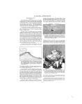
ARCHAEOLOGICAL FEATURES OF THE COUNTIES district, was depopulated by smallpox, according to the story of Mackawdebenessy, or "Blackbird," a continuous village some fifteen or sixteen miles long extended from what is now Cross Village to Seven Mile Point. "The trees were entirely cut away from this long village," a veritable Alba Longa. This may have been the place referred to by Father Dablon, who said in the Relation of 1670-72, describing the mission of Outaouaces: "Some of them still living declare that they constituted thirty villages, and that they had entrenched themselves in a fort a league and a half in circumference." Leach says that the Mascoutens had villages at Seven Mile Point and Harbor Springs. Much of the subsistence for this unusual population was derived from the lake, which afforded abundance of fish during the season, and corn was so extensively cultivated that the garrisons in later times at Fort Mackinac depended upon the Ottawas from L'Arbre Croche for this commodity. Cross Village and Good Heart are still occupied by numerous Ottawa families. Old villages were probably deserted for the winter, after the corn was harvested and cached, for the hunting grounds upon the inland streams and the sugar making of early spring. There was a trail upon the bluff following the lake shore. See notes on Mecosta County. SITES IDENTIFIED Villages ---------- 9 Burying grounds -- 5 Mounds -----------2 termines population. The rural white population of the county is today only sixteen per square mile. At Edenville, Midland County, at the coming together of the Tobacco and Tittabawassee rivers, the main trail through the central part of the state branched. One branch passed through Tobacco, Buckeye, Sage, and Sherman townships, and went on to the Grand Traverse region. The other trail passed through Billings, Hay, Secord, and Clement townships and led to Cheboygan. This latter trail, as the broken lines upon the map indicate, cannot be traced as accurately as the Grand Traverse path. TOWNSHIPS 1. Sherman 9. 2. Butman 10. 3. Clement 11. 4. Bourrett 12. 5. Sage 13. 6. Gladwin 14. 7. Secord 15. 8. Sheridan Grout Buckeye Hay Beaverton Tobacco Billings Bentley 1. 2. 3. 4. 5. 6. 7. 8. To Wawatam Bliss Carp Lake Cross Village Readmond Center McKinley Friendship WNSHIP 9. 10. 11. 12. 13. 14. 15. 16. s Pleasant View Maple River West Traverse Little Traverse Little Field Resort Bear Creek Springvale GENESEE COUNTY (Map 9) Like the other counties of the Saginaw valley, Genesee was well adapted to Indian life. The Flint River and the adjacent lands were favorite rendezvous. There was a group of eight mounds upon the river bank in the southern part of the corporation limits of the city of Flint. Another group of twenty was situated upon the west bank of the Flint, a mile above Flushing. The trail from Detroit to Saginaw cut the county diagonally from southeast to northwest, and a branch trail led from the Flint Reservation west to Shiawassee Town. Montrose Township contained a number of mounds and two villages; it was the southern limit of a region thickly dotted with sites extending into Taymouth Township, Saginaw County. SITES IDENTIFIED Villages -----------7 Burying grounds -_ 2 Mounds ----------48 GOGEBIC COUNTY (Map 15) Unusual and varied earth constructions stood at one time upon an island in Lac Vieux Desert, through which passes the boundary line between Michigan and Wisconsin. Figure 6, which is taken from Schoolcraft, enables one to visualize... the situation better 7/^ ^'/ than words can de-:. scribe i t. Mounds,, /%:-l.., embankments, in- t! ODWELL *6 closures, "deep exca-,,,", "...t. vations," and a large 'SF VI LAGE village at one time oc- j. "s--(%IS8O 1 NO cupied the island. It.. | q1,m. 't pM has been mentioned in i - the notes upon Me- <f MOUN N,, nominee County that:-., O3 135 Its. t h e mound-building. z. '.O..NDt ^ culture of Wisconson i> encroached slI i g h t I y upon what is now,DEEP EXGAVAT!ONS M i c h i g a n territory. The situation at Lac Vieux Desert is another illustration of this. A village stood at the mouth of Mon- FIG. 6. Diagram of earthworks on an island attrea Ri anda- in Lac Vieux Desert, Schoolcraft, Indian treal River and an- Tribes of the United States, 1847, Part II other at Little Girl's Point. A mound is situated at the mouth of Trout Creek, east side of Lake Gogebic. The surveyors' notes occasionally mention crossing old trails, but they are too fragmentary to justify attempts at retracings. A trail connected Lake Gogebic with the headwaters of the Wisconsin River. SITES IDENTIFIED Villages------- 3 Mounds --------4 Inclosure ------- 1 Embankment 2 1. 2. 3. 4. 5. 6. 7. 8. 9. TOWNSHIPS Montrose 10. Flint Vienna 11. Burton Thetford 12. Davison Forest 13. Gaines Flushing 14. Mundy Mt. Morris 15. Grand Blanc Genesee 16. Atlas Richfield 17. Argentine Clayton 18. Fenton TOWNSHIPS 1. Ironwood 5. Marenisco 2. Wakefield 6. Watersmeet 3. Erwin 7. Carlson 4. Bessemer GLADWIN COUNTY (Map 12) Gladwin County does not seem to have been conducive to permanent Indian occupancy; at least nothing has been reported to, or discovered by, the Museum staff to warrant mapping any sites. It must always be kept in mind that the means of subsistence de GRAND TRAVERSE COUNTY (Map 11) Within or very near the present limits of Traverse City there were seven isolated mounds, a group of three upon Boardman Lake, a group the number of which is undetermined, a village, and -20 -
-
Scan 1

Page #1 - Front Matter
-
Scan 2

Page #2 - Front Matter
-
Scan 3

Page #3 - Title Page
-
Scan 4

Page #4
-
Scan 5
Page #5 - Table of Contents
-
Scan 6
Page #6 - List of Illustrations
-
Scan 7

Page #7 - Comprehensive Index
-
Scan 8

Page #8
-
Scan 9

Page 1
-
Scan 10

Page 2
-
Scan 11

Page 3
-
Scan 12

Page 4
-
Scan 13

Page 5
-
Scan 14

Page 6
-
Scan 15

Page 7
-
Scan 16

Page 8
-
Scan 17

Page 9
-
Scan 18

Page 10
-
Scan 19

Page 11
-
Scan 20

Page 12
-
Scan 21

Page 13
-
Scan 22

Page 14
-
Scan 23

Page 15
-
Scan 24

Page 16
-
Scan 25

Page 17
-
Scan 26

Page 18
-
Scan 27

Page 19
-
Scan 28

Page 20
-
Scan 29

Page 21
-
Scan 30

Page 22
-
Scan 31

Page 23
-
Scan 32

Page 24
-
Scan 33
Page 25
-
Scan 34

Page 26
-
Scan 35

Page 27
-
Scan 36

Page 28
-
Scan 37

Page 29
-
Scan 38

Page 30
-
Scan 39
Page 31
-
Scan 40

Page 32
-
Scan 41

Page 33
-
Scan 42

Page 34
-
Scan 43

Page 35
-
Scan 44

Page 36
-
Scan 45

Page 37
-
Scan 46

Page 38
-
Scan 47

Page #47
-
Scan 48

Page #48
-
Scan 49

Page #49
-
Scan 50

Page #50
-
Scan 51

Page #51
-
Scan 52

Page #52
-
Scan 53

Page #53
-
Scan 54

Page #54
-
Scan 55

Page #55
-
Scan 56

Page #56
-
Scan 57

Page #57
-
Scan 58

Page #58
-
Scan 59

Page #59
-
Scan 60

Page #60
-
Scan 61

Page #61
-
Scan 62

Page #62
-
Scan 63

Page #63
-
Scan 64

Page #64
-
Scan 65

Page #65
-
Scan 66

Page #66
-
Scan 67

Page #67
-
Scan 68

Page #68
-
Scan 69

Page #69
-
Scan 70

Page #70
-
Scan 71

Page #71
-
Scan 72

Page #72
-
Scan 73

Page #73
-
Scan 74

Page #74
-
Scan 75

Page #75
-
Scan 76

Page #76
-
Scan 77

Page #77
-
Scan 78

Page #78
-
Scan 79

Page #79
-
Scan 80

Page #80
-
Scan 81

Page #81
-
Scan 82

Page #82
-
Scan 83

Page #83
-
Scan 84

Page #84
-
Scan 85

Page #85
-
Scan 86

Page #86
-
Scan 87

Page #87
-
Scan 88

Page #88
-
Scan 89

Page #89
-
Scan 90

Page #90
-
Scan 91

Page #91
-
Scan 92

Page #92
-
Scan 93

Page #93
-
Scan 94

Page #94
About this Item
- Title
- Archaeological atlas of Michigan [by] Wilbert B. Hinsdale...
- Author
- Hinsdale, W. B. (Wilbert B.), 1851-1944.
- Canvas
- Page 20
- Publication
- Ann Arbor,: University of Michigan press,
- 1931.
- Subject terms
- Indians of North America -- Michigan
- Names, Geographical -- Michigan.
- Michigan -- Antiquities
- Michigan -- Description and travel
Technical Details
- Collection
- Digital General Collection
- Link to this Item
-
https://name.umdl.umich.edu/1265156.0001.001
- Link to this scan
-
https://quod.lib.umich.edu/g/genpub/1265156.0001.001/28
Rights and Permissions
Where applicable, subject to copyright. Other restrictions on distribution may apply. Please go to http://www.umdl.umich.edu/ for more information.
Related Links
IIIF
- Manifest
-
https://quod.lib.umich.edu/cgi/t/text/api/manifest/genpub:1265156.0001.001
Cite this Item
- Full citation
-
"Archaeological atlas of Michigan [by] Wilbert B. Hinsdale..." In the digital collection Digital General Collection. https://name.umdl.umich.edu/1265156.0001.001. University of Michigan Library Digital Collections. Accessed June 12, 2025.