Archaeological atlas of Michigan [by] Wilbert B. Hinsdale...
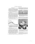
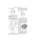
ARCHAEOLOGICAL FEATURES OF THE COUNTIES often disturbed Lake Superior, and their waters, when not frozen, afforded abundance of food. Missions would not have been located upon Keweenaw Bay at an early day if there had not been Indians for them to serve. Almost directly across the bay from the Catholic mission, north of Baraga, a Methodist mission was established north of L'Anse. Each of these posts is at this time surrounded by numerous Indian families. The Marquette trail came to the head of Keweenaw Bay by way of Lake Michigamme. An important trail route toward the Wisconsin country went to and beyond Lac Vieux Desert upon the state line in the southeast corner of Gogebic County. The Marquette trail branched at the west end of Lake Michigamme; the branch turning north terminated at Skanee, where an Indian village must have stood at one time. The trail that led from the head of Keweenaw Bay to the mouth of Misery River, Ontonagon County, was really a continuation of the Marquette trail. As the map indicates, several short trails led back from the bay. SITES IDENTIFIED Villages ---------- 5 Burying groundI 1 BAY COUNTY (Map 9) Within the limits of Bay City and Essexville, which immediately join it, eight mound sites, two village sites, and three buryings have been located. A glance at the map will instantly show numerous village sites upon or near the Kawkawlin River. It is worth noting that Mr. Bela Hubbard, writing in 1886, observed that at the mouth of the Kawkawlin River, upon a swelling knoll overlooking the bay, in the midst of a tract of country from which all timber had been burned, was a spot which seemed to have been dedicated to the "evil Manitou." "Here an altar was erected of two large stones several feet high, with a flat top and broad base. About were smaller stones which were covered with propitiatory offerings: bits of tobacco, pieces of tin and flints." Sites are numerous along the trail which followed the Saginaw Bay Shore. Mr. W. L. Schmidt of Pinconning has surveyed the county quite thoroughly for the Museum. Dr. F. M. Vreeland, of De Pauw University, has also been over the counties contiguous to the bay, as a Museum field representative. SITES IDENTIFIED Villages -----------21 Burying grounds - - 8 Mounds ----------11 1. 2. 3. TOWNSHIPS Baraga 4. Covington Arvon 5. Spur L'Anse BARRY COUNTY (Map 5) The topography of Barry County leads one to infer that it was much more thickly inhabited than the map indicates. The many -----------------lakes and the Thornapple River Valley are parts of an environment which was inSlviting. The old village in Section 28, I*<'A - ) / Thornapple Townl^ - ( S h ship, was the crossing, point of a number of S. O trails. See Figure 5. Mr. Charles A. Weissert of Kalama/. o, ~ ' zoo states that oldlIn'..... /' Kt.f.. - dian cornfields were .:zstill visible along the SLThornapple when the land was first "taken " -oi Couty.!up. He also refers ht-,ito a trail that led from lag the villages in Hasox, tings Township upon or near Thornapple. T4;- ' Kk! 'y ~~/)4/$( Lake, onehof which S",was called Indian nLanding, to MeshimM dmeneconing's village FIG. 5. Old Indian trail parts of which may on the Grand River, still be traced upon the west side of D a n b y Township, Thornapple Lake Ionia County. SITES IDENTIFIED Villages-----------9 Burying grounds-__ 9 Mounds-----------4 1. 2. 3. 4. 5. 6. 7. Gibson Mt. For Pincomn Garfieli Fraser Beaver Kawkai TOWNSHIPS 8. 'est 9. ning 10. d 11. 12. 13. wlin 14. Williams Monitor Bangor Hampton Frankenlust Portsmouth Merritt BENZIE COUNTY (Map 11) There are legends and mythical lore connected with Crystal Lake and Betsey River, but not many facts for the archaeological cartographer. The topography of the county suggests that a survey would have been rewarded by more of a tangible nature than has been discovered or reported. An Indian burying ground and mound were located near Honor. A mound stood near the center of Inland Township and a village upon the north side of the west end of Crystal Lake. SITES IDENTIFIED Village ------------ 1 Burying ground --- 1 Mounds -----------2 TOWNSHIPS 1. 2. 3. 4. 5. 6. Lake Platte Almira Crystal Lake Benzonia Homestead 7. 8. 9. 10. 11. 12. Inland Gilmore Blaine Joyfield Weldon Colf ax 1. 2. 3. 4. 5. 6. 7. 8. TOWNSHIPS Thornapple 9. Irving 10. Carlton 11. Woodland 12. Yankee Springs 13. Rutland 14. Hastings 15. Castleton 16. Orangeville Hope Baltimore Maple Grove Prairieville Barry Johnstown Assyria BERRIEN COUNTY (Map 4) Living conditions upon the St. Joseph River were excellent in Indian times, as well as now. The centers of greatest activity in Berrien County appear to have been along the river in Buchanan and Niles townships. According to the evidence so far obtained, no counties in the state, except Saginaw and Newaygo, had so many villages. Village sites have been found in such close proximity that the letter N, denoting "indefinite number," is used in connection with a group upon Galien River, just north of New Troy, Weesaw Township. There was another village group three miles north of the New Troy settlements, in Lake Township. Villages in close proximity indicate that people of different tribes, or sub -16 -
-
Scan 1

Page #1 - Front Matter
-
Scan 2

Page #2 - Front Matter
-
Scan 3

Page #3 - Title Page
-
Scan 4

Page #4
-
Scan 5
Page #5 - Table of Contents
-
Scan 6
Page #6 - List of Illustrations
-
Scan 7

Page #7 - Comprehensive Index
-
Scan 8

Page #8
-
Scan 9

Page 1
-
Scan 10

Page 2
-
Scan 11

Page 3
-
Scan 12

Page 4
-
Scan 13

Page 5
-
Scan 14

Page 6
-
Scan 15

Page 7
-
Scan 16

Page 8
-
Scan 17

Page 9
-
Scan 18

Page 10
-
Scan 19

Page 11
-
Scan 20

Page 12
-
Scan 21

Page 13
-
Scan 22

Page 14
-
Scan 23

Page 15
-
Scan 24

Page 16
-
Scan 25

Page 17
-
Scan 26

Page 18
-
Scan 27

Page 19
-
Scan 28

Page 20
-
Scan 29

Page 21
-
Scan 30

Page 22
-
Scan 31

Page 23
-
Scan 32

Page 24
-
Scan 33
Page 25
-
Scan 34

Page 26
-
Scan 35

Page 27
-
Scan 36

Page 28
-
Scan 37

Page 29
-
Scan 38

Page 30
-
Scan 39
Page 31
-
Scan 40

Page 32
-
Scan 41

Page 33
-
Scan 42

Page 34
-
Scan 43

Page 35
-
Scan 44

Page 36
-
Scan 45

Page 37
-
Scan 46

Page 38
-
Scan 47

Page #47
-
Scan 48

Page #48
-
Scan 49

Page #49
-
Scan 50

Page #50
-
Scan 51

Page #51
-
Scan 52

Page #52
-
Scan 53

Page #53
-
Scan 54

Page #54
-
Scan 55

Page #55
-
Scan 56

Page #56
-
Scan 57

Page #57
-
Scan 58

Page #58
-
Scan 59

Page #59
-
Scan 60

Page #60
-
Scan 61

Page #61
-
Scan 62

Page #62
-
Scan 63

Page #63
-
Scan 64

Page #64
-
Scan 65

Page #65
-
Scan 66

Page #66
-
Scan 67

Page #67
-
Scan 68

Page #68
-
Scan 69

Page #69
-
Scan 70

Page #70
-
Scan 71

Page #71
-
Scan 72

Page #72
-
Scan 73

Page #73
-
Scan 74

Page #74
-
Scan 75

Page #75
-
Scan 76

Page #76
-
Scan 77

Page #77
-
Scan 78

Page #78
-
Scan 79

Page #79
-
Scan 80

Page #80
-
Scan 81

Page #81
-
Scan 82

Page #82
-
Scan 83

Page #83
-
Scan 84

Page #84
-
Scan 85

Page #85
-
Scan 86

Page #86
-
Scan 87

Page #87
-
Scan 88

Page #88
-
Scan 89

Page #89
-
Scan 90

Page #90
-
Scan 91

Page #91
-
Scan 92

Page #92
-
Scan 93

Page #93
-
Scan 94

Page #94
About this Item
- Title
- Archaeological atlas of Michigan [by] Wilbert B. Hinsdale...
- Author
- Hinsdale, W. B. (Wilbert B.), 1851-1944.
- Publication
- Ann Arbor,: University of Michigan press,
- 1931.
- Subject terms
- Indians of North America -- Michigan
- Names, Geographical -- Michigan.
- Michigan -- Antiquities
- Michigan -- Description and travel
Technical Details
- Collection
- Digital General Collection
- Link to this Item
-
https://name.umdl.umich.edu/1265156.0001.001
- Link to this scan
-
https://quod.lib.umich.edu/g/genpub/1265156.0001.001/24
Rights and Permissions
Where applicable, subject to copyright. Other restrictions on distribution may apply. Please go to http://www.umdl.umich.edu/ for more information.
Related Links
IIIF
- Manifest
-
https://quod.lib.umich.edu/cgi/t/text/api/manifest/genpub:1265156.0001.001
Cite this Item
- Full citation
-
"Archaeological atlas of Michigan [by] Wilbert B. Hinsdale..." In the digital collection Digital General Collection. https://name.umdl.umich.edu/1265156.0001.001. University of Michigan Library Digital Collections. Accessed May 21, 2025.