Archaeological atlas of Michigan [by] Wilbert B. Hinsdale...
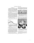
ALCONA-BARAGA The territory was crossed by numerous trails. Fuller, in his Economic Beginnings of Michigan, speaks of important trails meeting and crossing where the city of Allegan now stands, but his citations do not justify placing the trails upon the map, because their courses through the county are vaguely described. Even the field notes of the government surveyors in 1831 and 1837 fail to mention all the trail crossings. Attention has been called (p. 6) to the Kalamazoo River, which passes through the county diagonally from southeast to northwest, as a waterway of great importance in Indian travel. SITES IDENTIFIED Villages -------------11 Burying grounds -----4 Mounds-----------14 Circular inclosures _ 7 TOWNSHIPS 1 1 1 1. Laketown 13. Ganges 2. Fillmore 14. Clyde 3. Overisel 15. Valley 4. Salem 16. Allegan 5. Dorr 17. Watson 6. Leighton 18. Martin 7. Saugatuck 19. Casco 8. Manlius 20. Lee 9. Heath 21. Cheshire [0. Monterey 22. Trowbridge 1i. Hopkins 23. Otsego 12. Wayland 24. Gun Plains usual archaeological interest. There are a few mutilated mounds still standing upon the west side of Devil Lake. According to the report of Mr. Gillman just cited, a trephined skull (Figure 4) was taken from one of the mounds at Devil River by the Rev. Dr. Pilcher. The hole in the vertex is very symmetrical and was bored while the person was still living. So far as known, this is the farthest north that any trephined skull has been found. The Thunder Bay Islands have considerable mythology connected with them. Three villages have been definitely located in the county: one upon what was formerly Flat Rock Point, now called North Point; one at the mouth of Devil River; and one at Alpena. There were, of course, many other sites, but the facts at hand do not warrant putting them upon the map. The Museum staff has made a quite thorough survey of this interesting county with the foregoing items to record. An unusual number of copper implements has been collected upon the village site in the northwest part of the city of Alpena by Mr. Gerald Haltiner. SITES IDENTIFIED Villages ---------3 Burying grounds- 2 Mounds --------14 TOWNSHIPS 1. Wellington 5. Green 2. Long Rapids 6. Wilson 3. Maple Ridge 7. Ossineke 4. Alpena 8. Sanborn ANTRIM COUNTY (Map 13) Sites are numerous in the lake district of the southwestern part of the county. There was a circular inclosure at Elk Rapids and one upon each side of Torch Lake. Several mound, village, and burial sites have been located, but none very far from bodies of water. SITES IDENTIFIED Villages -----------7 Burying grounds ----- 3 Mounds -----------14 Circular inclosures __ 3 TOWNSHIPS ALPENA COUNTY (Map 14) Cyrus Thomas, Catalogue of Prehistoric Works East of the Rocky Mountains (1891), quotes Mr. Gerard Fowke as saying: "There were long, flat, circular mounds on almost every section along the east side of Devil's Lake and along Thunder Bay River for 10 miles from its mouth." Mr. Henry Gillman, Smithsonian 1. 2. 3. 4. 5. 6. 7. 8. Banks Central Lake Echo Jordan Warner Torch Lake Forest Home Kearney 9. 10. 11. 12. 13. 14. 15. Chestonia Star Elk Rapids Milton Helena Custer Mancelona ARENAC COUNTY (Map 12) Along or in the vicinity of the Bay shore there were a few settlements. It is not impossible that the fort-builders, who were very active in Ogemaw County, also had sites upon the Rifle River toward its mouth, but no evidences of them have been found. SITES IDENTIFIED Villages ----------- 5 Burying grounds -- 7 Mounds -----------2 TOWNSHIPS 1. Moffitt 7. Deep River 2. Clayton 8. Arenac 3. Mason 9. Au Gres 4. Turner 10. Sims 5. Whitney 11. Lincoln 6. Adams 12. Standish BARAGA COUNTY (Map 16) The indentations made by two deep bays give Baraga County an unusual length of shore line. The inlets and coves sheltered the fishermen from the turbulence of the waves and storms that FIG. 4. Trephined skull from Devil River mound, Alpena County Report (1875), also reports explorations of mounds below the mouth of Devil River. It is possible at this time to locate correctly but very few of these sites. Along the Huron shore, from two miles below Ossineke to Alpena and from there up the Thunder Bay River to Long Rapids, there are unmistakable proofs of a numerous population of Indian fisher folk who built mounds some of which were of un -15 -
-
Scan 1

Page #1 - Front Matter
-
Scan 2

Page #2 - Front Matter
-
Scan 3

Page #3 - Title Page
-
Scan 4

Page #4
-
Scan 5
Page #5 - Table of Contents
-
Scan 6
Page #6 - List of Illustrations
-
Scan 7

Page #7 - Comprehensive Index
-
Scan 8

Page #8
-
Scan 9

Page 1
-
Scan 10

Page 2
-
Scan 11

Page 3
-
Scan 12

Page 4
-
Scan 13

Page 5
-
Scan 14

Page 6
-
Scan 15

Page 7
-
Scan 16

Page 8
-
Scan 17

Page 9
-
Scan 18

Page 10
-
Scan 19

Page 11
-
Scan 20

Page 12
-
Scan 21

Page 13
-
Scan 22

Page 14
-
Scan 23

Page 15
-
Scan 24

Page 16
-
Scan 25

Page 17
-
Scan 26

Page 18
-
Scan 27

Page 19
-
Scan 28

Page 20
-
Scan 29

Page 21
-
Scan 30

Page 22
-
Scan 31

Page 23
-
Scan 32

Page 24
-
Scan 33
Page 25
-
Scan 34

Page 26
-
Scan 35

Page 27
-
Scan 36

Page 28
-
Scan 37

Page 29
-
Scan 38

Page 30
-
Scan 39
Page 31
-
Scan 40

Page 32
-
Scan 41

Page 33
-
Scan 42

Page 34
-
Scan 43

Page 35
-
Scan 44

Page 36
-
Scan 45

Page 37
-
Scan 46

Page 38
-
Scan 47

Page #47
-
Scan 48

Page #48
-
Scan 49

Page #49
-
Scan 50

Page #50
-
Scan 51

Page #51
-
Scan 52

Page #52
-
Scan 53

Page #53
-
Scan 54

Page #54
-
Scan 55

Page #55
-
Scan 56

Page #56
-
Scan 57

Page #57
-
Scan 58

Page #58
-
Scan 59

Page #59
-
Scan 60

Page #60
-
Scan 61

Page #61
-
Scan 62

Page #62
-
Scan 63

Page #63
-
Scan 64

Page #64
-
Scan 65

Page #65
-
Scan 66

Page #66
-
Scan 67

Page #67
-
Scan 68

Page #68
-
Scan 69

Page #69
-
Scan 70

Page #70
-
Scan 71

Page #71
-
Scan 72

Page #72
-
Scan 73

Page #73
-
Scan 74

Page #74
-
Scan 75

Page #75
-
Scan 76

Page #76
-
Scan 77

Page #77
-
Scan 78

Page #78
-
Scan 79

Page #79
-
Scan 80

Page #80
-
Scan 81

Page #81
-
Scan 82

Page #82
-
Scan 83

Page #83
-
Scan 84

Page #84
-
Scan 85

Page #85
-
Scan 86

Page #86
-
Scan 87

Page #87
-
Scan 88

Page #88
-
Scan 89

Page #89
-
Scan 90

Page #90
-
Scan 91

Page #91
-
Scan 92

Page #92
-
Scan 93

Page #93
-
Scan 94

Page #94
About this Item
- Title
- Archaeological atlas of Michigan [by] Wilbert B. Hinsdale...
- Author
- Hinsdale, W. B. (Wilbert B.), 1851-1944.
- Publication
- Ann Arbor,: University of Michigan press,
- 1931.
- Subject terms
- Indians of North America -- Michigan
- Names, Geographical -- Michigan.
- Michigan -- Antiquities
- Michigan -- Description and travel
Technical Details
- Collection
- Digital General Collection
- Link to this Item
-
https://name.umdl.umich.edu/1265156.0001.001
- Link to this scan
-
https://quod.lib.umich.edu/g/genpub/1265156.0001.001/23
Rights and Permissions
Where applicable, subject to copyright. Other restrictions on distribution may apply. Please go to http://www.umdl.umich.edu/ for more information.
Related Links
IIIF
- Manifest
-
https://quod.lib.umich.edu/cgi/t/text/api/manifest/genpub:1265156.0001.001
Cite this Item
- Full citation
-
"Archaeological atlas of Michigan [by] Wilbert B. Hinsdale..." In the digital collection Digital General Collection. https://name.umdl.umich.edu/1265156.0001.001. University of Michigan Library Digital Collections. Accessed May 13, 2025.