- Volume 45 | Permalink
- Print article
- Download PDF 1.7mb
Geography, History, and Routes of Travel
Today, Kadwāhā is a relatively remote village of approximately eight hundred households and 4,500 people.[10] Nonetheless, it remains the nexus of the surrounding area: the modern Bījāsan Devī temple attracts crowds of villagers and merchants to Kadwāhā to worship and exchange goods at a biweekly festival.[11] Close by is a gaḍhī (fort) that contains the remains of the earlier maṭha (monastery), its temple, and the mosque that was built when the fortress was converted into a ribāṭ. The gaḍhī and the monuments that preceded and followed it form the heart of Kadwāhā’s current residential core, whose much earlier roots are still visible through fragments of medieval town walls.[12] As the oldest structure within the village center, the maṭha seems to have been the stimulus for the larger settlement, whose boundaries are marked by the circular distribution of Kadwāhā’s temples to the north, east, and west (fig. 4).
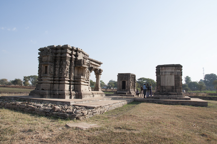
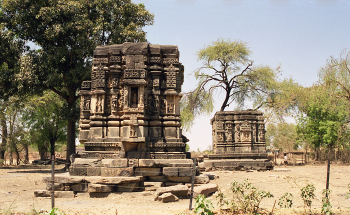
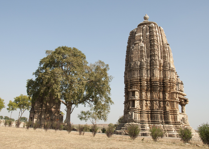
The remaining fourteen temples within Kadwāhā proper are clustered in distinct groups that radiate around the monastery and frame the outskirts of the village. The earliest of these, the late ninth-century Caṇḍāla Maṭh, is situated to the northwest (fig. 5). Just west of the monastery and the gaḍhī are four temples: the solitary Eklāvālā temple and the three temples of the Akhatiavāla group (figs. 6–7). Five more temples—including one known today as the Mārgatvāla temple, and four more set off in pairs that form the Nahalvār and Khirnīvālā groups—can be found to the north (fig. 8). And finally to the east are two more pairs of temples, constituting the Pachalīvālā and Morāyat groups, the latter of which contains the grand Toteśvara Mahādeva, perhaps the best known of Kadwāhā’s shrines (fig. 9). With the exception of the Caṇḍāla Maṭh and the eleventh-century Toteśvara Mahādeva and Mārgatvāla, Kadwāhā’s temples generally can be dated to the tenth century on the basis of style.[13] The maṭha itself most likely dates to the ninth or tenth century and the accompanying temple to the first half of the tenth. The centrality of the maṭha and its temple is emphasized through two factors. The first is their later incorporation into a thirteenth-century fortress built as a response to Sultanate-era incursions in the area under the Khaljis (circa 1290–1316).[14] The second can be seen in the distribution and affiliations of the surviving temples throughout the village; while ten are either Śaiva or Śaiva-śakta, only five are Vaiṣṇava.


Historically, Kadwāhā and its broader subregion were fairly remote, situated within what R. N. Misra has described as the geography of the wilderness (āraṇya) beyond the domain of established villages (grāma) and earlier historical states (janapadas). The area may have been populated by a range of itinerant communities, including autonomous tribal groups (āṭavikas), ascetics, and merchants.[15] Nonetheless, it was central in its own way. Situated in the southernmost part of the ancient region of Gopakṣetra, it sat between at least three other regions—Jejākabhukti (Bundelkhand) to the east, Dāśārṇa to the south, and Mālavā to the west (fig. 10).[16] More specifically, it developed along an area sometimes referred to as the Mahuār River region, which formed between the branching ends of two local rivers, the Madhumatī (Mahuār) and Ahīrāvati, which found their source eighty to ninety kilometers north in the Sindhu River.
The Madhumatī and Ahīrāvati Rivers, although never major waterways, were advantageous because of their geographical relationship to the Betwā River, which ran roughly parallel to the Sindhu in a winding journey along the Yamunā basin.[17] Along the way, each river passed important regional centers—Vidiśa in the case of the Betwā, and Gwalior and Padmāvatī (modern Pawāyā) in the case of the Sindhu. Flowing steeply southward, the Mahuār and Ahīrāvati were ideally situated to facilitate the development of settlements between the Betwā and the Sindhu. Thus, travelers seeking passage to Gwalior from Vidiśa, Devgaḍh (Deogarh), or any number of important places located along the Betwā River, may have found sites such as Kadwāhā to be ideal points of transition from which they could then continue their journey to the next key junction.[18] Kadwāhā may have grown in importance because of its proximity to a westward bend in the Betwā River that marked a transition to the tributaries of the Sindhu. Near the confluence of the Mahuār and Sindhu Rivers was Padmāvatī, an old urban center that had flourished under the Nāga kings who had ruled areas of central India prior to their conquest by the imperial Guptas in the fifth century.[19]
During the seventh and eighth centuries, the areas around Kadwāhā became integrated, to varying degrees, into the administration of the various rulers of Kannauj (Kānyakubja), situated in the Gaṅgā-Yamunā Doab to the north, and Ujjain, in Mālavā, to the west. That the long-distance connection with imperial Kānyakubja stems back at least to the seventh century is attested through an inscription describing the construction of a Śiva temple at Mahuā by a local king named Vatsarāja.[20] While Vatsarāja may have hailed from somewhere near Ujjain, the poet who composed the inscription is believed to have had some connection with the imperial center. In the inscription, he is described as Bhaṭṭa Īśāna, son of Bhaṭṭa Somāṅka and younger brother of Bhaṭṭa Devasvāmin, who hailed from Kānyakubja.[21] Evidence from Padmāvatī, further to the north, reveals continuing transregional connections, moving north to south, from the Deccan to Kānyakubja, as seen through the movements of the eighth-century court poet, Bhavabhūti. Originally from Vidarbha, a city that once stood less than fifty miles from modern Nagpur in Maharashtra, Bhavabhūti lived in Padmāvatī for a time before taking up a post at the court of the imperial monarch Yaśovarman of Kānyakubja (Kanauj) (circa 720–50 CE).[22] Bhavabhūti himself likely passed through the Mahuār River region on the way to Padmāvatī, mirroring the imagined journey of a yoginī named Saudāminī, which he evoked beautifully in his renowned drama, the Mālatī-Mādhava.[23]
In the early ninth century, Kānyakubja was captured and occupied by the imperial Gurjara Pratīhāras, who remained the dominant power in northern and central India through the middle of the tenth century. In the areas around the Mahuār (Madhumatī) and Ahīrāvati Rivers, the Pratīhāra presence was loosely felt due to the actions of their local feudatory lords (mahāsāmantādhipatis), who operated under the jurisdiction of the Gurjara Pratīhāras’ agents in Gwalior. These connections can be seen particularly in a memorial pillar inscription from Terāhī, a site less than ten miles northeast of Kadwāhā, dated to VS 962 (905 CE), commissioned upon the death of a chief named Allabhaṭṭa during a battle against the Karṇāṭas or the Rāṣṭrakūtas of Maharashtra.[24] Although Allabhaṭṭa’s identity remains a matter of conjecture, R. N. Misra has previously suggested that he hailed from Gwalior and may have been an individual named Alla, son of Vāillabhaṭṭa. Alla was appointed as the guardian of the fortress at Gwalior and served as the “chief of the boundaries” (maryādādhurya) under the Gurjara Pratīhāra king Bhojadeva.[25] It may be that the recorded battle was related to the successful military campaign of the Gurjara Pratīhāra king Mahendrapāla (reigned 885–910) along the Gulf of Cambay in Gujarat.
Although connected across wide geographies, the long distance even from Gwalior may have lent local lords a greater degree of autonomy than was the case in places closer to the administrative center, as is suggested in two more memorial pillar inscriptions, also from Terāhī. Dated just two years earlier, to VS 960 (903 CE), these inscriptions record warriors who fell in what appears to have been a local battle, perhaps over territory, between two mahāsāmantādhipatis named Guṇarāja and Undabhaṭṭa on July 16 of that year.[26] Ongoing conflicts with the Rāṣṭrakūtas over Madhyadeśa may have hastened the transformation of feudatory chiefs into significant and autonomous local royal rulers. During the transition, Undabhaṭṭa’s family took on a new level of authority from their capital at Buḍhi Chanderī. This process, which can be traced through inscriptional records of the tenth and early eleventh centuries, is attested with particular clarity in an extended inscription from the site of Siyaḍoṇī (modern Sīron Khurd).[27] Undabhaṭṭa is listed as one of a number of individuals who provided endowments for daily payment to the local Viṣṇu temple during VS 964 (907–8 CE), just a few years later than the record from Terāhī, which was located only twenty-seven miles away. He is described by the titles mahāsāmantādhipati, mahāprātihāra (superintendent or guard of a capital city), and samadhigatāśeṣamahāśabda (feudatory). But because the inscription from Siyaḍoṇī contains an extensive record of numerous deeds covering a sixty-five-year period, from VS 960 to VS 1025 (903–4 to 968–69 CE), it reveals a longer history through which Undabhaṭṭa’s successors claimed increasing power by utilizing more prestigious imperial titles. By the end of the tenth century, the king Harirāja had fully transitioned from mahāsāmantādhipati to mahārājādhirāja and nr̥pacakravarttī, or “emperor among kings.”[28]
This transformation from local feudatory chief to autonomous royal ruler culminated in a fragmentary inscription found in the remains of the maṭha in the center of the gaḍhi at Kadwāhā.[29] According to the inscription, King Harirāja traveled to Kadwāhā seeking dīkśa (initiation) from the Śaiva sage presiding over the maṭha. Before the guru performed the ritual, he asked the head attendant, “Who is this long-lived king [nr̥pa]?” The attendant replied by identifying Harirāja as a member of “a gotra of the Pratīhāra kings [mahīśvara],” which stemmed from a ruler named Durbhaṭa “... whose lotus feet were attached to the circle of the crest jewels of ... [the] fierce cloud of the roaring Gūrjjaras....”[30] This reference is quite telling, as his predecessor Undabhaṭṭa functioned as the mahāsāmantādhipati of the imperial Gurjara Pratīhāras, who are referred to by the title parameśvara (supreme lord) in the Siyaḍoṇī inscription.[31] The ascendency of this local family, from mahāsāmantādhipati to parameśvara, belies the predominant scholarly belief that Kadwāhā and other sites in its vicinity fell under the suzerainty of the Kacchapaghātas, who ruled further north at Gwalior and Sihoniyā during the tenth and eleventh centuries and are notably absent from the inscriptional record. By contrast, at least five fragmentary inscriptions related to the Pratīhāras of Buḍhi Chanderī were found at Kadwāhā,.[32]
The shifting nature of politics left their mark more clearly in the architectural than in the inscriptional record. During the seventh, eighth, and ninth centuries, the Mahuār River region gave rise to a number of new settlements, recognizable through the presence of intact stone temples and monasteries in the modern villages of Mahuā, Indor, Sakarra, Ranod, Terāhī, Surwāyā, and Baktar (figs. 11–12).[33] In addition to marking the development of new settlements, these temples also suggest a new degree of permanence, not merely of local agrarian communities but of religious groups that may have been more frequently itinerant in earlier periods. While the buildup of new monuments occurred slowly during the seventh through ninth centuries, the tenth and eleventh centuries witnessed more rapid developments, most visible through the expansion of earlier monasteries and the rise of new temple towns, such as Kadwāhā and Thubon. Such architectural activity, particularly in the long-lasting medium of stone, is fairly significant in relationship to this larger history as it indexed both an influx of wealth and an investment in the local region. For example, the expansion of architectural activities at Kadwāhā was likely linked, in part, to the attention of the newly formed Pratīhāras of Buḍhi Chanderī, the descendants of Undabhaṭṭa, who had served as the mahāsāmantādhipatis under the Gwalior-based agents of the imperial Gurjara Pratīhāras.[34]
At the same time, Kadwāhā cannot be fully understood through the rubric of royalty. At larger centers, such as Khajurāho, the sponsorship of temples was connected to the imperial aspirations of their patrons. Accordingly, one finds a regulated homology of ornamentation, style, and form—as well as a grandeur of scale—that expresses architecture’s potential to articulate power and political authority. In contrast, the temples at Kadwāhā were a truly motley crew. Instead of homology, we encounter a diversity of scale, architectural form, and ornamentation.[35] Rather than signaling a conscious imperial program, we see instead multiple creative and dynamic engagements with architectural ideas and building practices circulating on wider regional and transregional levels. In short, the diversity of the architectural styles and forms points less to the model of a royal center than to the eclecticism of growing new communities settling not at a remote outpost, but a place situated along the borders between well-defined states and regions and along significant routes of travel.
Ars Orientalis Volume 45
Permalink: https://doi.org/10.3998/ars.13441566.0045.003
For more information, read Michigan Publishing's access and usage policy.


