- Volume 45 | Permalink
- Print article
- Download PDF 1.5mb
Introduction
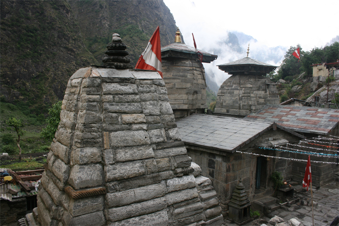
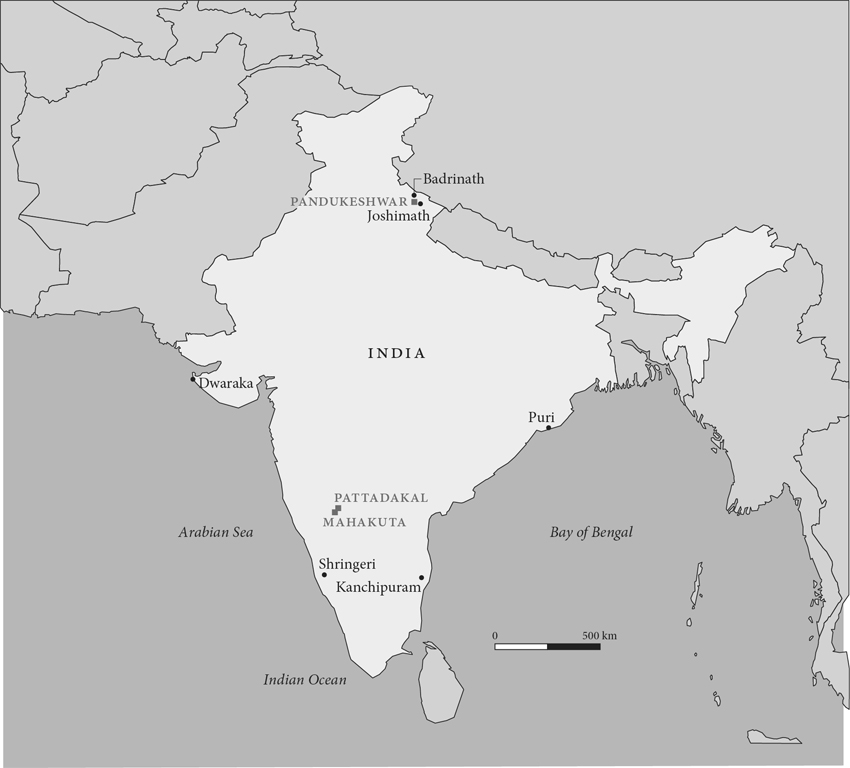
Pandukeshwar Village is an extraordinary place. It is situated in a Central Himalayan gorge near the glacial source of the mighty Alakananda-Ganga River (map 1).[1] It is also the last hamlet in Uttarakhand State in India to host a year-round population on a perilous ancient route that leads from the lush northern plains to Mana Pass, an entry into the frosty Tibetan plateau. Four early medieval lithic temples stand at Pandukeshwar (fig. 1). One temple, honoring Viṣṇu as Yogabadrī, is built in a typology of the Drāviḍa or southern Indian mode. The other three temples, honoring Gaṇeśa and Viṣṇu in his manifestations as Vāsudeva-Badrī and Lakṣmī-Nārāyaṇa, are built in architectural typologies that reference the Nāgara or northern Indian mode in dissimilar ways. Enshrined in these temples are gold and copper images of the Vaiṣṇava pantheon and four copperplate inscriptions. The later documents are written in Sanskrit and are datable to the ninth and tenth centuries.

To find such a variety of material remains at Pandukeshwar is astounding for at least three reasons. First, even today it is dangerous and difficult to reach this far-flung settlement.[2] Snowfall frequently obstructs access during winter months. Flashfloods and landslides triggered by cloudbursts periodically prevent visitors from reaching the village at other times of the year.[3] Second, despite the abundance of lithic monuments in India, very rarely does one find medieval temples built in the Drāviḍa and Nāgara modes standing side by side. In fact, Mahakuta and Pattadakal—the closest settlements where medieval temples in these modes can be seen next to one another—are located more than 2,800 kilometers away in Karnataka State in peninsular India (map 2). Third, despite the fact that the four temples at Pandukeshwar are visited by thousands of Hindu pilgrims annually and have been protected by the Archaeological Survey of India (ASI) since 1942, until now they have not been recognized as belonging to different modes of Hindu temple architecture. On the contrary, they have been regarded as specimens of Buddhist architecture and have been compared to edifices in such places as Nalanda in northeastern India.[4]

The quality and diversity of architectural modes and typologies at Pandukeshwar raise a series of questions. When and under what circumstances did the more broadly applicable knowledge of lithic temple construction and the more specialized knowledge of the Drāviḍa and Nāgara modes reach the Central Himalayas at large and this village in particular? How was this knowledge received and deployed? How did the accretion of monuments affect religious practices? Who were the original and subsequent patrons, builders, and users, and how were they connected to each other? How, if at all, was Pandukeshwar related to other fords (tīrthas) and sacred centers?[5] And finally, how do temple construction and the expansion of religious networks in the Central Himalayas intersect with social, political, and cultural changes elsewhere in South Asia?
I adopt an integrated method to investigate these questions. Given the extreme paucity of written records at Pandukeshwar and elsewhere in the Central Himalayas, it is the material record—built, landscaped, and sculpted—that constitutes the bulk of the historical evidence. Therefore, I carefully record and analyze this material evidence by (a) making maps that visualize spatial relationships among and between settlements; (b) drawing plans showing the orientation and arrangement of parts of individual temples; (c) using a Sanskritic terminology to understand temple forms; (d) employing precise language to record relationships between plans and elevations, external structures and internal systems, and original temple fabrics and later additions; and (e) forging a relative chronology. In addition, I look at epigraphs, oral narratives, toponyms, and contemporary practices. I use analytical tools devised by historians and anthropologists to decode the aforesaid items. I record geographical features that have had an impact on the locations of tīrthas and movements of people. I consider bridle paths that connect hill settlements to one another as well as cart roads that lead in and out of the mountain range. I also survey artistic accomplishments and political processes of earlier epochs and other parts of South Asia that influenced cultural production in the early medieval Central Himalayas.[6] Finally, I look briefly at the cultural expressions and political movements of subsequent centuries to understand how they may complicate my interpretations.
Using this methodology, I recover important moments in the history of Pandukeshwar and its region. I also cast new light on the transmission of architectural knowledge in early medieval India. This phenomenon, I posit, shaped Central Himalayan communities and reflected their variable aspirations. It also solidified a long-lived idea about India that continues to resonate with its residents today—that it is a cohesive geo-cultural entity that extends from the sandy shores of the Indian Ocean to the snow-clad Himalayas.
Ars Orientalis Volume 45
Permalink: https://doi.org/10.3998/ars.13441566.0045.002
For more information, read Michigan Publishing's access and usage policy.


